Boulder Cave closed for the season on Sept. 8, ahead of schedule. Thus, this cache has been disabled and is no longer in play for the GeoTour. It is now considered a Free Space on your Series 3 passport, meaning you don't have to find the cache to complete the passport. Instead, just write in the code word TOLMIE.
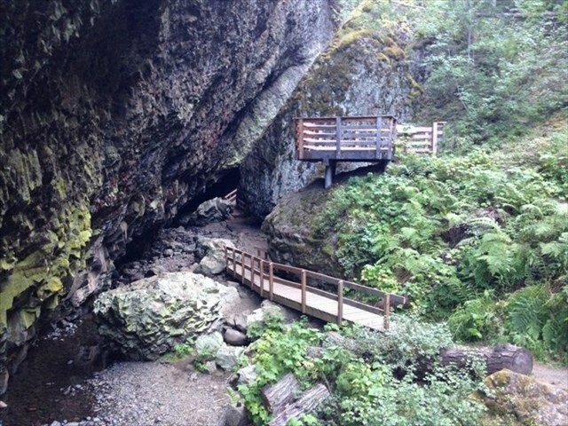
Welcome to the Boulder Cave National Recreational Trail. This trail leaves the Old Naches River Road near the Boulder Cave C.C.C trail shelter and climbs to the mouth of boulder cave. The cache is located just one step off the trail just prior to arriving at the cave.
Caves are unusual in the northwest, and Boulder Cave is the largest, most extensive cave of its kind. When most people think of caves, a limestone caverns or lava tubes come to mind. Boulder Cave is unlike any cave you have ever been in before. It took millions of years of volcanic action to create this landscape, and thousands of years for erosion and weathering to shape the features you’ll see on your visit.
Between 10 to 15 million years ago, lava flows occurred periodically in the Yakima basin and covered deposits of soft, loose rock and soil. The lava cooled, forming hard layers of basalt, and trapping the softer layers of loose sediment between.
Next, water went to work. Water is a patient sculptor, etching its signature into the basalt for thousands of years. The water is now carving though soft sedimentary layers of loose rock, soil, and ash deposited between lava flows. The stream is busy cutting out a new cave. This is how Boulder Cave may have looked if you visited Devil’s Creek thousands of years ago.
At Boulder Cave, the water flowing in Devil's Creek eroded a deep channel through the top layer of hard basalt and the softer layer of deposits beneath. When Devil’s Creek met the next layer of hard basalt, the creek stopped its downward action and instead continued to erode the softer deposits horizontally. In time, the horizontal erosion carved a hollow pocket underneath the top layer of basalt.
Approximately 25,000 years ago, the outer edge of this pocket weakened and collapsed into the hollow below, leaving an archway 350 feet long and 30 feet wide - Boulder Cave!! Today, Devil's Creek still flows through the cave that it created. The formation of Boulder Cave is unusual - most caves are old lava tubes or are formed from groundwater dissolving layers of limestone.
The trail to Boulder Cave was built by the Civilian Conservation Corps (CCC) in the 1930s and has been improved several times since then, most recently in 2014. The trail is signed as the Sun and Sage loop and it follows a small ravine. Make sure to keep an eye out for the lookout platform over the gorge just after the first hill. The path climbs gradually with a number of interpretive signs about the local ecology and history along the way.
Drinking water is supplied by a few healthy tugs on an old fashioned hand pump at the picnic area, but not along the Boulder Cave or River Trail. Picnic tables, fire rings, and a barrier free composting toilet are also on site.
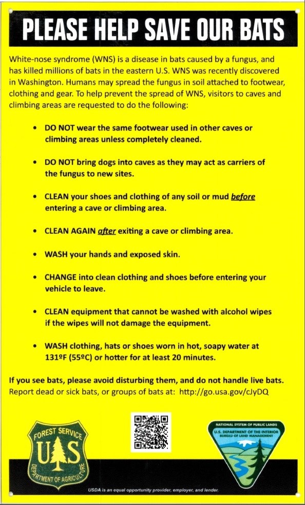
BOULDER CAVE CLOSED October 1st TO late May for protection of the Townsends Big Eared bats.
Boulder Cave is home to the only known population of Pacific Western Big-Eared Bats in this part of Washington State. The Pacific Western Big-Eared Bat is listed as a sensitive species in Washington and Oregon. A small population of 50 bats use Boulder Cave as a hibernaculum’s during the winter. In the 1920s and 1930s, the Boulder Cave bat population numbered in the thousands. These bats have historically used Boulder Cave during the summer, but presently do not. The big-eared bat is extremely intolerable to human disturbance. It appears the heavy human use during the summer has discouraged the big-eared bat's use.
By implementing the following guidelines, you could help encourage the bat to use Boulder Cave again.
- Please observe the following in the cave:
- Limit conversation and all noise.
- Whisper if you must talk.
- Stay on the trail and don't double back.
- Use dim flash lights.
- Keep the beam directed at the trail.
- Don't build campfires in the cave.
Thank you for your help!
2016 was the 100th anniversary of the National Park Service, and to celebrate, Visit Rainier and WSGA hosted the Visit Rainier Centennial GeoTour - 100 caches placed in and around Mount Rainier National Park. The geocaches highlighted the rich history, scenic wonders, quaint communities, and hidden gems of the Rainier region. Participants received geocoin and pathtag prizes for finding all the caches.

