Le pieghe delle (Die Falten der) Cinque Terre
Le pieghe delle Cinque Terre / Die Falten der Cinque Terre / The folds of the Cinque Terre
***Descrizione italiano***
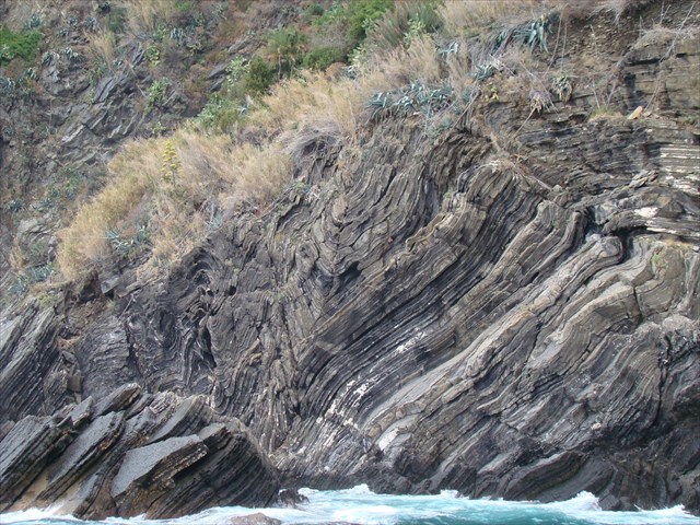
Le pieghe e le faglie che vorrei immaginare sono qui a Vernazza.
Vernazza è uno dei cinque famosi borghi che fanno parte delle "Cinque Terre".
Le "Cinque Terre" sono locate nella parte est della Liguria, la "Liguria di Levante".
Proprio qui gli Appennini incontrano le Alpi.
La "Liguria di Levante" è una striscia di terra completamente montuosa che si estende da Genova, nel nord ovest, fino a Luni nel sud est (Toscana).
Consiste primariamente di roccia sedimentaria di origine glaciale (arenaria) con ogni tipo di additivo quali Quarzo, ferro e manganese,
ma anche da Ardesia grigia-blu in forma pura fino alle piastre di Scisto lavorato dalle intemperie con contaminazioni di Marna.
La roccia ha pieghe verticali con formazioni che ricordano strati di pasta sfoglia.
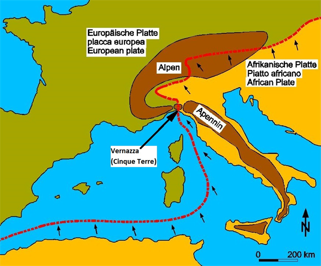
Geologicamente parlando, queste montagne che si affacciano sul mare nella loro intera lunghezza, sono nate nell'era Terziaria premendosi, piegandosi ed innalzandosi.
La placca Adriatica, che fa parte della più grande Placca Africana, durante l'Eocene (circa 53 milioni di anni fa), ha iniziato a muoversi verso nord.
(vedere l'immagine: Plattentektonik / placca tettonica / plate tectonics).
Si è conficcata come uno sperone nella placca Europea.
Così la roccia fu sollevata, premuta assieme e allo stesso tempo fu soggetta ad una forte pressione.
Quella montagnosa striscia di terra si è creata alla stessa maniera delle Alpi.
Questo movimento non è ancora arrivato ad una fine perché le placche tettoniche continuano a muoversi l'una verso l'altra ogni anno di circa 5 cm.
In nessun altro luogo potrai vedere queste bellissime pieghe negli strati della roccia come qui, nel sito della grande collisione.
Si può facilmente dividere ogni piega sulla base di 3 caratteristiche:
1. A seconda della relativa epoca dei materiali:
Anticlinale. Le pieghe hanno i materiali più antichi nel nucleo.
(vedere fig. 1)
Sinclinale. Le pieghe hanno i materiali più recenti nel nucleo.
(vedere fig. 2)
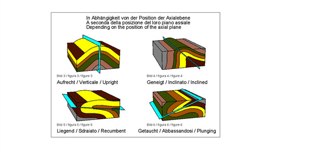
2. A seconda della posizione del loro piano assiale.
Verticale. Le pieghe quando il piano assiale è di circa 90°.
(vedere fig. 3)
Inclinato. Le pieghe quando il piano assiale è tra 85° e 10°.
(vedere fig. 4)
Orizzontale/sdraiato Le pieghe quando il piano assiale scende più basso di 10°.
(vedere fig. 5)
Cadendo/Abbassandosi. Le pieghe quando il piano assiale èruotando di 90° dalla posizione verticale.
(vedere fig. 6)
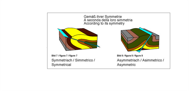
3. A seconda della loro simmetria.
Simmetrico. Le pieghe dividono il piano assiale in due metà approssimativamente simmetriche.
(vedere fig. 7)
Asimmetrico. Le pieghe dividono il piano assiale in due metà chiaramente non simmetriche.
(vedere fig. 8)
Ti invito ad inviare tutte le risposte via via EMAIL al mio profilo, e registrare la tua ricerca qui.
Ti informerò in caso ci fosse qualcosa di sbagliato.
Ora, le nostre domande:
- Puoi rilevare pieghe più simmetriche o asimmetriche?
Descrivere a parole proprie cosa si può osservare.
- Da quale era la placca Adriatica si sta spingendo nella placca Europea?
Una propria foto o quella del GPS di fronte alle pieghe è apprezzata, ma opzionale e ovviamente volontaria.
Fonti: Wikipedia, Internet

***Beschreibung deutsch***
Die Faltungen und Verwerfungen die ich euch vorstellen möchte, befinden sich hier, in Vernazza.
Vernazza ist einer der 5 berühmten Orte der "Cinque Terre".
Die "Cinque Terre" befindet sich in Ost-Ligurien, der "Liguria di Levante".
Genau hier stößt der Apennin auf die Alpen.
Dadurch ist "Liguria di Levante" ein durchweg gebirgiger Landstreifen, welcher sich von Genua, im Nordwesten bis nach Luni, im Südosten (Toskana) erstreckt.
Er besteht vorwiegend aus glazialen Sedimentgesteinen (Sandstein) mit allerhand Beimengungen, wie z.B. Quarz, Eisen und Mangan.
Aber auch aus graublauem Schiefer in Reinform bis zum verwitterten Plättchenschiefer mit mergeligen Verunreinigungen.
Der Fels weist senkrechte Faltungen mit Formationen auf, die an Schichten von Blätterteig erinnern.
Geologisch gesehen ist dieses, in seiner ganzen Länge ans Meer grenzende Küstengebirge, im Tertiär durch Pressung, Faltung und Hebung entstanden.
Ab dem Eozän, vor etwa 53 Millionen Jahren, führte die Adriatische Platte, welche ein Teil der größeren Afrikanischen Platte ist,eine direkt nach Norden gerichtete Bewegung aus.
(siehe Bild: Plattentektonik / placca tettonica / plate tectonics).
Plattentektonik / placca tettonica / plate tectonics
Sie drückte sich wie einen Sporn in die Europäische Platte hinein.
Dadurch wurde das Gestein angehoben, zusammengeschoben und zugleich hohem Druck ausgesetzt.
Dieses Küstengebirge ist also auf die gleiche Art und Weise entstanden wie die Alpen.
Diese Bewegung ist auch heute noch nicht zum Stillstand gekommen, da die Kontinentalplatten sich weiterhin mit etwa 5 cm pro Jahr aufeinander zu bewegen.
Nirgendwo sonst sieht man solch schöne Faltungen der Gesteinsschichten, wie hier am Ort des großen Aufpralls.
Man kann jede Faltung ganz einfach an Hand von 3 Merkmalen einteilen.
1. Entsprechend des relativen Alters der Materialien:
Antiklinale. Die Falten haben die ältesten Materialien im Kern.
(siehe Bild 1)
Syncline. Die Falten haben die jüngsten Materialien im Kern.
(siehe Bild 2)

2. In Abhängigkeit von der Position ihrer Axialebene:
Aufrecht. Falten, deren axiale Ebene bei etwa 90° liegt.
(siehe Bild 3)
Geneigt. Falten deren Axialebene zwischen 85° und 10° liegt.
(siehe Bild 4)
Liegend. Falten, deren axiale Ebene unter 10° eintaucht.
(siehe Bild 5)
Getaucht. Falten deren Axialebene über 90° von der vertikalen Position gedreht ist.
(siehe Bild 6)
3. Gemäß ihrer Symmetrie:
Symmetrisch. Die Falte unterteilt die Axialebene in zwei etwa symmetrische Hälften.
(siehe Bild 7)
Asymmetrisch. Die axiale Ebene teilt die Falte in zwei eindeutig nicht symmetrische Hälften.
(siehe Bild 8)
Du darfst diesen Earthcache sofort loggen, nachdem Du uns die Antworten auf folgende Fragen an unsere Profiladresse gesendet hast.
Falls etwas nicht stimmen sollte melden wir uns.
Nun zu unseren Fragen:
- Kannst Du mehr symmetrische oder asymmetrische Faltungen erkennen?
Beschreibe bitte mit Deinen eigenen Worten was Du beobachtet hast.
- Ab wann (Erdzeitalter) drückte sich die Adriatische Platte in die Europäische Platte hinein?
Ein Foto von Dir oder Deinem GPS vor den Falten würde mich freuen, ist aber nach den Guidelines optional und natürlich völlig freiwillig.
Quellen: Wikipedia, Internet

***Description english***
The folds and distortions which I would imagine are here in Vernazza.
Vernazza is one of five famous villages of the "Cinque Terre".
The "Cinque Terre" is located in eastern Liguria, the "Liguria di Levante".
Right here abuts the Apennines to the Alps.
This is "Liguria di Levante" a thoroughly mountainous strip of land that extends from Genoa, in the north-west to Luni, in the southeast (Tuscany).
It consists primarily of glacial sedimentary rocks (sandstone) with all kinds of admixtures, such as Quartz, iron and manganese.
But also from gray-blue slate in pure form to the weathered shale plate with Marly impurities.
The rock has vertical folds with formations reminiscent of layers of puff pastry.
Geologically, this, in its entire length to the sea bordering coastal mountains, originated in the Tertiary by pressing, folding and uplift.
From the Eocene, 53 million years ago, led the Adriatic plate, which is part of a larger African plate, from a directed directly northward movement.
(see image: Plattentektonik / placca tettonica / plate tectonics).
It squeezed like a spur into the European plate.
Thus, the rock was lifted, pushed together and at the same time subjected to high pressure.
That mountainous strip of land is also created in the same manner as the Alps.
This movement is also still not come to a halt because the tectonic plates continue with about 5 cm per year to move toward each other.
Nowhere else will you see such beautiful folds of the rock layers, as here at the site of the great collision.
One can easily be divided on the basis of 3 features every wrinkle.
1. According to the relative age of the materials:
Anticline. The folds have the oldest materials in the core.
(see figure 1)
Syncline. The folds have the latest materials in the core.
(see figure 2)
2. Depending on the position of its axial plane:
Upright. Folds, the axial plane is about 90 °.
(see figure 3)
Inclined. Folds, the axial plane is between 85 ° and 10 °.
(see figure 4)
Lying/Recumbent. Folds whose axial plane dips lower than 10 °.
(see figure 5)
Dipped/Plunging. Folds whose axial plane is rotated through 90 ° from the verticalposition.
(see figure 6)
3. According to their symmetry:
Symmetrical. The fold divides the axial plane into two approximately symmetrical halves.
(see figure 7)
Asymmetrical. The axial plane divides the fold into two clearly not symmetrical halves.
(see figure 8)
Please EMAIL all answers via my profile and log your find here.
I will inform you in case there is something wrong.
Now to our questions:
- Can you detect more symmetrical or asymmetrical folds?
Please describe in your own words what you have observed.
- From when (era), the Adriatic plate is pressed into the European plate?
A photo of yourself or your GPS in front of the folds would be happy, but is in accordance with guidelines only optional and of course completely voluntary.
sources: Wikipedia, Internet