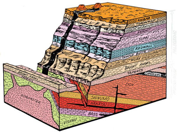
The Grand Canyon of the Colorado River is a world-renowned showplace of geology. Geologic studies in the park began with the work of John Strong Newberry in 1858 and continue today. The Grand Canyon’s magnificent display of layered rock reveals the region’s geologic history like no other place. Other geologic forces you can see and study at Grand Canyon include movement of the Earth’s tectonic plates, erosion by wind and water, and volcanic activity. Grand Canyon is located on the Colorado Plateau. This geologic province is a large area in the Southwest characterized by nearly horizontal sedimentary rocks lifted 5,000 to 13,000 feet above sea level. The plateau’s arid climate and the carving power of wind and water have produced many striking erosional forms, culminating in the Grand Canyon. The canyon’s mile-high walls display a largely undisturbed cross section of the earth’s crust extending back some 2 billion years. Three granite gorges expose crystalline rocks formed during the early to middle Proterozoic eon (late Precambrian era). Originally deposited as sediments and lava flows, these rocks were intensely metamorphosed about 1,750 million years ago. Magma rose into the rocks, cooling and crystallizing into granite, and welding the region to the North American continent. Beginning about 1,200 million years ago (in the late Proterozoic eon), 13,000 feet of sediment and lava were deposited in coastal and shallow marine environments. Mountain building about 725 million years ago lifted and tilted these rocks. Subsequent erosion removed these tilted layers from most areas, leaving only the wedge-shaped remnants you can see in eastern Grand Canyon. Rock layers formed during the Paleozoic era are the most conspicuous layers you will find in Grand Canyon’s walls. Coastal environments and several marine incursions from the west between 550 and 250 million years ago deposited sandstone, shale and limestone layers that are a combined 2,400 to 5,000 feet thick. These include layers from the Cambrian, Devonian, Mississippian, Pennsylvanian and Permian periods. Erosion has removed most Mesozoic era evidence from the park (the Mesozoic lasted from 253 to 66 million years ago), although you can still find small remnants of Mesozoic rock, particularly in western Grand Canyon. Those rock outcrops suggest that 4,000 to 8,000 feet of sedimentary layers from the Mesozoic, also known as the age of dinosaurs, once covered the Grand Canyon area. Layers from the Cenozoic era (the age of mammals) are limited to western Grand Canyon and terraces near the river. A few sedimentary deposits formed in lake beds, but the most spectacular recent deposits are the lava flows and cinder cones on the Shivwits and Uinkaret Plateaus. Volcanic activity began about 6 million years ago and has continued to within the last several thousand years. Spectacular lava cascades frozen in time on canyon walls have helped us date when the Grand Canyon was carved. The Grand Canyon itself is a late Cenozoic feature, characteristic of renewed erosion during this time. Vigorous cutting by the snow-fed Colorado River carved the canyon’s depth. Canyon widening has been held in check by the region’s dry climate. The asymmetry between rapid downcutting and slow widening created the Grand Canyon rather than a more typical broad (and nondescript) river valley. Although violent storms may send flash floods rushing down narrow side canyons, the lack of steady moisture has created a stark landscape of mostly naked rock. Harder, erosion-resistant rocks such as Coconino Sandstone and Redwall Limestone have eroded into bold cliffs. Softer layers melt into slopes like the Tonto Platform (made up of Bright Angel Shale) and the Esplanade (composed of Hermit Shale). The oldest, crystalline rocks are chiseled into the craggy cliffs of the granite gorges. Nearly 40 identified rock layers form the Grand Canyon’s walls. They have attracted students of earth history since 1858. Because most layers are exposed all along the canyon’s 277-mile length, they afford scientists the opportunity for detailed study of environmental changes from place to place (within a layer) in the geologic past. Geologic evolution through time can be studied through the changes between different layers.< It was the work of geologists that began changing the public’s opinion of the Grand Canyon region from “a worthless locale” to “the most sublime of earthly spectacles.” After nearly 150 years, geologists are still not finished studying the Grand Canyon. In the mid-1970s, a new rock layer was identified in the canyon walls. Scientists continue investigating how the environment affects rock formation. Perhaps the biggest question of all—how the Colorado River chose this course and began carving the canyon—still awaits a clear answer. Walk a million times on this timeline trail To humans a million years seems unimaginably long, more than 10.000 lifetimes.
This trail helps you shift from human time to geologic time. about time as you walk the trail.
Go to this Earthcache and walk two billion Years of Grand Canyon history! The Earthcache For this Earthcache, you first have to park your car at N 36° 03.907 W 112° 07.121. Then walk to Waypoint 1 at N 36° 03.914 W 112° 07.173. Answer the following question:
Question 1: Here you see 17 sorts of stonesfrom the Grand Canyon. Describe me five of these. (Think about the color, stripes etc.)
Go further to Waypoint 2 at N 36° 03.917 W 112° 07.243. “Climate change affect ecology, geology, and you. 20.000 years ago, Grand Canyon’s in a much cooler and wetter climate cycle.”
Question 2: What’s the name of the Stone you’ll find here? Looking to the First word of the name, what’s the agreement with trees?
Then we’re going to Waypoint 3 at N 36° 03.917 W 112° 07.249.
Question 3: Say the name of the Stone you find at Waypoint 3. Say me also the relationship between (the origin of) this Stone with the Grand Canyon.
Go to Waypoint 4 at N 36° 03.909 W 112° 07.263. Question 4: How is this stone created? If you can, give me a geologic notion for this trial. I like it if you make a Photo from yourself or your GPS at N 36° 03.888 W 112° 07.338. (This is optional)
Go further to Waypoint 5, N 36° 03.828 W 112° 07.377. Here you find some information about the layers of the Grand Canyon.
Question 5: Very near this information sign, you find the Kaibab Limestone. Could you find fossils in this Stone? Here ends this Earthcache, but the trail not! If you want, you can walk much more on this trail! E-Mail your answers to Hesiodus. Logs without answers, or with many mistakes, will be deleted!