제주 중문대포해안 주상절리대
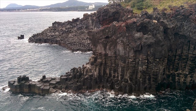
이곳의 주상절리대는 서귀포시 중문동과 대포동의 해안선을 따라 약 2km에 걸쳐 해안절벽에 수려하게 발달되어 있다. 제주도는 신생대 제4기에 형성된 화산섬으로서 주로 현무암질 요암으로 구성되어 있다. 절리는 암석에 발달된 갈라진 면으로 화산암에는 주상절리와 판상절리가 발달된다.
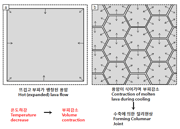
주상절리는 주로 현무암질 용암류에 형성되는 기둥 모양의 평행한 절리로서 고온(약 900˚C)의 용암이 차가운 바다물에 의해 급격히 냉각되는 과정에서 수축작용에 의해 생겨난 '틈'이다. 위에서 보면 일정한 다각형(4~7)의 형태를 보이고 있다. 이곳의 주상절리는 최대 높이 25m에 달하는 수많은 기둥모양의 암석이 해안선을 따라 규칙적으로 형성되어 있어 마치 신이 빚어 놓은 듯한 느낌을 자아내게 하고 있다. 약 25만년~14만년 전에 '녹하지악' 분화구에서 용암이 분출되면서 형성된 조면현무암으로 이루어진 이곳의 주상절리대는 학술적, 경관적 가치가 인정되어 문화재로 지정 보존되고 있다.
[로그하는 방법]
1) 바다물과 만나는 부분은 절리가 뚜렷하지만 클링커층으로 덮여있는 윗부분에는 절리가 희미하게 없어진다. 그 이유는 클링커층에 덮인 용암이 공기와의 접촉이 차단되어 천천히 식기 때문이다. (진실/거짓)
2) 용암이 빨리 식을수록 주상절리 기둥의 굵기는 가늘어지고, 주상절리 표면에 발달한 띠구조의 간격은 좁아진다. (진실/거짓)
3) 주상절리대 위를 덮고 있는 클링커층의 색상은 무엇입니까?
4) 주상절리대를 배경으로 당신의 GPS(또는 지오캐싱 아이템)를 찍은 사진을 올려주세요.
5) 위 1~4의 답을 제 Profile에 있는 메시지창을 이용해 제게 보내주세요. 이제 로그하셔도 됩니다. 답에 이상이 있으면 제가 연락드립니다.
<관람가능시간 : 08:00~18:00, 연중무휴>
(Picture source: http://www.csgeop.kr)
Columnar Joint at Jeju Jungmun Daepo Coast
Jusangjeollidae(Colimnar Joint) is rocky cliffs with joints of avout 2km in length along the coastal line from Jungmun-dong to Daepo-dong of Seogwipo-si. Jeju island is a volcanic island formed mostly of basaltic lava in the Pleistocene Period of Cenozoic Era. The joint is a pattern of cracks in rocks. There are two types of joints; columnar joint and platy joint.
Jusangjeollidae is a pillar-shaped joint formed by basaltic lava. As high-temperature(about 900˚C ) basaltic lava is cooled down rapidly with cold sea water, it shrinks in volume, often producing a columnar joint. When viewed from the top, four to seven-sided polygonal colums of basaltic rocks can be oberserved. Basaltic columns of 25m in height look like a regular stack of pillars, which can be called the nature's masterpieces. They are presumed to be formed of trachybasaltic rock about 250,000~140,000 years ago. This columnar joint, including its vicinity, is designated as Natural Monument No. 443 for its scenic value and academic purposes.
[To claim this Earth Cache, please answer the following questions!]
1) You can see joint shapes are more clear in the lower part which are near from the water. But the shapes are not clear in the upper part of the joints which are covered by clinker because the lava covered with clinker is blocked out from the air and is being cooled down slowly. (True or False)
2) Fast cooling lead to narrower columns and narrower striae? (True or False)
3) What is the color of clinker covering the upper part of Columnar Joint?
4) Please upload the photo of your GPS(or any Geocaching item) with Columnar Joint in the background!
5) Please send the answers to me by message on my profile! You may log now. If the answer is not correct, I will contact you.
<Opening Hour : 08:00~18:00, From Sunday to Saturday>
Congrats to Kulturmensch on FTF!
| I have earned GSA's highest level: |
 |