Português
(Obrigado Luis Serpa pela tradução)
A ilha do Faial, estando muito perto do rifte médio-Atlântico, onde 3 grandes placas tectónicas se juntam, tem uma história violenta de erupções vulcânicas e actividade tectónica.
O colapso do cone da Caldeira a apenas 1000 anos (antes disso, estima-se que o ponto mais alto do Faial fosse aproximadamente de 1500m, agora é de 1043m), a erupção do Cabeço do Fogo em 1672/1673, a erupção do Vulcão dos Capelinhos em 1957/1958, um grande sismo (5,8 na escala de Richter) em 1998. Muitos dos vulcões ainda são considerados activos, especialmente na zona entre a Caldeira e o Vulcão dos Capelinhos. Depois da erupção do Vulcão dos Capelinhos, foram adicionados 2,4km2 ao Faial. De momento, restam apenas 0,56km2.
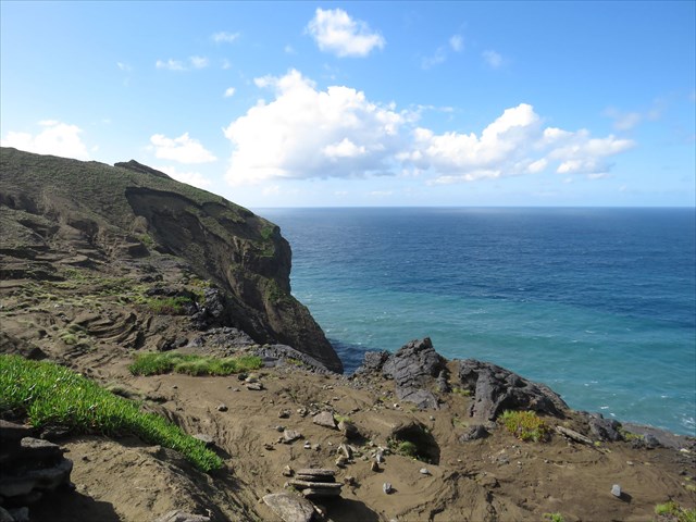
Esta área é destruída pela erosão do mar, vento, chuvas torrenciais e interferência humana.
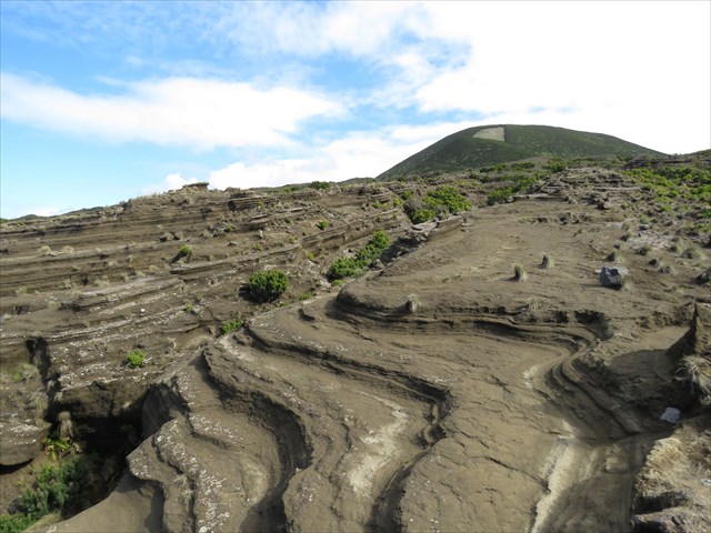
Durante a erupção do Vulcão dos Capelinhos, uma grande quantidade de cinzas e bombas vulcânicas foram espalhadas sobre uma vasta área do Faial. Em certas condições, estas cinzas podem-se converter em tufos, mas estes permanecem relativamente moles e assim, sujeitos à erosão. Para além do próprio vulcão, esta erosão pode também ser claramente vista numa parte da antiga costa do Faial, ao lado do antigo vulcão do Costado da Nau.
Nesta área encontra-se a cache.
Ao caminhar ao encontro da cache, e estando no GZ, pode-se ver claramente sinais da erosão na camada das cinzas e do tufo, que cobre a terra e o escorregamento na encosta do vulcão do Costado da Nau na parte Oeste.
English:
The island of Faial, laying very close to the mid-atlantic ridge where 3 major tectonic plates come together, has a violent history of volcanic and tectonic activity.
The cone of the Caldeira collapsing only 1000 years ago (before that time Faial’s highest point was an estimated 1500 meters (now 1043 m), the eruption of Cabeço do Fogo in 1672/73, the eruption of Vulcão dos Capelinhos in 1957/58, a major earthquake (5,8 at the Richter scale) in 1998. Most of the volcanoes are still considered active and especially in the area between the Caldeira and the Capelinhos volcano . After the eruption of Vulcão dos Capelinhos, 2,4 km2 was added to Faial. At the moment only 0,56 km2 is left.
The area is destroyed by erosion by sea, wind and torrential rains and human interference.
During the eruption of the Vulcão dos Capelinhos huge amounts of volcanic ashes and lava bombs were spread over a large area of western Faial. Under some conditions these ashes are converted to tuff but they will always stay relatively soft and thus subject to erosion. Besides on the volcano itself this erosion can be seen clearly on a part of the old coastline of Faial, next to the ancient volcano of Costado da Nau.
In this area we find the cache.
Walking towards the cache and standing at GZ you can clearly see the signs of erosion in the layer of ashes and tuff that cover the land and in the landslide on the old volcano of Costado da Nau in the west.