Skip to content

Os Molhes do Arade EarthCache

Hidden : 4/2/2016
Difficulty:
1.5 out of 5
Terrain:
2.5 out of 5

Size: Size:   other (other)

Join now to view geocache location details. It's free!

Watch

How Geocaching Works

Please note Use of geocaching.com services is subject to the terms and conditions in our disclaimer.

Geocache Description:


Os Molhes do Arade / The Arade Jetties

O Rio Arade

O rio Arade é um rio de Portugal localizado na região de Algarve, que nasce na serra do Caldeirão e passa por Silves (Portugal), Portimão e Lagoa indo desaguar no oceano Atlântico, em Portimão, imediatamente a leste da praia da Rocha.

No tempo dos descobrimentos portugueses era navegável até Silves (Portugal), onde existia um importante porto. Hoje, devido ao enorme assoreamento, apenas pequenos barcos aí podem chegar.

The Arade River

The Arade River is located in the region of Algarve. It has is source in Serra do Caldeirão and passes through Silves, Lagoa and Portimão going flow into the Atlantic Ocean, in Portimão, immediately east of Praia da Rocha.

At the time of the Portuguese discoveries it was navigable to Silves, where there was an important port. Today, due to massive siltation, only small boats can get there.

A morfodinâmica da foz do rio Arade / The morphodynamics of the mouth of Arade River

Antes da Praia da Rocha se tornar uma estância balnear conhecida internacionalmente, a vila de Portimão estava ligada ao país e ao mundo através do seu porto marítimo. A vida económica desta cidade dependia, desde tempos remotos, do comércio que se fazia através do rio, por onde se escoava a produção agrícola do interior serrano e as conservas de peixe fabricadas nas unidades industriais instaladas na frente ribeirinha desde meados do século XIX. Dada a importância deste tráfego marítimo e do perigo a que estavam sujeitos todos aqueles que dirigiam-se a barra por causa do assoreamento, a melhoria das condições de entrada e de navegação no rio foi uma preocupação constante das autoridades, dando origem a vários estudos e intervenções.

Cedo se verificou que o rio era sinuoso e variável, apresentando diversos baixios. Para isto concorriam causas naturais - os sedimentos trazidos pelas cheias - e artificiais, como as alterações às margens para aumento de campos agrícolas e construção de moinhos, a instalação de represas no leito para irrigações, o deslastre dos navios que frequentavam o porto, a falta de fiscalização das práticas dos proprietários ribeirinhos e a ausência de obras de conservação das margens e leito.

Em 1926 e 1927, o mau estado da barra e os prejuízos causados à pesca e à indústria conserveira da sardinha levaram à realização de dragagens no canal de acesso e no estuário do rio, sendo retirados cerca de 360 000m3 de sedimentos. Contudo, os bancos de areia rapidamente se restabeleceram e a situação manteve-se idêntica.

Perante isto, chegou-se à conclusão que o problema do assoreamento e a dificuldade de acesso – impedindo a entrada de barcos de maior porte e obrigando ao transbordo das mercadorias para embarcações menores -, só poderiam ser resolvidos com a construção de dois molhes que fixassem a embocadura, direccionando as águas do rio e impedindo a entrada das cheias marítimas empurradas para dentro do estuário. Assim, em 1946 teve início a construção dos molhes – um enraizado na Ponta de St.ª Catarina e outro na Ponta do Altar. Os trabalhos ficaram terminados em 1959.

(Texto retirado de Praia da Rocha: um paradigma da antropização do litoral)

Given the importance of maritime traffic for the city of portimão, it was very important secure the conditions of entry and navigation on the river. So the mouth of the river Arade was a constant concern of the authorities, leading to a number of studies and interventions on preventing the silting of the river.

It was soon found that the river was tortuous and variable, with many shoals. For this competing natural causes, like the sediments brought by floods and artificial causes such as changes to the margins to increase agricultural fields and construction of mills, installation of dams in the bed for irrigation, the shedding of ships that frequented the port, the lack of monitoring practices of riparian owners and the lack of conservation works on the banks and bed.

In 1926 and 1927, the poor condition of the navigability of the river and the damage to fishing and canning sardines industry, led to the realization of a dredging at the access channel and in the river estuary. However, the sandbars were quickly restored and the situation remained the same.

It was concluded that the silting problem and the difficulty of access - preventing the entry of larger ships and forcing the transhipment of goods to smaller vessels - could only be solved with the construction of two jetties on the mouth of the river, directing the river waters and preventing the entry of sea floods into the estuary. Thus in 1946 began the construction of the jetties - one rooted in Ponta St.ª Catarina and one in Ponta do Altar. The works were completed in 1959.

(Text form Praia da Rocha: um paradigma da antropização do litoral)

O que é o Assoreamento? / What is the Siltation?

O Assoreamento é o processo em que cursos de água são afetados pelo acúmulo de sedimentos, o que resulta no excesso de material sobre o seu leito e dificulta a navegabilidade e o seu aproveitamento. Originalmente, esse é um processo natural, mas que é intensificado pelas ações humanas, sobretudo a partir da remoção da vegetação das margens dos rios.

O processo de assoreamento costuma ocorrer da seguinte forma: com as chuvas, o solo é lavado, ou seja, a sua camada superficial é removida, e os sedimentos (partículas de solo e rochas) são transportados por escoamento em direção aos rios, onde são depositados. Quando não há obstáculos para esses sedimentos, função geralmente exercida pela vegetação, uma grande quantidade é depositada no fundo das redes de drenagem.

Esse material depositado é levado pelo próprio rio e, quando encontra locais mais planos, onde a velocidade do curso de água não é muito acelerada, deposita-se no fundo, acumulando e, eventualmente, formando bancos de areia ao longo do curso de água. Quando a quantidade de sedimentos é muito grande e pesada, eles transportam-se por rolamento (no fundo dos rios) ou se acumulam no leito normal, trazendo prejuízos ao escoamento fluvial.

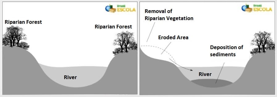
Quando o ser humano remove a vegetação, principalmente a mata ciliar (a vegetação que se encontra nas margens dos cursos de água), o processo acima citado intensifica-se, além de gerar o surgimento de erosões nas proximidades do próprio rio, conforme ilustram as imagens a seguir:

Imagem 1

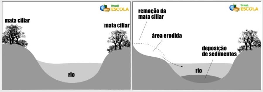
(retirado de Brasil Escola)

Siltation is the process where water bodies are affected by the accumulation of sediments, resulting in excess material on his bed and hinders navigation and its use. Originally, this is a natural process, but that is intensified by human actions, especially since the removal of the riverbanks vegetation.

The process of sedimentation usually occurs as follows: with the rain, the soil is washed, or its surface layer is removed, and sediments (particles of soil and rock) are transported by flowing into the rivers, where they are deposited. When there are no obstacles to these sediments, function usually exercised by vegetation, a large amount is deposited at the bottom of the drainage networks.

This deposited material is carried by the river itself, and when it finds more local plans, where the velocity of the stream is not very accelerated, deposits in the background, accumulating and eventually forming sandbanks along the course d ' water. When the amount of sediment is very large and heavy, they carry up by rolling (at the bottom of rivers) or accumulate in normal bed, bringing damages to the river flow.

When man removes vegetation, mainly riparian vegetation (vegetation that lies on the banks of watercourses), the above process is intensified, and generate the emergence of erosion near the river itself, as illustrated the following images:

Imagem 1

(From Brasil Escola)

Para "Logar" esta EarthCache / To Log this EarthCache

Para “logar” esta cache deve visitar o local, nas coordenadas indicadas.

Depois deve responder às seguintes questões e enviar as respostas para o seguinte endereço jpp.geocaching@gmail.com

1. Explique o que se entende por assoreamento.

2. Qual a função principal para a construção dos molhos na foz do rio?

3. Considera que os molhes estão a cumprir a sua função? Para isso observe a foz do rio, consegue observar bancos de areia? A foz parece-lhe navegável até à zona de marina de Portimão a Noroeste da sua localização?

4. Com a construção dos molhos a linha de foz entre o rio e o oceano, aumentou, diminuiu ou manteve-se igual?

5. Alem de todas as pedras à volta, o molho onde se encontra é constituído por grandes blocos de cimento. Quantos blocos de cimento pisou desde a praia até ao farol? (ver imagem a baixo em caso de dúvida)

a. 76 blocos

b. 84 blocos

c. 95 blocos

d. 109 blocos

e. 125 blocos

6. (Opcional) Tire uma foto de com algo que o identifique como geocacher no local!

Em seguida poderá fazer o seu “found it” on-line!

To log this cache you must visit the coordinates above.

Then you must answer the following questions and send the answers to the following address jpp.geocaching@gmail.com

1. Explain what is a silting.

2. What is the main function of jetties at the river mouth?

3. Do you think that the jetties are fulfilling their function? For this observe the mouth of the river, can you observe sand banks? The mouth seem to you waterway to the marina area of Portimão, northwest of your location?

4. With the construction of jetties, the mouth line between the river and the ocean (the gateway into the river), increased, decreased or remained the same?

5. Besides all the rocks around, the jetty consists of large concrete blocks. How many of them did you stepped, from the beach to the lighthouse? (See image below if in doubt)

a. 76 blocos

b. 84 blocks

c. 95 blocks

d. 109 blocks

e. 125 blocks

6. (Optional) Take a picture with something geocache related in the coordinates!

Then you can claim your "found it" online!

This page was generated by Geocaching Portugal Listing Generator

Additional Hints (No hints available.)