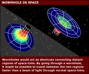
A wormhole is a theoretical passage through space-time that could create shortcuts for long journeys across the universe. Wormholes are predicted by the theory of general relativity. But be wary: wormholes bring with them the dangers of sudden collapse, high radiation and dangerous contact with exotic matter.
In this case, clicking the picture above will take
you to another Geocaching Wormhole. It should be
noted that most-likely the trip will not collapse
the wormhole between here and there, but will give
you more fun playing with Geocaching Puzzles. :)

Redford Township is a charter township in Wayne County in the U.S. state of Michigan and a suburb of Detroit. The population was 48,362 at the 2010 census.
Redford Township is a dynamic community of nearly 52,000 people located in about 11.25 square miles on the western border of Michigan’s largest city, Detroit. Many Redford citizens are second- or third-generation residents. The Township is a short drive from anywhere in the region and has a wide mix of people of all ages, races, ethnic and religious backgrounds and for the most part, reflects the many cultural faces of America.
Redford is home to 15 different parks. These areas can easily be considered one of Redford’s most valuable resources. Our residents enjoy a brand new splash park, outdoor ice rink, skate park, ball diamonds, tot lots, walking paths and more. Redford parks have something for everyone.
Residents come together throughout the year to enjoy such events as Bunny Brunch, Cinco de Mayo Celebration, Document Destruction Day, Perennial Exchange, Memorial Day Parade, Fireworks at Glenhurst, Oktoberfest, Olde Fashioned Holidays and Parade, just to name a few.
1883 Wayne County Map of Redford
The name Redford was chosen because Indians and pioneers forded the River Rouge where the river runs through Redford. The word 'rouge' is French for the color red and it was given this name after several larger townships in the county were split in the mid-1800's.
Redford Township used to be much larger than it is today. In 1883, the map above shows the size of Redford. The borders of Redford Township ran from Inkster Road to the West, along 8 mile Road to the North, along Joy to the south, and Greenfield to the East. At that time, it was 36 Square miles with much of the area being farmland.

1936 map of Redford and part of Detroit
In the 1920's, the eastern portions of the Township were Annexed by the City of Detroit. This annexation ceased in 1926 when the township was given "charter" status by the Michigan legislature. This is why many items in Western Detroit around the Lahser Road corridor have the name "Redford" in them, such as the Redford Theatre, which is just north of Grand River Ave. on Lahser Road.

Redford, Today (2016)
It currently has north-to-south running borders with Detroit along Five Points at 8 Mile Road to Telegraph Road between 6 and 7 Mile Roads, and even a bit further East south of I-96 along Joy Road. Because of the State stopping the Annexation by Detroit, it's expected that Redford will remain the geographic size that it is currently for the forseeable future with no gain or loss of territory.
Redford has various interesting things that have been part of it since it's inception. Churches, attractions, neighborhoods, schools, cemeteries, theatres, and most of all, friendly residents.
Not everything that is within the animated picture below is currently within the borders of Redford Township as it is today, but some of it may be from what once was part of Redford in the past or within what was the borders of Redford and annexed by the City of Detroit.
**PUZZLE is BELOW**

There are ten single digits that you will need to locate within the animation,
N42 ##.### -- W083 ##.###
in order to solve the puzzle.
You will NOT have to do any calculations to solve this puzzle.
NORTH coordinates are in their proper order
-AND-
WEST coordinates are in their proper order
GeoChecker to check your work, per request.

Good Luck and Thanks for Visiting Redford!