
The highest point on the Brandy Pad walk
Looking west towards Slieve Bernagh with the Hare's Gap to the right
THE EVENT & WALK
We invite participants to join us at Meelmore Lodge car park (see Waypoint 01 below) by no later than 09.45 on Saturday, 30th April. The walk will start here at 10.00 sharp.
The walk will be in mountainous terrain with the highest point at 1650 feet (500 m) above sea level, so it is strongly recommended that participants come properly equipped, given that the weather can change very quickly. Your equipment 'check list' for the day should include: good walking boots; warm clothes; a woollen hat and gloves; a waterproof coat and trousers; food and water.
The EVENT itself will held at the published coordinates at the Hare’s Gap, starting at 11.30 and lasting half an hour.
To log ‘ATTENDED’ for this event, it will be necessary to be present at the event meeting point at the Hare’s Gap for at least some of the 30 minutes between 11.30 and 12.00. Whilst we hope everyone will want to start the walk together, it is ok to walk independently to where the event is being held.
Once the event is over, those who want to can continue the walk along the Brandy Pad, ending at the Bloody Bridge car park next the coast.
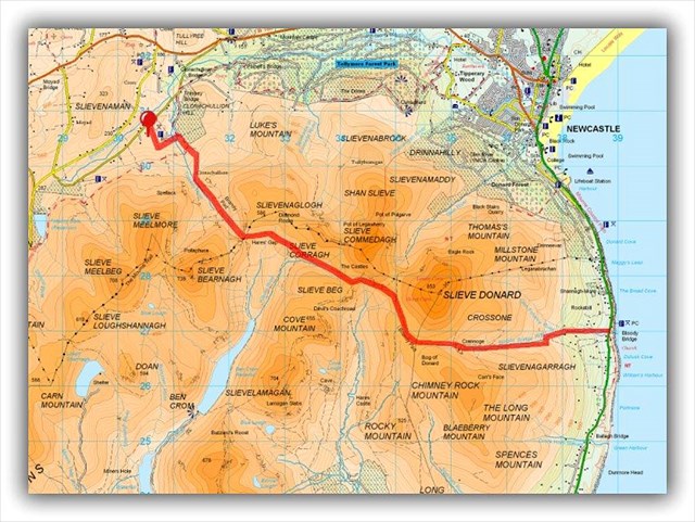
The Brandy Pad ‘Walk Route’
(Thanks to killyman1 for this image)
The walk planned for the day along the Brandy Pad will enable participants to find up to 20 caches or more (including an earthcache), all of which are on, or very close to, the Brandy Pad. For the more adventurous geocachers, there are other caches in the area at higher levels that could possibly be found also.
In addition, there will be the opportunity to claim Joint-FTF on a number of new caches that will be published on the day, to coincide with this event and the group walk along the Brandy Pad afterwards.
Unfortunately, DOGS are NOT ALLOWED along this route.
For more about the Brandy Pad Walk, see: ‘Trassey to Bloody Bridge’ by WalkNI.com, which includes some stunning photos of the route and the surrounding mountains, taken in great weather!
PARKING
It is suggested that participants leave their cars at ‘The Start’ at Meelmore Lodge (see Waypoint #01 below), where there's plenty of room, parking is FREE and, for 'added security', there is CCTV coverage. The ‘Mournes Rambler Bus’ runs regularly around the foot of the mountains and can be used at the end of the walk to get from the Bloody Bridge car park back to Meelmore Lodge.
Alternatively, some may wish to leave their cars at The Bloody Bridge Car Park (see Waypoint #02 below) BEFORE the walk and share transport 'with others' around the mountains to the starting point, on the west side, at Meelmore Lodge. Taking up this suggestion will mean cars will be ‘ready and waiting to get into’ at the end of the day’s walk, facilitating a fast 'get away'!.
Details of suggested parking places are shown below.
PLANNING TO ATTEND?
If you are planning to attend THIS EVENT, please ADD a ‘Will Attend’ log to the cache page. Thank you.
You might also like to add the event to your Watch List, so you can 'pick up' any updated information posted by the organisers.
Keep an eye out too for any relevant postings about THIS EVENT on the ‘Geocaching Ireland’ and ‘The Emerald Isle Cachers’ pages on Facebook.
We hope to see a good crowd on the day!
DISCLAIMER
By participating in this walking event, YOU agree de facto that your participation is at YOUR OWN RISK and that the event organisers CANNOT be held responsible
for any accident, injury or loss to you or your belongings
while participating in this event.
You are urged to exercise due caution at all times.
POSTSCRIPT
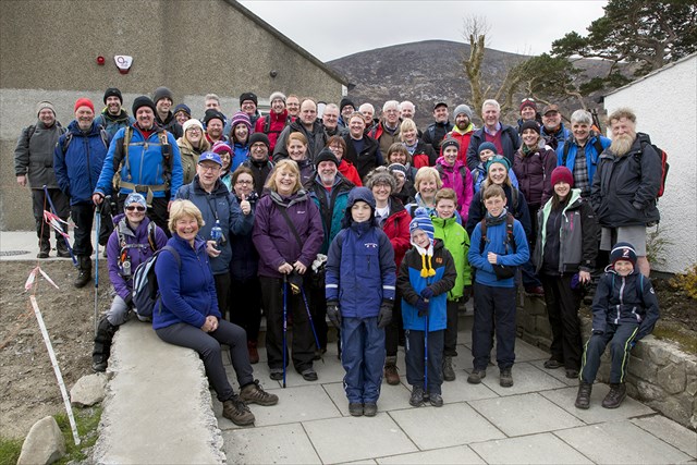
Majority of EVENT 'Attendees' at Meelmore Lodge just before the start of the walk!
It was such an amazing turnout! Thanks to everyone who made the effort to join us.