Butser Hill dominates the skyline for many miles around, its loftiness accentuated by the tall telecommunications tower that sits near its summit, enabling the cacher to spot it from quite a distance. A favourite place all year round, Butser Hill is part of Queen Elizabeth Country Park, of whom I am grateful for their kind permission to site this EarthCache.
The summit has a nearby car park. A tarmac road leads to the buildings at the base of the tower, and grassy footpaths criss-cross the hill, making it easier for strollers and wheelchairs to traverse the hill, although wheelchairs may need help during 'non-dry weather', etc. Wet weather combined with wind can make conditions on the summit area rather taxing, so please bear this in mind with younger children, etc. Similarly, despite being in southern England, snow (albeit rare) and ice can make the summit area quite dangerous, so adequate clothing and precautions should be taken if venturing out in such weather.
As usual with EarthCaches there is no physical cache. To log this EarthCache, the cacher is required to study the view and the landscape that one can see from the summit of Butser Hill, then email me the answer to the questions below.
The name ‘Butser’ comes from the Old English 'Bryttes Oran', meaning 'Briht's slope'. 'Oran' is Old English for flat topped hill and/or steep slope', and perfectly describes the outline of the hill. Butser, as part of QECP, is designated a Site of Special Scientific Interest and since 1998 has been a National Nature Reserve. The underlying geology in combination with these slopes has enabled Butser and its surrounding slopes to be the second largest area of calcareous grassland in Hampshire.
At the coordinates one will find yourself at the Trig Point, on the summit of Butser Hill. Take a moment or two to take in the views - look north-westwards over the town of Petersfield and beyond, or take in the view southwards, looking out over the large natural harbours between Chichester and Fareham, out across the Solent and on towards the Isle of Wight.
On the Trig Point is a small silver-coloured plaque.
QUESTION 1 - What month and year is inscribed on the plaque?
At the Trig Point you will be 271m above sea level. Pilot Hill, towards Winchester, is the only other hill in Hampshire that is higher than Butser Hill. Both qualify to be 'Marilyns'.
QUESTION 2 - Why do these hills qualify as such?
As you stand on the summit, you are standing on the ‘Chalk’, a unique white-coloured limestone, formed in warm shallow seas during the Cretaceous Period. Although not well exposed at this summit area, if one looks down to the A3 Dual Carriageway in the valley below, one can see it clearly exposed in the man-made road cuttings.

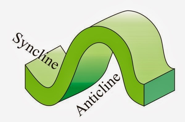
The rock was formed in layers, with a mixture of sea-based fauna and sediments (sand, mud, and corals, etc.), being the sediments within this rock. Over millions of years, heat and pressure has turned the sediments and the creatures they contain into layers of sedimentary rock. This can be envisaged as a layered birthday cake, the cake being made ‘base-up’, so making the basal layer the oldest layer, younging upwards as one moves to the upper layers. Millions of years ago, as the Alps formed away to the south, this area of present southern England was subjected to massive forces, buckling the horizontally-laid layers of rock, making them form 'fold structures'. Imagine a rug laying flat on the floor – push the ends towards each other and the rug will ‘buckle’ and create folds. Folds that hump upwards are termed ‘anticlines’. Folds that buckle downwards are called ‘synclines’.
Cross-Sectional Diagram of a Syncline and an Anticline
If one took a knife and could slice Southern England from South to North, from Havant (a town to the South of Butser), northward to London, you would see this view:
S-N Geological Cross-Section from Havant to London
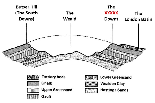
QUESTION 3 - Butser Hill forms part of the South Downs. Is this the southern tip of a syncline or an anticline, and what regional (and geological and geographical) name does the equivalent 'other half' of this structure have?
QUESTION 4 - Using the ‘birthday cake’ model of the layering in sedimentary rocks, and remembering the scale of the above diagram, what layer of rocks do you think the town of Petersfield is built upon, and are these rocks older or younger than the Chalk? ?
The above diagram is only a representation of the topography of the area but it does show the difference in the angles of the slopes of the hills (albeit not accurately). As you stand on the summit of Butser Hill, you will clearly see the slopes of the hills in the surrounding area being like those in birthday cake, but tilted so they ‘dip’ gently from the north to the south. Look to the east and the west, and you will look along the steeper-angled famous 'scarp slope' of the South Downs.
QUESTION 5 – As you look eastwards along the scarp slope, what angle does this slope present, and would you like to sledge down it?
QUESTION 6 - Please add a photograph of yourself/your GPS etc., taken at GZ, with the view behind you, but the photo NOT giving away any answers.
Once you have all the information for the above Tasks and questions, please send me your answers via email or through the Message Centre before logging your visit. I endeavour to respond ASAP, however if I have not within 48 hours, please do email again. I do read every communication I receive, and will delete Logs that do not have a matching set of answers and/or do not adequately answer the set Tasks.
Any Logs without the required photo will be deleted without warning. Group Logs will not be accepted and will also have Logs deleted without notice.
Please feel free to add photos with your log, but please, do not post any photos that give away any of the answers, thank you.