Jonnie's Knob, just south of here, is the terminus of Paddy Mountain. This area features spectacular cliffs and rock outcroppings and its primary features include Dog Cliff and Cove Run. The area's steep ridges create numerous small intermittent streams on the high side slopes. Only near the bottom of the steep slopes is it possible to see year round flow. Many geological factors had to align, over hundreds of millions of years, for this spring to flow today. Read the information below to better understand how that came to be, make some observations about the area, and then submit your responses for a smiley.
The Big Picture - The Ridge-and-Valley Appalachians, also called the Ridge and Valley Province or the Valley and Ridge Appalachians, are a physiographic province of the Appalachian mountains which run from New York to Alabama. These mountains are characterized by long, even ridges and long, continuous valleys, reminding some folks of corduroy when viewed from a great altitude. These curious formations are the remnants of an ancient fold-and-thrust belt. Here, sedimentary strata have been folded westward, and forced over massive thrust faults. As a result, there is little metamorphism, and no igneous intrusion. Well-developed karst topography is present, with many caverns and subsurface channels located in the area. This area contains the oldest rocks in the state from the Davonian-Mississippian era, making the rocks 330+ million years old. 
Local geology and groundwater - Different types of rock vary considerably in their ability to absorb, store, and yield water. Frederick County is underlain by sedimentary rocks which were deposited in ancient seas. These rocks contain water in voids, bedding planes, fractures and solution channels. The predominant rock types in the county are limestone, dolomite, shale, sandstone, and unconsolidated sand and gravel. Limestone and dolomite are sometimes referred to as "carbonates." Large solution openings, which are produced when part of the rock is dissolved by groundwater, are common in carbonate rocks. These openings store and transmit large quantities of water.
Anticlines (up-folds in the rock strata) may bring good water-bearing beds near the surface along their axes. Similarly, synclines (down-folds) may bring water-bearing unties near the surface on the flanks. The axial portion of a syncline can act as a collection area, and, if tapped may yield significant quantities of water under high pressure. Water may flow under its own pressure to, or above, the land surface. When this occurs the well is termed "artesian". A spring occurs when the land dips below the water table level. An artesian well occurs when water flows to the surface naturally due to being pushed up from underground rock pressure.

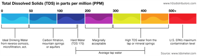
What is TDS? - Total dissolved solids or TDS is a measure of the combined content of all organic and inorganic substances suspended in a liquid. The principal application of TDS is in the study of water quality, although TDS is not generally considered a primary pollutant (e.g. it is not deemed to be associated with health effects) it is used as an indication of aesthetic characteristics of drinking water and as an aggregate indicator of the presence of a broad array of chemical contaminants. A local consumer of the water tested it (UNOFFICIAL) and estimated the TDS to be somewhere between 4 and 12 parts-per million (PPM).
To log this earthcache, email me (through my geocaching.com profile) the answers to the following questions. I will respond if there are any issues.
Question 1: What type of rock is most common in this area? Does this type of rock lead to large or small amounts of groundwater storage and transmission?
Question 2: Is this an artesian well, or a natural spring? Why?
Question 3: What is the TDS range mentioned above? If a typical water system is recommended to have somewhere between 50-350 ppm TDS, would this qualify?
Question 4: Estimate the flow of the area today (helpful hint, bring a milk jug, or something more substantial if you're so inclined, and perhaps a small flexible hose segment). Send me that number and tell me whether the flow is A) less than 3-5 gallons per minute, which is the recommended flow rate for a well in the area. B) over 50 gallons per minute, which makes it one of the more prodigious springs in the state. or C) Somewhere in between those.
Question 5: Which direction is the pipe oriented (e.g. NNE)? Alternately, if you were using the pipe to project a waypoint, what would be the bearing?
Optional: Add pictures to your log of some of the scenery around here (perhaps even you sampling the goods!). Frederick County and the surrounding areas are certainly breathtaking