 For 100 years, the National Park Service has preserved America’s special places “for the enjoyment, education, and inspiration of this and future generations.” Celebrate its second century with the Find Your Park GeoTour that launched April 2016 and explore these geocaches placed for you by National Park Service Rangers and their partners.
geocaching.com/play/geotours/findyourpark
The Assateague Island National Seashore Visitor Center is open 9am to 5pm, daily except for Thanksgiving Day and Christmas Day. During January and February, the visitor center is closed on Tuesdays and Wednesdays. The visitor center hosts aquariums, a touch tank, exhibits, maps and a film about the island's wild horses. There is no fee to enter the Visitor Center.
THIS EARTHCACHE IS NOT AT THE VISITOR CENTER, BUT IS 3-1/2 MILES AWAY.
THERE IS A FEE TO ENTER THE EARTHCACHE AREA IF YOU ARE IN A VEHICLE.
YOU MAY WALK OR BIKE TO THE EARTHCACHE FOR FREE.
FEE INFORMATION
To claim a find you must email your answers for the following questions to us through our profile page. The answers to the questions may be found in the text and on a descriptive sign (at the listed coords) on a raised walkway on the beach at the Assateague Island National Seashore.
1) Name the process that is causing the island to move from east to west. _________________.
2)(a) Which way is it growing? _______________.
(b) Why? ____________________________________.
3) What might block the flow of sand to some places along the Assateague shoreline?
___________________________________________________.
4) According to the sign, why might you see clam and oyster shells on the beach?
______________________________________.
5) Take the walkway toward the ocean. Look closely at the beach to your right and left.
(a) Other than the walkway, what to you see that is manmade?______________.
(b) What is its purpose? ________________________.
(c) Is it working? How do you know? __________________________.
6) With respect to water's edge, estimate the height of nearby dunes. ______________________.
********** END OF QUESTIONS **********
Barrier islands like Assateague are long, low, narrow islands made of sand that form in shallow waters along a coast. Unlike an island made of rock, a barrier island constantly shifts and reshapes itself.
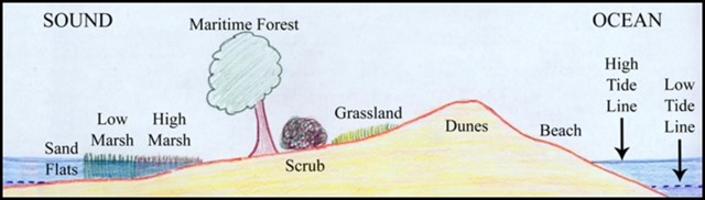
Barrier Island
Longshore currents transport sand south along the beach. Wind and waves deposit sand inland in overwash fans or completely across to the bay. Through this process, called "rollover", Assateague is slowly moving west and growing south.
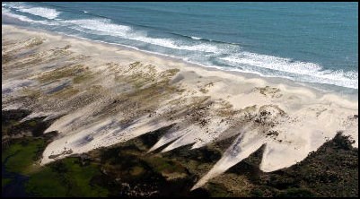
Overwash
In 1964, the National Parks Association, the leading conservation group that lobbied for minimal development of Assateague, concluded that whether by private development or Federal ownership, "long stretches of Assateague Island's Atlantic frontage will require beach erosion control and dune stabilization work." 1
The national seashore was created in 1965 to preserve this constantly changing landform.
In 1970 a report from the University of Maryland's Natural Resources Institute cited findings that concluded that "sand fences and properly cultivated vegetation were economical and effective for dune rebuilding", but another report, prepared for the chief scientist of the National Park Service on Atlantic national seashores, "characterized the barrier islands as inherently dynamic and unstable" and said that "attempts to artificially stabilize them by dune building were not only doomed to failure but were ecologically harmful [because] to the extent that the dunes held and prevented periodic overwash, they impeded the natural formation of salt marsh on the bayside, again adversely affecting productivity." 1
In 1971 the Corps of Engineers found the island to have 22 miles of shoreline subject to critical erosion averaging three feet per year, but the 1970 report raised serious questions about attempting to stabilize the island by dune building.
In 1973 NPS Director Ronald H. Walker announced new National Park Service policies that acknowledge that barrier islands are transient and recommended avoiding permanent development and roads that parallel the seashore.
Today, development on the national seashore is limited to campgrounds, two buildings – one moveable and the other permanent, and four ‘major’ paved roads. The National Park Service did continue limited dune building where necessary to extend the life of its few facilities on the island. Dunes may be built up by the use of sand fences and can be maintained by the use of vegetation and walk-over structures so as to prevent destruction of vegetation that holds sand in place. A sand fence is a fence, usually made of wood, set up in the dunes to trap blown sand. Eventually much of the fence is buried, helping to create dunes. 2
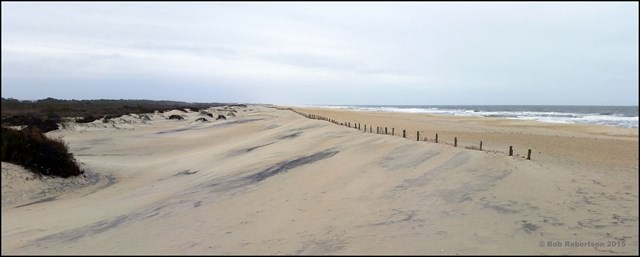
Sand Fence
At the request of National Park Service the Army Corp of Engineers developed a plan to replenish sand at the receding north end of Assateague, and repeat this every three years. "This proposed exception to the general hands-off policy was justified on the grounds that the recession is man-caused (from the Ocean City Inlet jetties blocking the flow of sand to the north end of Assateague) and therefore requires human remediation." 1
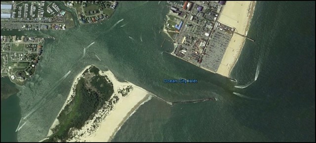
Assateague Island Movement At The Ocean City Inlet
"Assateague Island's broad, gently sloping beach is one of the finest on the East Coast because it is allowed to move naturally with the currents and storms of the Ocean. Ocean City, anything but natural and constrained by economics not to move, pays dearly to retain its beach because densely packed buildings have caused erosion to accelerate. We might say that Ocean City is worth billions of dollars and costs billions of dollars; the beach of Assateague is free and priceless." 3
1 http://www.nps.gov/asis/learn/management/upload/asisadminhistory.pdf
2 Living with the Chesapeake Bay and Virginia's Ocean Shores, Larry G. Ward Durham and London, Duke University Press, 1989, 51
3 John Means, Roadside Geology of Maryland, Delaware and Washington, D.C., (Missoula, Montana: Mountain Press Publishing Company, 2010), 239