 For 100 years, the National Park Service has preserved America’s special places “for the enjoyment, education, and inspiration of this and future generations.” Celebrate its second century with the Find Your Park GeoTour that launched April 2016 and explore these geocaches placed for you by National Park Service Rangers and their partners.
geocaching.com/play/geotours/findyourpark
The Visitor Center is open 9am to 4pm, daily except for Thanksgiving Day and Christmas Day. During January and February, the visitor center is closed on Tuesdays and Wednesdays. The visitor center hosts aquariums, a touch tank, exhibits, maps and a film about the island's wild horses. There is no fee to enter.
While doing this Earthcache, you may want to find the answers to GC66KTM ASIS: Assateague Island National Seashore CAM 2016
To claim a find you must email your answers for the following questions to us through our profile page. The answers to the questions may be found on a descriptive sign at the Assateague Island National Seashore Visitor Center (at the listed coords), on a sign at Reference Point 1, and in the text. The signs are within walking distance and there is no fee to reach them. .
Post a photo of yourself near the signs on the bridge with Ocean City in the background.
AT THE LISTED COORDS: [N38 14.854 W075 09.288] Caring for the Bay
1 The health of the marshes and the ocean, and by extension the vegetation that contributes to the stability of the island, is dependent on the health of the bays.
How many square miles of land drain into the bays? ________.
AT REFERENCE POINT 1: [N38 14.742 W075 08.986] Island On The Move
Observe the width of Sinepuxent Bay on both sides of the bridge. Like most barrier islands, Assateague is slowly moving westward.because of a natural process called rollover. Until 1935 the island moved westward at a rate of 3 feet per year
2 Use 5,280 feet as the width of the bay and a rate of 3 feet per year to calculate how many years it would have taken for the island to touch the mainland.
Number of years = 5,280 divided by 3 = ________
3a Something happened here in 1933. What was that event? _________________
3b What did it form? ________________________
3c What man-made objects were created to keep it open? _______________
3d What was the effect on western migration? __________________
4 Since 1935 the new rate of movement is 35 feet per year. Use 5,280 feet as the width of the bay and a rate of 35 feet per year to calculate how many years it might take for the island to touch the mainland.
Number of years = 5,280 divided by 35 = _____________
5a FROM THE TEXT What was the name of the Project implemented in 2002? ___________________________
5b What was its purpose? ____________________________________
Before leaving the bridge look north toward Ocean City.
6a Where do the buildings and structures appear with respect to Assateague Island?
______________________________________________________.
6b Why do you think this is? ___________________________________.
********** END OF QUESTIONS **********
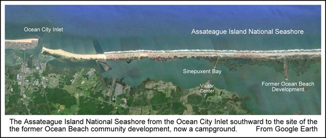
Most of us envision the seashore as a place where the bedrock of the area slopes down to the sea and is covered by sand and small pebbles that are continually renewed by wind and wave action. The portion of the Atlantic Coast of the Delmarva Peninsula known as Assateague Island National Seashore "is not part of the mainland like the beaches of the Pacific Coast, but rather [part of] a barrier island stretching 60 miles from a headland at Rehoboth Beach, Delaware, to near Chincoteague, Virginia, just south of the Maryland state line. Barrier islands are long, narrow ridges of sand that parallel the mainland coast but are separated from it by shallow lagoons or bays. In their natural state, these islands have relatively wide beaches backed by sand dunes. Most of the dunes are no more than 20 feet high." 1
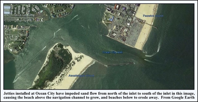
"The northern 10 miles of Maryland's barrier island is called Fenwick Island, but most vacationers know it as Ocean City, a heavily urbanized beach resort that with the condos, hotels and amusements is more concrete and asphalt than dunes and beach. At [Fenwick] Island's southern end is the Ocean City Inlet, a storm-punctured break in the island kept open by jetties to provide access to the ocean for recreational and commercial watercraft. The southern 20-plus miles of the island in Maryland is Assateague Island, a mostly natural barrier island that is a national and state park." 1
Fifty years ago those who wanted to preserve Assateague in its natural state for public enjoyment were losing to commercial developers committed to developing "Ocean Beach" as an equal of nearby Ocean City. Land was divided into thousands of lots and were slated for development along a fifteen mile road named Baltimore Boulevard, and plans were underway for dredging and filling wetlands. These activities, along with changes to the shoreline such as seawalls and groins would undoubtedly destabilize the fragile island. Development would also "limit the island’s usefulness in protecting the mainland coast from powerful storms as well as eliminate important ecosystems, such as dunes and salt marshes." 2
Then, in 1962, a severe storm destroyed almost half of the 30 houses standing in Ocean Beach and damaged the rest. Only about 16 cottages, 17 gun clubs, and a few other buildings remained in the Maryland portion, many of them older structures on the relatively sheltered bay side outside the Ocean Beach subdivision. 3 While developers were reeling from their losses the U.S. Army Corps of Engineers declared Assateague unsuitable for development. In 1965 Assateague Island was designated a National Seashore as part of the National Parks system and restoration began.
Even though Assateague had escaped the environmental consequences of the proposed Ocean Beach development, the northern five or six miles of the island were migrating west at an accelerated rate because of sand deprivation caused by the jetties on the beaches of Ocean City and at the inlet. A jetty (or groin) is a structure perpendicular to the beach that is designed to interrupt and trap the longshore flow of sand. Sand accumulates on one side of the jetty (updrift accretion) at the expense of the other side (downdrift erosion). If the current direction is constant all year long, a jetty "steals" sand that would normally be deposited down the beach. The amount of sand on the beach does not change, but erosion now happens further down the beach. 4
Ocean City's efforts to keep the southern end of Fenwick Island stable by adding sand and building jetties have hastened beach erosion on Assateague.
The ocean shoreline near where you are is far enough south of the Ocean City Inlet's jetties to receive sand flowing down the coast by Ocean City, so from here to the south end of Assateague the island moves only a few feet per year, which is normal for a healthy barrier island.
In 2002 the North End Sand Bypass Project was implemented to slow the westward movement of the north end of Assateague below the inlet by replenishing sand and sediment on a regular basis.
"Assateague Island's broad, gently sloping beach is one of the finest on the East Coast because it is allowed to move naturally with the currents and storms of the Ocean. Ocean City, anything but natural and constrained by economics not to move, pays dearly to retain its beach because densely packed buildings have caused erosion to accelerate. We might say that Ocean City is worth billions of dollars and costs billions of dollars; the beach of Assateague is free and priceless" 1
1 John Means, Roadside Geology of Maryland, Delaware and Washington, D.C., (Missoula, Montana: Mountain Press Publishing Company, 2010), 239
2 http://www.smithsonianmag.com/science-nature/building-on-a-barrier-island-65387317/
3 http://www.nps.gov/asis/learn/management/upload/asisadminhistory.pdf
4 http://www.beachapedia.org/Shoreline_Structures