(ENGLISH BELOW)
IL FIUME ARNO
L'Arno è il maggior fiume dell'Italia peninsulare dopo il Tevere e il principale corso d'acqua della Toscana.
Ha una lunghezza totale di 241 km, un bacino di 8.228 km² e una portata media annua presso la foce di circa 110 m³/s. Nasce sul versante meridionale del Monte Falterona, nell'Appennino tosco-romagnolo, a quota 1.358 m sul livello del mare, e sfocia nel Mar Ligure poco dopo aver attraversato Pisa.
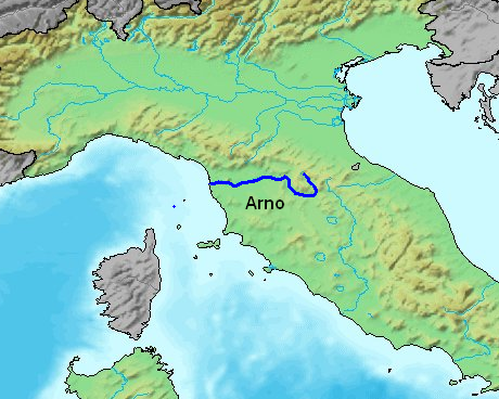
La sorgente dell'Arno, detta Capo d'Arno, si trova nel comune di Pratovecchio Stia in provincia di Arezzo. Presso San Giovanni Valdarno, ultimo comune aretino, entra in provincia di Firenze, uscendone presso Fucecchio. Da qui scorre in provincia di Pisa fino alla foce.
Il suo ampio bacino raccoglie le acque di vari sottobacini:
- il Casentino, costituito dall'alto bacino dello stesso Arno fino alla confluenza con il canale Maestro della Chiana;
- la Val di Chiana, piana bonificata nel XVIII secolo e in precedenza paludosa, tributaria anche del fiume Tevere;
- il Valdarno superiore, una lunga valle delimitata a destra dal Pratomagno e a sinistra dai rilievi della provincia di Siena;
- il sottobacino della Sieve, principale tributario dell'Arno che vi confluisce poco prima di Firenze;
- il Valdarno medio, che si estende dalla confluenza della Sieve fino alla confluenza con l'Ombrone pistoiese, include la piana di Firenze, Sesto Fiorentino, Campi Bisenzio, Prato e Pistoia;
- il Valdarno Inferiore, caratterizzato da vallate in cui scorrono numerosi affluenti importanti come la Pesa, l'Elsa e l'Era; a valle di Pontedera l'Arno scorre poi verso la foce ad un livello più elevato rispetto alla pianura circostante.
I principali affluenti dell'Arno sono:
da destra:
- Sieve
- Bisenzio
- Ombrone pistoiese
- Pescia
- Usciana
da sinistra:
- Canale Maestro della Chiana
- Greve
- Pesa
- Elsa
- Ambra
- Era
- Vingone
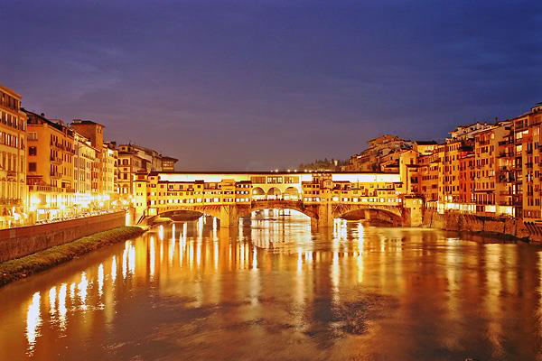
Lungo il suo percorso attraversa diverse città e paesi, le più importanti sono Firenze, Empoli, Fucecchio, Santa Croce sull'Arno, Pontedera, Cascina e Pisa

COME LOGGARE LA CACHE:
Dovrete rispondere alle seguenti domande per poi mandare le risponde al mio account privato.
- Qual è la lunghezza totale del fiume? E il suo bacino?
- Dove si trova la sua sorgente?
- Da quali bacini raccoglie l'acqua? Ne elenchi almeno 4?
- Da quanti affluenti prende le acque da destra? E da sinistra? Ne elenchi almeno 5? (destra o sinistra)
Recati al GZ, raccogli le informazioni necessarie per poter rispondere alle seguenti domande:
- Quanto misura la distanza tra una sponda e l'altra?
- A che altezza ti trovi dal fiume?
- Quant'è la velocità del fiume? (puoi recarti in un altro punto per misurarla, come per esempio il Waypoint Measurements)
ENGLISH
ARNO RIVER
The river is the biggest river in Peninsular Italy after the Tiber and the main watercourse of Tuscany.
It has a total length of 241 km, a drainage basin of 8228 km ² and an annual average flow at the mouth of about 110 m/s ³ was born on the southern slope of Mount Falterona, tosco-romagnolo Apennines at an altitude of 1358 m above sea level, and flows into the Mediterranean Sea shortly after crossing Pisa.

The source of the River Arno, called Capo d'arno is located in the
municipality of Pratovecchio Stia Arezzo. At San Giovanni Valdarno,
Arezzo, enters the last municipality in the province of Florence, exit at Fucecchio. From here it flows in the province of Pisa to the mouth.
Its large reservoir collects the waters of various sub-basins:
-
the Casentino, the upper basin of the same Arno River to its confluence with the canale Maestro della Chiana;
-
the Val di Chiana, reclaimed plain in the 18th century and earlier, also tax wetland of the River Tiber;
-
the upper Valdarno, a long Valley bordered on the right by the Pratomagno and left by the mountains of the province of Siena;
-
the Sub-basin of the Sieve, the Arno's main tributary that flows just before Florence;
-
the Middle Valdarno, which extends from the confluence of the Sieve to its confluence with the Ombrone pistoiese, includes the Florence, Sesto Fiorentino, Campi Bisenzio, Prato and Pistoia;
-
the lower Valdarno is characterised by valleys in which numerous tributaries such as the Pesa, Elsa and Era; in the Valley of the Arno in Pontedera then flows to the mouth at a higher level than the surrounding plain.
The main tributaries of the River are:
from the right:
-
Sieve
-
Bisenzio
-
Ombrone pistoiese
-
Pescia
-
Usciana
from left:
During its route it passes through several cities and towns, the most
important are Florence, Empoli, Fucecchio, Santa Croce sull'arno, Pontedera, Cascina e Pisa.
You have to answer the following questions then send responds to my private account.
-
What is the total length of the river? And its watershed?
-
Where is its source?
-
Which collects water basins? It lists at least 4?
-
How many tributaries takes water from right? And from the left?
-
It lists at least 5? (left or right)
Go to GZ, get the information you need to answer the following
questions:
-
Measures the distance between one side and the other
-
At what height you are by the river?
-
What is the speed of the river? (you can go somewhere else to measure it, as for example the Waypoint Measurements)