HR
Geološki park Fantazija Monfiorenzo ima radno vrijeme; 10-18 sati
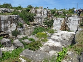
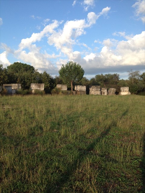
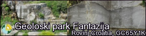
U blizini Rovinja, uz cestu Rovinj – Pula, u području koje se naziva Monfiorenzo nalazi se kamenolom Fantazija, a koji još i nazivaju Cava di Monfiorenzo.
Kamenolom je 1987.godine proglašen geološkim spomenikom prirode jer lokalitet predstavlja jedinstven primjer sedimentologije vapnenca, te je po mišljenju znanstvenika jedan od najznačajnijih spomenika prirode na svijetu kad se govori o kraškom fenomenu, a i jedan je od najintersantnijih kamenoloma na svijetu. Geološki park je od velike važnosti i ljepote, a prostire se na površini od 4 hektara.
Stijene kamenoloma mogu nam dočarat povijest razvitka zemljine kore i ujedno služe za znanstveno objašnjenje postanka sličnih stijena diljem svijeta. Zašto? Jer slične stijene diljem svijeta sadrže samo neke dokaze i pokazatelje takvog tipa postanka, a u kamenolomu Fantazija možemo ih naći sve. Tijekom mezozoika Istra je bila dio Jadranske karbonatne platforme gdje su se u plitkom i toplom moru taložile karbonatne stijene.
Na prijelazu iz jure u kredu dolazi do globalnog sniženja morske razine te stoga na području platforme dolazi do isparavanja, stvaranja pukotina u talogu i do dolomitizacije vapnenaca.
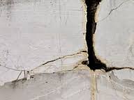
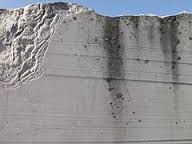
Ako pažljivo gledate stijene otkrit ćete niz brazdi stvorenih od crno bijelih slojeva dolomita, a možete i uočiti pukotine koje su nastale stezanjem i isušivanjem mulja, a koji se utisnuo u već stvoreni sediment.
Kamenolom Fantazija je standard svim ostalim nalazištima stijena istog tipa iz razloga što su u njemu vidljivi slojevi genetski različitih tipova dolomita s očuvanim detaljima teksture, koji ukazuju na procese djelatnosti modrozelenih algi, okamenjivanja šupljinica nastalih truljenjem algi, oscilacija morske razine, izmjenu plime i oseke, uzastopna vlaženja taloga morskom vodom i njegova isušivanja.
Mnogi slojevi svjedoče o postojanju okamenjenih livada sačinjenih od modrozelenih algi koje su, pomiješane s vapnenačkim muljem, bile nanašane tijekom 130 milijuna godina na kopno snagom morskih struja.
Da bi mogli logirat Earthcache postavit ću Vam nekoliko pitanja, a Vi mi pošaljite odgovore na mail, ne morate čekat moj odgovor već slobodno logirajte, ako nešto nije u redu kontaktirat ću Vas.
1. Na kamenom bloku (Stage 1) možete vidjet tamne i svjetle slojeve, kako objašnjavate tamne slojeve?
2. Pažljivim promatranjem možete vidjeti i sitne pukotine objasnite kako su one nastale?
3. U koju skupinu spadaju dolomit i vapnenac?
4. Koliko dugo su nanašane modrozelene alge pomiješane sa vapnenačkim muljem na kopno?
5. U log stavite sliku sebe (fotografijom na kojima je gps/mobitel, ruka ili noga NE ispunjavate zadatak i log će biti obrisan)ili papira s vašim nikom ispred table sa Spoiler fotografije.(Nemojte slikati kamene blokove izbliza!)
Uživajte u ovom posebnom earthcachu koji je od velike važnosti.
EN
The geological monument of nature Fantazija Monfiorenzo is opening; 10-18 hour
Near the City Rovinj on the road Rovinj – Pula, in an area which called Monfiorenzo is the querry Fantasy, which also known as Cava di Monfiorenzo.
The querry was declared as a geological monument of nature in 1987., because he is a unique example of limestone sedimentology and the opinions of scientists it is one of the most significant nature monuments in the world in the perspective of the karst phenomenon and one of the most interesting querries in the world. Geological park of a remarkable importance and beauty, and covers an area of 4 hectares.
The stone of the quarry illustrate the history of the evolution of the earth crust and are also used for scientific explanation of the foundation of similar rocks around the world. Why? Because the similar rocks around the world have only some evidence and indicators of such emergence type and in the querry phantasy we have all of them. During the Mesozoic era, Istria was a part of the Adriatic carbonate platform for depositing carbonate rocks in its shallow and warm sea deposited carbonate rocks.
During the transition from the Jurassic into the Cretaceous period it comes to the global lowering of the sea level and thus on the platforma rea comes to evaporation, creating cracks in the sediment and to limestone dolomitisation.
If you look carefull the rocks you will discover manny of furrows made of black and white dolomiti layers and you can spot fissures formed by tightening and exsiccation of the silt that had been pressed into the previously created sediment.
Querry Fantasy represents the standard for all other rock sites of such emergence type because in it is visible layers of genetically various dolomite types with preserved textural details, indicating blue-green algae activity, the fossilization of cavities emerged due to rotting algae, the sea level oscillations, tide and ebb exchange, successive deposit sea water damping and its drying up.
Various layers give evidence of the existence of the the fossilized meadows consisting of sea-weads, which, blanded with lime-stone silt, were drifted on the shore by strong currents during the last 130 million years.
In order to log this EarthCache I will ask you several questions and you should send your answers to my e-mail. You don’t have to wait for my confirmation, feel free to log the find as son as you send your answers. If there are problems with your answers, I will contact you.
1. On the stone block (Stage 1) you can see dark and light layers such explaine you the darker layers ?
2. If you watched carefully you can see fissures explain how they formed?
3. In which group include dolomite and limestone?
4. How long have drifted blue – green algae mixed with limestone silt on the shore?
5. To the log put a picture of yourself (photo showing a GPS/mobile phone, hand or leg do NOT fulfill the task and the log will be deleted)or paper with your nick in front of the board from the Spoiler photo.(Don't take pictures of stone blocks from close up!)
Enjoy in this special Earthcache which is of a great importance.
DE
Der geologischen Naturdenkmal park Fantazija Monfiorenzo hatt öffnungszeit; 10-18 uhr
In der Nähe der Stadt Rovinj auf der Straße Rovinj – Pula, im Gebiet von Monfiorenzo, befindet sich der Steinbruch Fantasia, der auch als Cava die Monfiorenzo bekannt ist.
Der Steinbruch wurde im Jahr 1987 zum geologischen Naturdenkmal erklärt, denn er ist ein einzigartiges Beispiel der Sedimentologie von Kalkgestein. Die Wissenschaftler erklären, dass er einer der bedeutendsten Naturdenkmäler der Welt aus Sicht des Karstphänomens und gleichzeitig einer der interessantesten Steinbrüche in der Welt ist. Der geologische Park ist von einer bemerkenswerten Bedeutung sowie Schönheit und erstreckt sich über eine Fläche von 4 Hektar.
Die Felsen des Steinbruchs gewähren uns Einblicke in die Entwicklungsgeschichte der Erdkruste und dienen zur wissenschaftlichen Interpretation der Entstehung von ähnlichen Gesteinen in der Welt. Warum? Weil ähnliche Felsen auf der ganzen Welt nur einige Hinweise und Indikatoren eines solchen Entstehungstyps besitzen, aber im Steinbruch Fantasia sind sie alle zu finden. Während des Mesozoikums war Istrien ein Teil der adriatischen Karbonatplattform, wo sich im seichten und warmen Meer Karbonatfelsen abgelagert haben.
Während des Übergangs von Jura zur Kreidezeit kam es zur globalen Senkung des Meeresspiegels. Daher kam es auf dem Gebiet der Plattform zum Verdunsten des Wassers, wodurch es in Folge zur Bildung von Rissen im Sediment und zur Dolomitisierung des Kalkgesteins kam.
Wenn Du Dir die Felsen genau anschaust kannst Du eine Vielzahl von Rissen erkennen die sich durch die schwarz/weißen Dolomitschichten ziehen. Außerdem kann man auch Risse sehen, die sich durch das Zusammenziehen und Austrocknen von Schlamm in das schon entstandene Sediment gedrückt haben.
Der Steinbruch Fantasia gilt als Standard für alle anderen Gesteinfundstellen dieses Entstehungstyps, da in ihm Schichten von genetisch verschiedenen Arten Dolomitgesteins mit erhaltenen Texturdetails sichtbar sind. Ein Hinweis auf die Aktivität der blaugrünen Algen, die Versteinerung von kleinen Hohlräumen durch Verrottung von Algen, die Schwankung des Meeresspiegels, den Wechsel von Ebbe und Flut, sowie die aufeinanderfolgende Befeuchtung des Sediments mit Meereswasser und seine Austrocknung.
Viele Schichten zeugen von versteinerten Wiesen aus blaugrünen Algen, die vor 130 Millionen Jahren gemeinsam mit Kalkschlamm durch kräftige Meeresströmungen an die Küste transportiert wurden.
Zum Loggen dieses Earthcaches habe ich ein paar Fragen an Dich. Bitte die Antworten an meine E-Mail Adresse schicken. Du musst nicht auf meine Antwort warten, sondern kannst gleich loggen. Wenn etwas nicht korrekt ist werde ich Dich kontaktieren.
1. Auf dem Felsblock (Stage 1)kann man dunklere und helle Schichten erkennen, wie erklärst Du Dir die dunkleren Schichten?
2. Wenn Du den Felsblock sorgfältig beobachtest kannst Du winzige Risse erkennen. Erkläre wie sie entstanden sind?
3. In welche Gruppe gehören Dolomit und Kalkstein?
4. Wie lange wurden die blaugrünen Algen mit dem Kalkschlamm durch kräftige Meeresströmungen ans Land getrieben?
5. Zum Log ein Bild von Dir (Foto das ein GPS/Handy, Hand oder Bein zeigt, erfüllen NICHT die Aufgabe und werden gelöscht)oder Papier mit Deinem Nick vor der Tafel vom Spoilerfoto hochladen.(Steinblöcke nicht aus der Nähe fotografieren!)
Genieße diesen speziellen Earthcache der von großer Bedeutung ist.
Ich möchte mich sehr herzlich bei Red_family für die Unterstützung und Hilfe bedanken.
Zahvaljujem se GC Edo na pomoći i korisnim savjetima.
Vielen lieben Dank an jongletti für die Korrektur des deutschen Textes.
Souvenir/Banner
Code: <a href="http://www.geocaching.com/seek/cache_details.aspx?wp= GC65Y1K" target="_blank"><img src="http://img.geocaching.com/cache/large/d44e5962-9a46-40a8-bbb4-91f0cdfba6ed.png
"></a>