Lake Karakul
Lake Karakul ("black lake") in the Pamir mountains of Tajikistan in Central Asia is one of the highest lakes in the world; higher than lake Titicaca in Peru and within its class of surface size it is possibly the highest lake on Earth altogether. Having it's origin in a meteorite impact some 25 million years ago, it is also the highest located impact structure known so far.
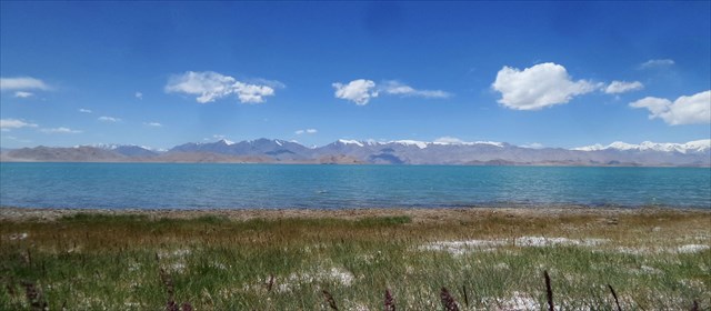
Set against a background of mountains more than 6.000m high and clear skies in unbelievable colours this is one of the top locations on earth with a unique geological feature that does deserve an Earthcache.
Today it is well accessible by road from Kyrgistan in the North, making it a prime attraction for backpackers, adventurers and globe trotters. Still, it takes some time and preparation to get there, reflected in a D/T rating of 3/3 for a cache that would be rated 1/1,5 in a region such as Montana or Switzerland. So once you reach the high plateau things are easy.
Geologic profile
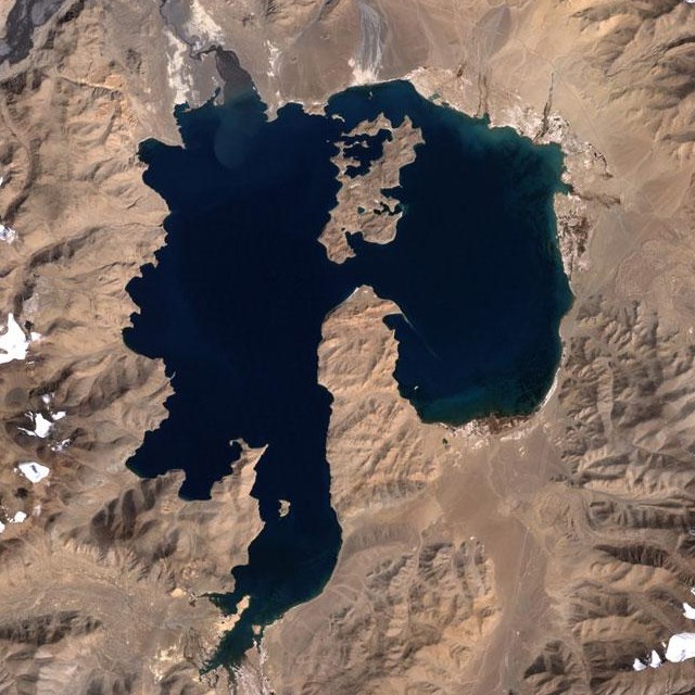
Lake Karakul is a closed-basin lake at3928 m above sea level (asl) in the eastern Pamirs, a mountain range between the Tienshan in the north and the Karakorum (westernmost Tibetan Plateau) in the south. The lake fills the central part of a basin ca. 52 km in diameter has originated from a meteorite impact in the late Neogene (Gurov et al., 1993). An island in the northern part of the lake and a peninsula in its southern half are interpreted as central uplift of the impact structure. A tectonic origin of the lake also has been proposed but meanwhile, the meteorite origine has been confirmed with imagery from space.
Mountains in the catchment area rise to ca. 5300 m asl with the highest peaks above 6000 m asl. Many of the surrounding mountain ridges are covered by snow and ice which are the most important sources of the lake water. Sands and gravels of large alluvial plains and fans in the north, east and south of the lake probably accumulated in the Quaternary. Gurov et al. (1993) mapped lacustrine sediments in the northeast of the lake regarded as PlioPleistocene deposits. Glacial moraines and glacially-striated boulders show that Pleistocene glaciers reached the present-day northern lake shore and came close to the eastern shore.
Mountains flank the western shore of the lake. Triassic to Jurassic granitic rocks and metamorphosed Paleozoic sedimentary rocks are exposed in the catchment area. Gurov et al.(1993) reported on shock-metamorphosed and brecciated rocks from the island and northern part of the peninsula in Lake Karakul. The closed-basin lake has a relatively shallow eastern sub-basin with a water depth of ca. 20 m and a deep western sub-basin with a maximum water depth of 242 m. A salinity of 10 g l−1, a summer water temperature of ≤13 °C and a maximum Secchi depth of 19 m were reported for the ultra-oligotrophic lake.
The lake is frozen from the end of November until the end of May with ice of ca. 1 m thickness. A lake level rise by 1.3 m was recorded between the years 1970 and 2001, probably in response to global warming and resulting meltwater discharge.
Green algae and the aquatic macrophytes Potamogeton pamiricus and Chara were recorded from the lake. The fauna includes the freshwater shrimp Gammarus pulex, Radix lagotis as the only mollusc in Lake Karakul, and the Karakul stone loach (Noemacheilus lacus nigri).,
(article taken from: Modern hydrology and late Holocene history of Lake Karakul, eastern Pamirs (Tajikistan): A reconnaissance study; cited by Palaeogeography, Palaeoclimatology, Palaeoecology 289 (2010) 10–24)
The lake is lacking a drainage outlet (endorheic) and as a result the water is brackish. There is a small village with the same name on the eastern shore of the lake. Although the lake lies within a national park, much of the surroundings are used as pasture. The lake, with its islands, marshes, wet meadows, peat bogs, and pebbly and sandy plains, has been identified by BirdLife International as an Important Bird Area (IBA) because it supports significant numbers of the populations of various bird species, either as residents, or as breeding or passage migrants. These include bar-headed geese, ruddy shelducks, common mergansers, saker falcons, Himalayan vultures, lesser sand plovers, brown-headed gulls, Tibetan sandgrouse, yellow-billed choughs, white-tailed rubythroats, white-winged redstarts, white-winged snowfinches, rufous-streaked accentors, brown accentors, black-headed mountain-finches and Caucasian great rosefinches. The lake's islands are the main places where waterbirds rest and nest. (Wikipedia).
Loging requirement
Your task at this place is to answer the following questions:
a) try the lake water and describe its taste, smell and mouth feel.
b) What pH value do you think does it have, rather acidic, neutral or alkaline?
c) close to the posted coordinates you will find a sign with information on Lake Karakul. what are the surface sice and maximum depth of the lake indicated there?
d) looking at the satellite imagery, describe in your own words, why you think this lake has been identified as a complex impact crater
e) not mandatory but always welcome are pictures with or without you.
email me your answers through my profile or to kuschelchen@geocachingweb.de
happy hunting!