Punta Basei 3.338 m Traditional Geocache
-
Difficulty:
-

-
Terrain:
-

Size:  (regular)
Please note Use of geocaching.com services is subject to the terms and conditions
in our disclaimer.
Punta Basei 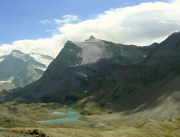
 La Punta Basei è una montagna delle Alpi Graie alta 3.338 m s.l.m. collocata tra la Val di Rhêmes (Valle d'Aosta) e la Valle Orco (Piemonte). Dal versante piemontese domina il lago Serrù ed il lago Agnel. La Punta Basei è una montagna delle Alpi Graie alta 3.338 m s.l.m. collocata tra la Val di Rhêmes (Valle d'Aosta) e la Valle Orco (Piemonte). Dal versante piemontese domina il lago Serrù ed il lago Agnel.
È possibile salire sulla vetta partendo dal rifugio città di Chivasso situato al Colle del Nivolet o poco oltre dal rifugio Savoia al Pian del Nivolet oppure dal lato valdostano partendo dal rifugio Benevolo situato nella testata glaciale della Val di Rhêmes.
La vetta è estremamente panoramica a 360° con viste mozzafiato sul Gran Paradiso e sulle montagne ed i ghiacciai della Val di Rhemes oltre che sulle cime canavesane, savoiarde e valdostane ed i sottostanti laghi Serrù, Agnel, di Ceresole.
Accesso: In Auto passare Ceresole Reale fino al Colle del Nivolet a 2.612 m slm. Da qui si scende verso il versante valdostano, fino a raggiungere i laghi del Nivolet dove si può parcheggiare a bordo strada oppure nei piazzali del Rifugio Savoia.
Il sentiero prende quota tra i prati, e dopo pochi minuti si evita una diramazione verso destra in direzione di un alpeggio (che prosegue per il Taou Blanc e Col Leynir), continuando invece a sinistra che poco dopo attraversa il rio Rosset. Ancora un tratto pianeggiante e si è in vista del lago Leytà.
Qui una freccia indica la deviazione a sinistra per il Colle di Nivoletta e per la Punta Basei (ved ref point).
Difficoltà: L'escursione non presenta particolari difficoltà in assenza di neve, anche se questo percorso è comunque considerato alpinistico.
Fino al Colle Basei il sentiero è su pietraia con evidenti tracce e ometti di pietra.
L'ultimo tratto è in cresta, abbastanza esposta passando al di sopra di ghiacciai e bisogna fare attenzione a dove si appoggiano i piedi.
Poco prima della vetta vi è un breve passaggio di arrampicata con l'ausilio di una corda.
La difficoltà cambia nettamente con la presenza di neve. In questo caso consigliamo massima attenzione ( seriamente!) e l'utilizzo di ramponi e magari anche in cordata.
Durata: 3 ore circa (anche qualcosa in meno) + il ritorno
Buon divertimento, godetevi la gita !
 Punta Basei is a mountain of 3,338 meters above sea level high Graian Alps situated between the Rhêmes Valley (Valle d'Aosta) and Valle Orco (Piedmont). On the Piedmontese side it's overlooking the Serrù lake and the Agnel lake. Punta Basei is a mountain of 3,338 meters above sea level high Graian Alps situated between the Rhêmes Valley (Valle d'Aosta) and Valle Orco (Piedmont). On the Piedmontese side it's overlooking the Serrù lake and the Agnel lake.
You can climb to the summit starting from the refuge city of Chivasso located at Colle Nivolet or a bit further from refuge Savoia at Pian del Nivolet or alternatively from starting from the Benevolo refuge located in the head of the glacial valley of Rhêmes.
The summit is extremely panoramic 360 ° breathtaking views of the Gran Paradiso and the mountains and glaciers of the Val di Rhemes well as on the tops of Canavese, Savoyard and Val d'Aosta and the underlying lakes Serrù, Agnel, Ceresole.
Access: By car pass Ceresole Reale until Colle Nivolet at 2,612 m above sea level. From here you proceed down to the Val d'Aosta side, until you reach the Nivolet lakes where you can park on the roadside or at th eparking lot of the Savoia Refuge.
The trail climbs through the meadows, and after a few minutes near of a mountain pasture continue to the left. Soon you'll cross the Rosset river, then proceed on a flat section until you see lake Leytà.
Here an arrow indicates the deviation to the left for Colle di Nivoletta and the Punta Basei (see reference point).
Difficulty: The hike is not particularly difficult in the absence of snow, although this path is still considered mountaineering trail.
Until Colle Basei the path is on stony ground with clear signs and cairns.
The last stretch is on the ridge, passing quite exposed above glaciers and you have to be careful where you step.
Shortly before the summit there is a short passage of climbing with the aid of a fix rope.
The difficulty clearly changes with the presence of snow. In this case, we recommend extreme caution (!) and the use of crampons and maybe even roped in.
Approx. duration: About 3 hours (even a bit less) + way back.
Enjoy the hike and the views !
 For Nepalese translation please click the flag. Thank you. For Nepalese translation please click the flag. Thank you.
 Pour une traduction française cliquez sur le drapeau. Merci. Pour une traduction française cliquez sur le drapeau. Merci.
 Für eine deutsche Uebersetzung bitte auf die Flagge klicken. Danke. Für eine deutsche Uebersetzung bitte auf die Flagge klicken. Danke.


|
Additional Hints
(Decrypt)
Va han pnivgà qryyn ebppvn, pbcregb qn cvrger.
Va n pnivgl bs gur ebpx, pbirerq jvgu fgbarffrr.
Fcbvyre cvppgher