Reigate's Caves EarthCache
-
Difficulty:
-

-
Terrain:
-

Size:  (other)
Please note Use of geocaching.com services is subject to the terms and conditions
in our disclaimer.
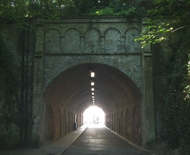
Tunnel Road
Welcome to Reigate.
Reigate is a historic town in Surrey, England. It is in the London commuter belt and one of three towns in the borough of Reigate and Banstead. It is sited at the foot of the North Downs and extends over part of the Greensand Ridge.
Geology

The Greensand Ridge is formed of Lower Greensand, which is predominantly sandstone.
Sandstone is a type of sedimentary rock formed in in the Lower Cretaceous period.
There are two stages in its formation. Firstly, the layers of sand deposited through sedimentation by a river, lake or sea. Secondly, they become compressed by subsequent deposited layers and cemented together by minerals, especially silica, calcites and clays.
The word "sand" in sandstone refers to the particle size of the grains in the rock rather than the material of which it is composed. Sand-size particles range in size from fine (0.06-0.2mm), medium (0.2-0.6mm) and coarse (0.6-2mm) in diameter.
When freshly exposed the sandstone here has a greenish colouration owing to the presence of glauconite, but on exposure to the atmosphere this is rapidly oxidised to limonite, giving rise to a yellow or reddish brown staining.
A Brief History of the ‘caves’
Reigate is well known for its 'caves', which riddle the town centre, but they are in fact largely old sand mines. The castle mound overlooking Reigate town centre is composed of soft sandstone and has been mined over several centuries. The castle has long gone but the mound and many of its excavations still remain.
The Barons' Cave is believed to originate from the 11th Century and was known to exist at the same time as Reigate Castle. Local folklore has it that the barons held a secret meeting at the Barons' cave on their way to Runnymede to sign the Magna Carta.

The Barons' Cave
Tunnel Road was built in 1823 and is now the oldest road tunnel in Britain and one of the oldest in Europe.
The Tunnel Road caves have had many uses during their long existence. The caves found west of the tunnel were originally opened up as sand mines and the caves on the east side were dug specifically for storage including wines and beers.
During the First World War, the tunnels were used to store high explosives in advance of major offences on the Western Front.
During the Second World War they were used as public air raid shelters, where a community of residents slept regularly for many months.
The caves have even been used over the years as a public convenience, shooting club, and a venue for a local band to practice and give concerts.
For further information click here or to visit the caves click here.
Important Information
The co-ordinates for this cache will bring you to the entrance to the tunnel.
To claim this EarthCache as a find please send your answers to me by either using the message centre, or email. All emails should show your caching name (eg terrapintim) and email address and they should be sent to my email through my profile. Your answers should be sent to me BEFORE YOU LOG YOUR FIND, and afterwards you can then log the cache as a find and upload your photo (if you choose to do so). Please DO NOT reveal any of the answers in your log! Finally, you DO NOT have to wait for my reply, as I will contact you if there are any problems with your answers. I will however do my best to respond out of courtesy as soon as possible 
Tasks
1. In which geological period was the sandstone formed?
2. Walk over to the sandstone and examine it. What does it look like? What colour is it?
3. Inspect the sandstone closely. What happens when you touch it? Would you say the grains were fine or coarse?
4. Sandstone is relatively soft and widely used around the world in construction and for artistic purposes. What can you see that backs up this statement?
Optional Task
5. As an optional extra find the old Mead’s Stores Sign at N 51° 14.296 W 000° 12.346, take a photo of you/your GPSr with the sign in the background and post it with your log.
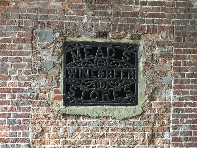
The old Mead’s Stores Sign
Additional Hints
(No hints available.)