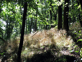
 Une véritable "cache de marche" avec focus absolu sur la qualité de la promenade au lieu de l'ingéniosité de la cache. Distance de la boucle +/- 22 km, dénivelé de 690m, +/- 7 heures de marche. Un arrêt de repos facultatif est prévu après chaque étape de 8 km (cfr point de référence Hotel de la Vallée, Auberge St Martin, Hotel l'Eau Vive).
Extension de 9 km possible avec la série 'les Pont de Nafraiture'. Connection à la question G.
Attention en saison de la chasse, l'accès aux forêts peut être interdite (Octobre, Novembre, Décembre, à contrôler sur internet avant, normalement aussi clairement indiqué le début du sentier).
 Een échte "wandelcache" met absolute focus op de kwaliteit van de wandeling in plaats van de ingeniositeit van de cache. Afstand van de lus +/- 22 km, hoogteverschil van 690m, +/- 7 uur stappen. Een optionele rustplaats is voorzien na elke etape van 8 km (cfr referentiepunten Hotel de la Vallée, Auberge St Martin, Hotel l'Eau Vive).
Uitbreiding met 9 km mogelijk met de serie 'les Pont de Nafraiture'. Verbinding aan vraag G.
Opgelet tijdens het jachtseizoen, toegang tot de bossen is misschien verboden (oktober, november, december, vooraf te controleren op internet, normaal ook duidelijk aangegeven aan het begin van de wandelwegen).
 A real "hikers' cache" with absolute focus on the quality of the hike instead of the ingenuity of the cache. Distance of the closed loop is +/- 22 km, 690m elevation delta, +/- 7 hours hiking. An optional resting place is available after each 8 km stint (see reference points Hotel de la Vallée, Auberge St Martin, Hotel l'Eau Vive).
Extension with 9 km possible with the series 'les Pont de Nafraiture'. Connection at question G.
Beware during the hunting season, access to the woods may be prohibited (october, november, december, please check on the internet before you go, also normally clearly indicated at the start of the route).
Itinéraire / Route / Itinerary
Fichier GPX de l'itinéraire / GPX file van de route / GPX file of the itinerary
Parking: N 49° 52.673 E 004° 56.607
Questions
N49° 52.654' E4° 56.600'
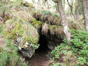
Lieu insolite: combien de cloisons mobile (ou bien: coincés maintenant)? Comptez tous.
Verlaten plaats: hoeveel beweegbare schotten ('t is te zeggen: nu vastgeroest)? Tel ze allemaal.
Lost place: how many movable (or rather crusted to a stop) partitions? Count them all.
A = ___
N49° 52. (A*3) 7 2 '
E4° 58. 2 (A-1) 1 '
Qu'est-ce qu'on trouve ici / wat vinden we hier / what do we find here?
- Une chapelle / een kapel / a chapel (B = 12)
- Une croix / een kruis / a cross (B = 7)
- Un momument aux Morts de la Guerre / een oorlogsmonument / a war memorial (B = 5)
B = ___
N49° 53. 4 (B+1) 1 '
E4° 57. B 2 9 '
1C6 habitants de Monceau et Petit-Fays se réfugièrent à cet endroit en 1914.
1C6 inwoners van Monceau en Petit-Fays schuilden hier in 1914.
1C6 inhabitants of Monceau and Petit-Fays took refuge here in 1914.
C = ___
N49° 54. 1 C 9 '
E4° 58. 1 C 6 '
Qu'est-ce qu'on trouve ici / Wat vinden we hier / What do we find here ?
- Rien de spécial / niks speciaals / nothing special (D = 1)
- Une chapelle / een kapel / a chapel (D = 2)
- Une croix / een kruis / a cross (D = 5)
D = ___
N49° 54. 9 D 4 '
E4° 58. (A-C) 8 1 '
Combien de bancs est-ce qu'on trouve ici?
Hoeveel banken vinden we hier?
How many benches do we find here?
E = ___
N49° 54. 4 (E-D) 9 '
E4° 56. (A+E) C 3 '
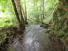
Ce pont est réalisé en / Deze brug is gemaakt van / This bridge is made of
- Béton / beton / concrete (F = 1)
- Bois / hout / wood (F=2)
- Métal / metaal / metal (F=5)
F = ___
Attention: si vous voulez éviter de devoir traverser le ruisseau sans pont plus loin, ne traversez pas ce pont mais continuez le même sentier.
Opgepast: als je wil vermijden om de stroom te moeten oversteken zonder brug, steek dan deze brug niet over en vervolg dezelfde weg.
Attention: if you want to avoid having to cross the stream without a bridge further on, do not cross the bridge but keep following the same path.
N49° 53. 3 (10-F) 9 '
E4° 55. 4 (2+F) 3 '
Demande de la construction de la ligne = 190G
Aanvraag voor de aanleg van de lijn = 190G
Request for the construction of the railroad = 190G
G = ___
Ici on peut faire la connection avec la série 'les Ponts de Nafraiture' pour ajouter 9 km à la randonnée. Les coordonnées de la multi GC5GJW3 peuvent être calculé en utilisant les codes déjà trouvées ici: N49° 54. E A (D-C) E 004° 54. (B-D) (G-E) (F+F)
Hier kan men de verbinding maken met de serie 'les Ponts de Nafraiture' om 9 km aan de wandeling toe te voegen. De coordinaten van de multi GC5GJW3 kunnen als volgt berekend worden met de codes hier gevonden: N49° 54. E A (D-C) E 004° 54. (B-D) (G-E) (F+F)
Here one can make the connection with the series 'les Ponts de Nafraiture' to add 9 km to the walk. The coordinates of the multi GC5GJW3 can be calculated using the codes already found here: N49° 54. E A (D-C) E 004° 54. (B-D) (G-E) (F+F)
N49° 52. (G+2) 2 8 '
E4° 55. 9 (G-2) 6 '
Altitude 3H0 / Hoogte 3H0
H = ___
N49° 52. (H*2) (H*2) 3 '
E4° 56. 6 7 0 '
Quel âge avait ce héros?
Hoe oud werd deze held?
How old was this hero when he died?
I = ___
SOS
SMS only between 9 et 21h
Parking : N 49° 52.ABC E 004° 56.DEF
SOS : 0497 1A FE 12
Checksums
A + B + C + D + E + F + G + H + I = 53
SEQUENCE:
F < C < A < H < D < E = G < B < I
Stash
PRENEZ LE TEMPS POUR LE CALCUL SVP
NEEM DE TIJD VOOR DE BEREKENING AUB
TAKE YOUR TIME FOR THE CALCULATION PLEASE
N 49° 52. (I - E - G) (A * C) (B - F) '
E 004° 56. (D + C) (E - H - C) (H + C) '
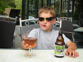 Time for a drink :-)