Vi har produceret denne earthcache i anledning af den Internationale EarthCache Dag søndag d. 11. oktober 2015.
We have produced this earth cache on the occasion of the International EarthCache Day Sunday October 11. 2015.
I Korsør-området findes et antal forskellige moræner, hvoraf flere ses i klinterne ved Korsør Skov. Morænerne repræsenterer sandsynligvis alle hovednedisninger i Weichsel Istiden og illustrerer desuden forskellig typer af moræneaflejringer.
Det er en vigtig lokalitet for studiet af glaciationsforløbet i Sydøstdanmark og storebæltsområdet. Klinterne indeholder desuden gode eksempler på forskellige morænetyper og aflejringsprocesser.
På kysten er bygget et stort antal høfder i forsøg på at beskytte kystlinien og klinterne mod vandets erosion.
Weichsel Istid - den sidste istid begyndte for ca. 117.000 år siden og sluttede for 11.700 år siden. I Tidlig Weichsel var Det Skandinaviske Isskjold ikke tilstrækkelig stort til, at gletsjere nåede Danmark. Fra Mellem Weichsel kendes derimod tre større gletsjerfremstød i Danmark, og fra Sen Weichsel, hvor isskjoldet voksede sig størst, fandt en kompleks nedisning sted, der dannede en suite af tre fremstød fra henholdsvis Norge, Sverige og Baltikum. Det var disse gletsjere, der formede størstedelen af vores nutidige østdanske istidslandskab. Mellem gletsjerfremstødene og udenfor deres rækkevidde herskede subarktiske forhold. Her fandtes tundra steppe og dværgbuskhede med rig flora og fauna. I de mildeste isfrie faser indvandrede en spredt krat- og buskvegetation af fyr og birk.
De forskellige moræneaflejringer ses i profil både i grusgrave og på klinter ved kyster. På klinterne må man forestille sig, at isen som en buldozer har skubbet lagene frem og anbragt dem, som man ser på klinten. I klinten ved Korsør Lystskov er lagene pænt vandret lagdelt, men mange andre steder ser man forskudte lag.
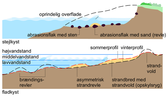
Nedbrydning: Danmarks kystklinter er udsatte for erosion. Her spiller mange faktorer en rolle: Afstanden til vandet, strømmens retning, bølgernes størrelse og frekvens, tidevandsforskelle i vandhøjden samt vejrforhold i form af blæst, regn og frost.
Stranden kan være forskellig i sommer- og vinterperioden. Sommerens rolige vejrforhold gør, at sandet får tid til at aflejre sig og omvendt kan sandet blive skyllet ud i havet ved større og hurtigere bølger om vinteren. Her vil stranden blive stenet. Strandene er også forskellige og afhængige af beliggenhed og strand-og havbundens beskaffenhed. Hvis eks. et strandområde ligger i læ for store bølger kan sandet forblive på stranden hele året.
Høfder har vist sig ikke at være særlig effektive, hvis man ikke løbende fylder sand i de eroderede områder. Derfor bygges der ikke længere høfder.
Kilder: Naturen i Danmark Geologien 2. udgave. Naturstyrelsen: Værdifulde geologisk områder. Region Sjælland.
For at logge denne cache skal du køre fra Skovvej ved Lystskov Camping ad Korsør Lystskovvej ca. 2 km. gennem skoven til parkeringspladsen. Herfra er der ca. 200 meter til stranden. Du skal besvare spørgsmålene og sende svarene til vores profil, derefter må du godt logge cachen.
Spørgsmål 1: På vej til Stage 1 ser du nogle steder tydelige tegn på nedbrydning af klinten. Hvilke tegn?
Stage 1:
Spørgsmål 2: Beskriv klinten, antal af lag, farverne og estimerede højder.
Spørgsmål 3: Beskriv stranden helt hen til kanten af klinten. Hvorfor ser den sådan ud?
Spørgsmål 4: Grav et hul på stranden. Mål hvor dybt hullet er, når du har nået et andet materiale.
Hvis du vil, så tag et billede af dig selv med klinten og en eller flere høfder (dog ikke klinten Stage 1)
In the area of Korsør are a number of different moraines, which can be seen in the cliffs of Korsør forest. The moraines probably represents all the Weichsel Ice Age and also illustrates the different types of moraine deposits.
It is an important site for the study of glaciations in Southeast Denmark and the Great Belt area. Cliffs also contains good examples of different types of moraines and deposition processes.
On the coast is built a great number of groynes for trying to protect the coastline and cliffs against water erosion.
Weichsel Ice Age - the last ice age started about 117.000 years ago and ended 11.700 years ago. In Early Weichsel was the Scandinavian ice sheet not large enough so that glaciers reached Denmark. From Middle Weichsel is known three major glacial campaigns in Denmark, and from the Late Weichsel where ice sheet grew most, found a complex glaciation place that formed a suite of three campaigns from Norway, Sweden and the Baltics. These were the glaciers that shaped the majority of our East Danish glacial landscape. Between glacier campaigns there was subarctic conditions. Here was tundra and dwarf shrub and heath with rich flora and fauna. In the mildest ice-free phases immigrated bushes and vegetation of pine and birch.
The different moraine deposits seen in profile both in the pits and on the cliffs of the coasts. On the cliffs, one must imagine that the ice as a buldozer has pushed the layers and placed them, as you look at the cliff. In the cliff at Korsor Lystskov the layers is nicely horizontally layered, but many other places one sees staggered layers.
Destruction: Denmark's coastal cliffs are exposed to erosion. Here, many factors play a role: The distance to the water, flow direction, wave size and frequency, tidal variation in water levels and weather conditions in the form of wind, rain and frost.
The beach can be different in summer and winter periods. Summers with calm weather conditions makes that the sand has time to settle out and, conversely, the sand being washed into the sea by the greater and more rapid waves in the winter. Here, the beach will be stoned. The beaches are different and depend on location and beach and bottom conditions. If for example a beach area is sheltered from large waves, the sand can stay on the beach all year.
Goynes have not proven to be particularly effective if you do not regularly come sand in the eroded areas. Therefore, there has not been build groynes the latest years
Sources: Nature in Denmark Geology 2nd edition. Nature Agency: Valuable geological areas. Region Zealand.
To log this cache you must drive from Skovvej by Lystskov Camping at Korsør Lystskovvej about 2 km. through the wood to the parking lot. From here there are about 200 meters to the beach. You must answer the questions and send the answers to our profile, then you may well log the cache.
Question 1: On your way to Stage1 you see some visible signs of destruction of the cliff. What signs?
Stage1:
Question 2: Describe the cliff, number of layers, colors and estimated heights.
Question 3: Describe the beach from the water to the edge of the cliff. Why do it like this?
Question 4: Dig a hole on the Beach. Measure how deep the hole is, once you have reached a different material.
If you want, take a picture of yourself with the cliff and one or more groynes (but not the Cliff stage1)