NOTE:
This is an EARTHCACHE!
There is NO PHYSICAL CONTAINER, and to log a find you need to email the answers to the questions below to me, by clicking on 'heartradio' just below the cache title and then clicking 'Send Email'.
If after 24 hours of you logging your find I still haven't received your answers, your log is at risk of being deleted.
BREAN DOWN
GEOLOGY
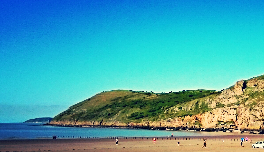
Brean Down is a promonotory off the coast of Somerset, England, standing 318 feet (97 m) high and extending 1.5 miles (2 km) into the Bristol Channel at the eastern end of Bridgwater Bay between Weston-super-Mare and Burnham-on-Sea.
Made of Carboniferous Limestone, it is a continuation of the Mendip Hills. Two further continuations are the small islands of Steep Holm and Flat Holm. The cliffs on the northern and southern flanks of Brean Down have large quantities of fossils laid down in the marine deposits about 320–350 million years ago. The site has been occupied by humans since the late Bronze Age and includes the remains of a Romano-Celtic Temple. At the seaward end is Brean Down Fort which was built in 1865 and then re-armed in the Second World War.
The Mendip Hills, of which Brean Down forms the mostly westerly part, are the most southerly Carboniferous Limestone upland in Britain. These rock strata were laid down during the early Carboniferous period, about 320–350 million years ago. Subsequently, much of northwestern Europe underwent continental collision throughout the late Paleozoic era, culminating in the final phases of the Variscan orogeny near the end of the Carboniferous period, 300 million years ago. This tectonic activity produced a complex suite of mountain and hill ranges across what is now southern Ireland, south-western England, Brittany, and elsewhere in western Europe. As a result of the Variscan mountain-building, the Mendip area now comprises at least four anticlinal fold structures, with an east-west trend, each with a core of older Devonian sandstone and Silurian volcanic rocks. West of the main Mendip plateau the Carboniferous Limestone continues in Bleadon Hill and Brean Down, and on the islands of Steep Holm and Flat Holm.
Brean Down is just over 2 kilometres (1.2 mi) long and runs in an east-west direction near the mouth of the River Axe opposite Uphill Cliff. The flat area on the top of the peninsula may represent a raised bench laid down when the sea level was much higher than it is today, as the highest point of the promontory is approximately 97 metres (318ft) above sea level. The cliffs on the north and south faces are rich in fossils that include corals, seashells and crinoids, which supports the theory of the marine deposition of the rocks. 13 separate layers have been identified in the 'sand cliff' on the south side, the lowest five dating to the millennia of the last glaciation.
BREAN DOWN INFORMATION
From GZ, you get a great view of your surroundings; including the Quantocks to your left, Steep Holm, Flat Holm and Wales (if you look closely at Cardiff you can see the Millennium Stadium!). Behind you is Brean Down Fort, the current buildings of which were constructed in the 1860s as one of the Palmerston Forts to provide protection to the ports of the Bristol Channel, and was decommissioned in 1901. During World War II it was rearmed and used for experimental weapons testing. The site has been owned by the National Trust since 2002, following a £431,000 renovation project as part of its Brean Down property and is open to the public. The small building in front of you was a searchlight position.
Access to the cache is best from the National Trust Car Park and from there use the two waypoints to get you to the top. There are steps and also a tarmac path. When on the top of Brean Down, walk along until you get to the fort. Follow your GPS down the other steps from the fort to GZ. Terrain is steep!
LOGGING TASKS
To claim a find on this Earthcache, you need to answer these questions at GZ and email the answers to me via my profile.
1) To your right (if facing Wales) there is a large fissure or cleft. Describe it and estimate its width.
2) How do you think this fissure would have been formed.
3) What is your altitude at GZ? You can estimate or use your GPS.
4) OPTIONAL TASK: Take a photograph of you/your GPS with the Searchlight Position building in the background.
You can log straight away (you don't need to wait for me to confirm answers). Please don't put answers in your log unless you particularly want it deleted.
Thanks to the National Trust for granting permission for this cache.
| I have earned GSA's highest level: |
 |