Rocca Busambra EarthCache
-
Difficulty:
-

-
Terrain:
-
Size:  (other)
Please note Use of geocaching.com services is subject to the terms and conditions
in our disclaimer.

 This cache is related to the Riserva Naturale Bosco della Ficuzza.
Thanks to Micascisto alias Stefano Nerozzi (University of Texas) that kindly provided for his part his expertise to realize this EC.
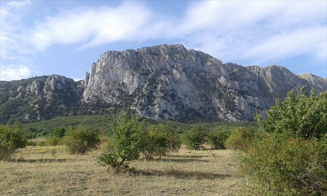
Introduction Rocca Busambra (1613 m), is the highest peak of the mountain range of the Sicani mountains and the highest peak in western Sicily. The summit is part of a prominent limestone outcrop, which dominates the surrounding territory of Corleone. The complex, structured along a ridge of 15 km consisting of several summits (from west to east: Pizzo Nicolosi, Rocca Argenteria, Rocca Ramusa, Pizzo Busambra, Pizzo Casa), looks like a ridge that rises on the green hills of the Ficuzza forest. The ridge is very uneven, especially on the northern side, with vertical walls and cliffs of impressive height. The southern slope, instead, has a smoother topography. Also notable is the prominence over the surrounding area, mostly hilly, a factor that contributes to the Rocca (“fortress”) the appearance of an isolated and majestic mountain.
Geologic framework The complex of Rocca Busambra consists mostly of limestone, classically divided into three main units: Mufara unit, Rocca Busambra unit and Numidian Flysch unit. All units, with ages ranging from the Triassic (~ 220 Ma) to the Miocene (~ 15 Ma), were raised, deformed and put in place during the Miocene orogeny that affected large areas of the western Sicily. The unit Mufara consists mainly of shale, marl and fine grain limestone. They are largely pelagic deposits, i.e. deposited in an offshore environment. This unit is the oldest in the area and dates to the Carnian (Triassic, about 220 Ma). In this case, the Rocca Busambra unit is the one of most interest since it makes up most of the mountain range. It consists entirely of carbonate rocks, from platform limestone to offshore calcarenite and marl. Within the platform limestone, outcropping in the lower portion of the chain, you can recognize many fossil, such as the remains of algae, brachiopods and bivalves (e.g., clams and mussels). As we move upwards these marine deposits gradually transition into marly limestone and glauconitic calcarenite, typical of deeper and offshore environments. The terms, though apparently arcane, describe a relatively simple geological context. A marly limestone, for example, is a very fine deposit of limestone, or calcium carbonate, with a small clay component. The term calcarenite, instead, indicates that the rock is a limestone made up in large part by sand-sized grains cemented by tiny carbonate crystals. Finally, the Numidian Flysch is a less relevant sequence of clays and silty clays (silt = a sediment slightly coarser than clay) with quartz lenses. It is the only non-carbonate unit in the area.
Hydrogeology The limestone that makes up Rocca Busambra is for the most part characterized by a low primary permeability but high secondary permeability. The primary permeability can be defined as the property of a native rock to let water run through its structure, ie in the absence of fractures and/or secondary paths. In the specific case of Rocca Busambra, we can even identify large porosities, but the individual pores are generally poorly interconnected, preventing significant water flow. The rocks themselves, however, are intensely fractured and locally present karst features that greatly increase the secondary permeability. The significant areal development of the territory and its high permeability due to fractures makes Rocca Busambra an important hydrogeological complex. In fact, it can be considered one of the major rainwater recharge areas and one of the main surface and subsurface water flow complex. Groundwater often arise to the surface creating springs, such as the Malvello and Drago springs.
Earthcache The main purpose of an Earthcache is to present and explain one or more Earth science topics. At Rocca Busambra, we can observe various aspects of carbonates geology:
- A sequence of limestone, marl and clay formed in environments ranging from platform to the open sea
- The mechanical strength of limestone compared to that of shale and clay
- The relationships between rock type and fracturing and hydrological flows.
In order to log this cache you must complete the following exercises, sending answers and explanations to geocachingsicilia@gmail.com. The description contains some information, other details will come from your own observations of the landscape and rock outcrops. You may log the cache after emailing the answers; corrections or questions will follow if necessary.
0) Report the number of participants in the search for this Earthcache.
1) Using the GPS or a topographic map, report the elevation at the Earthcache waypoint.
2) What is the main type of rock that forms Rocca Busambra? Describe rock indicating the color, its appearance (smooth, granular, pebbly, etc.), the presence of fractures and fossil (if visible). If you are not hiking up to the summit, you can base your observations on the rock outcrops at the base.
3) Is there only one type of rock, or more than one? If more than one, briefly describe (1 line) every rock you recognize using the criteria described in section 2.
4) Look at Rocca Busambra as a whole. What type of rock do you see outcropping, perhaps with only minor vegetation cover? What rock type makes up the highest peaks and steepest slopes? What do you deduce in terms of mechanical strength of these rocks, compared to those that make up the nearby valleys and hills?
5) Look at the landscape. Do you see any rivers flowing down the mountain range? Based also on the information provided in the description, do you believe that the water flows mostly on the surface or underground?
6) During your stay in this area, did you notice any building or other structures in which the limestone of Rocca Busambra was used? If yes, do you believe that this rock has been an important resource for the past and recent populations of this territory?
 Questa cache è riferita alla Riserva Naturale Bosco della Ficuzza.
Grazie a Micascisto alias Stefano Nerozzi (University of Texas) che ha gentilmente e a livello personale messo a disposizione le sue conoscenze per la realizzazione di questa EC.
Introduzione Rocca Busambra (1613 m), è il rilievo più alto del gruppo montuoso dei monti Sicani, nonché la cima più alta della Sicilia occidentale. Il rilievo fa parte di un prominente affioramento calcareo che sovrasta il circostante territorio di Corleone. Il complesso, articolato lungo una dorsale di 15 km costituita da più rilievi (da ovest a est: Pizzo Nicolosi, Rocca Argenteria, Rocca Ramusa, Pizzo Busambra, Pizzo Casa), si presenta come una cresta che si erge sulle verdi colline del bosco della Ficuzza. Il rilievo appare molto frastagliato, soprattutto sul versante settentrionale, con pareti verticali, e tratti strapiombanti di impressionante altezza. Il versante meridionale digrada invece più dolcemente. Notevole è anche la prominenza sul territorio circostante, in gran parte collinare, fattore che contribuisce a dare alla rocca l’aspetto di un rilievo isolato e maestoso.
Contesto geologico Il complesso di Rocca Busambra consiste per la maggior parte di rocce calcaree, classicamente suddivise in 3 unità principali: l’unità Mufara, l’unità Rocca Busambra e l’unità del Flysch Numidico. Tutte le unità, aventi età comprese tra il Triassico (~220 Ma) e il Miocene (~15 Ma), sono state sollevate, deformate e messe in posto durante l’orogenesi Miocenica che ha interessato molte aree della Sicilia occidentale. L’unità Mufara è composta principalmente da rocce argillose, marnose e calcaree fini. Si tratta in gran parte di depositi pelagici, cioè di mare aperto. Questa unità è la più antica della zona e risale al Carnico (Triassico, circa 220 Ma). L’unità Rocca Busambra è, in questo caso, quella di maggior interesse in quanto compone interamente la catena montuosa. Si tratta interamente di rocce calcaree, dai calcari di piattaforma a calcareniti e marne di mare più aperto. Tra i calcari di piattaforma, affioranti nella parte più bassa della catena, si possono riconoscere numerosi resti fossili, quali resti di alghe, brachiopodi e lamellibranchi (i bivalvi, come vongole e cozze, sono un esempio). Salendo verso l’alto si trovano invece depositi di mare tendenzialmente più aperto e profondo, come calcari marnosi e calcareniti glauconitiche. I termini, seppur apparentemente arcani, descrivono un contesto geologico relativamente semplice. Un calcare marnoso, per esempio, è un deposito molto fine di calcare, o carbonato di calcio, con una piccola componente argillosa. Il termine calcarenite, invece, indica che la roccia è un calcare formato per la maggior parte da grani di dimensione di una arenaria, ovvero sabbia cementata (in questo caso da piccoli cristalli di calcare). Infine, il Flysch Numidico è una successione meno rilevante di argille e argille siltose (silt = un sedimento poco più grossolano delle argille) con lenti di quarzo. Si tratta dell’unica unità della zona a carattere non carbonatico.
Idrogeologia Le rocce calcaree che compongono Rocca Busambra sono per la maggior parte caratterizzate da una scarsa permeabilità primaria ma elevata permeabilità secondaria. La permeabilità primaria può essere definita come la capacità di una roccia nativa a lasciarsi attraversare da acqua, cioè in assenza di fratture e/o passaggi secondarie. Nel caso di Rocca Busambra troviamo alcuni calcari con porosità anche rilevanti, ma i singoli pori sono generalmente poco interconnessi, impedendo flussi idrici significativi. Le stesse rocce, però, sono intensamente fratturate e presentano localmente episodi di dissoluzione carsica che incrementano notevolmente la permeabilità secondaria. Il notevole sviluppo areale del territorio e la sua elevata permeabilità per fratturazione fanno di Rocca Busambra un importante complesso idrogeologico. Infatti, esso può essere considerato una delle maggiori superfici di assorbimento delle acque piovane e una delle principali vie di scorrimento delle acque superficiali e sotterranee. Le falde sotterranee scaturiscono spesso in sorgenti, quali la sorgente Malvello e la sorgente Drago.
Earthcache Lo scopo principale degli Earthcache è quello di mostrare e spiegare uno o più temi delle scienze della Terra. A Rocca Busambra possiamo osservare vari aspetti della geologia relativa alle rocce carbonatiche:
- Una successione dal basso verso l’alto di calcari, marne e argille da ambienti di piattaforma a mare aperto
- La competenza (resistenza meccanica) delle rocce calcaree rispetto a quelle argillose
- Il rapporto tra tipologia e fratturazione di una roccia e i flussi idrogeologici.
Per poter loggare questo cache è necessario svolgere i seguenti esercizi, inviando risposte ed eventuali spiegazioni a geocachingsicilia@gmail.com. Alcuni dati sono presenti nella descrizione, altri si ottengono osservando il paesaggio e le rocce affioranti. Una volta inviate le risposte è possibile loggare il cache; eventuali correzioni o ulteriori domande seguiranno se necessario.
0) Indica il numero di partecipanti nella ricerca di questo Earthcache.
1) Utilizzando il GPS o una carta topografica, riporta l'altitudine al punto dell’Earthcache.
2) Qual è il principale tipo di roccia che forma Rocca Busambra? Descrivi la roccia indicando il colore, il suo aspetto (liscia, granulare, formata da ciottoli, ecc.), la presenza di fratture e fossili (se visibili). Se decidi di non risalire fino alla cima, puoi basare le tue osservazioni sugli affioramenti rocciosi alla base.
3) C’è un solo tipo di roccia o più di uno? Se più di uno, descrivi brevemente (1 riga) ogni roccia che riconosci secondo i criteri indicati al punto 2.
4) Osserva la Rocca nel suo complesso. Quali rocce vedi affiorare, magari poco coperte da vegetazione? Quali costituiscono le cime più elevate e i pendii più scoscesi? Cosa ne deduci in termini di competenza (resistenza meccanica) di queste rocce rispetto a quelle che costituiscono le valli e colline circostanti?
5) Osserva il paesaggio. Noti corsi d’acqua che scendono dalla Rocca? Basandoti anche sulle informazioni fornite nella descrizione, ritieni che le acque scorrano per la maggior parte in superficie o nel sottosuolo?
6) Durante la tua permanenza in questa zona, hai notato edifici o altre costruzioni in cui è stato fatto uso delle rocce calcaree di Rocca Busambra? Se sì, ritieni che questa roccia sia stata una risorsa importante per le popolazioni recenti e passate di questo territorio?
Project issued by/Progetto promosso da:


Additional Hints
(No hints available.)