REALLY SideTracked - Birkenhead Railway Branch Line. This is commonly known to you and I as the ‘Wirral Way’. The Wirral Way was a branch line of the Birkenhead Railway, which was formed on 1st August 1859. The branch line from Hooton to Parkgate was opened on 1st October 1866, and this line was extended to West Kirby on 19th April 1886. The line closed to passengers in 1956, and to freight in 1962, but it was revamped as a country park, which opened in 1973. This is what you are walking on today.

This EarthCache takes you to a section between Lees Lane in Little Neston, to Mellock Lane in Neston, not too far away from the former station, Neston South. In order for the railway to pass through, the sandstone had to be cut through by hand and as you walk, cycle or ride through this section, please take a moment to think of the hard work and effort that was put into excavating this rock for the railway.
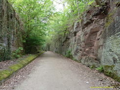
The Neston rock cuttings are formed of sandstone, a sedimentary rock that is formed when layers of sediment are crushed over a period of millions of years. Small pieces of rock are deposited by water in the ice age and pressure forces these bits of sediment together; this process is called sedimentation. In North West Cheshire, the rocks are heavily faulted and the underlying Carboniferous Coal Measures are thrown up (Coal Measures being the term used for the coal-bearing part of the Upper Carboniferous System). Coal Measures strata occurs in the Neston area, but this is hidden by glacial till and estuarine alluvium.

To log a find on this EarthCache, I would like you to visit the waypoints listed below and answer the questions at the appropriate points.
1) Measure the exact length of the rock face, from START (WP1) to END (WP6)
2) At WP2, describe the pattern of the rock near to No.5 and guess as to how these patterns might have occurred
3) At WP3, you will see lots of long elongated marks in the rock, these are from when the workers were digging out the rock for the railway, using their pickaxes. Estimate the length of any one of these marks.
4) At WP4, you are at the tallest part of the rock face. Estimate the height of the rock face at this point.
5) At WP5, the appearance of the rock face differs slightly to the rest of the rock face. Describe what differences you see at this point, including the different colours and textures of the rock.
6) Optionally, take a photo of yourself at the listed co-ordinates
Please do not post the answers in your log, instead email me via my profile.
This cache has been allowed with the kind permission of the Cheshire West and Chester Greenspace team, so please respect the location that you are visiting and remember, it has lasted all these millions of years, so please help it last for millions more.