SLO: Ime vasi je najverjetneje izpeljanka iz besede "laze", ki pomeni otrebljen svet - okoli vasi se namreč res nahajajo predvsem njive, pašniki in redek gozd. Sicer pa je Lazec strnjena hribovska vas nad desnim bregom Idrijce pod Pluženjsko goro na 550 metrih nadmorske višine. Na severozahodni strani (cca 1km od središča vasi) je grapa, po kateri teče potok Lupnica, ki se v Pirhovi luknji izliva v Idrijco. Od njem je bil vodni mlin, ki ga je leta 1984 skupaj z mlinarjevo hišo odnesel zemeljski plaz. Prva omemba imena vasi sega v leto 1290, v Tolminskih urbarjih iz leta 1377 pa je zapisano, da je bilo v Lazcu že šest kmetij, katerih lastniki so morali oddajati oblasti svoje dajatve v žitu, mesu, siru, medu in denarju. Ocenjuje se, da je Lazec okoli tisoč let stara vas, toliko kot ostala naselja na desni strani Idrijce, saj so se prvotni prebivalci naseljevali na bolj sončnih legah.
Vir: Spletna stran DLGSM - www.lazec.si
ENG: The name of the village Lazec most likely originates from the word "laze", which means stripped grounds - around the village are mostly fields, pastures and easily transient woods. Lazec is a compact village above the right bank of river Idrijca and under the hill Pluženjska gora at 550 meters above sea level. On the northwest side of the village (cca 1km from the village center) there is a ravine with creek Lupnica, which flows into the river Idrijca. There used to be a water-mill on this creek, but has unfortunately been destroyed together with a miller's house in a big landslide in 1984. First mention of the village dates back to the year 1290 and in Tolmin terriers from 1377 it is stated, that Lazec has six farms, whose owners had to pay taxes to the authorities in cereals, meat, cheese, honey and money. It is estimated that Lazec is about a thousand years old, similar as other settlements on the right bank of the river Idrijca, as the original inhabitants settled on the sunniest slopes.
Source: Website of DLGSM - www.lazec.si
- - - - - - - - - - - - - - - - - - - - - - - - - - - - - - - - - - - - - - - - - - - - - - - - - - - - - - -
SLO: Z na novo zgrajenega vaškega središča (upravitelj središča je Društvo ljudskih godcev Stari meh Lazec), ki je takorekoč edina ravna površina sredi klancev, se ponuja čudovit razgled na vaško cerkev sv. Jurija in na del doline reke Idrijce med sosednjimi hribi.
Zakladek leži na zasebnem zemljišču, vendar se lastniki zemljišča in objekta s tem v celoti strinjajo - mogoče jih boste med iskanjem celo srečali :). S seboj prinesite pisalo!
ENG: From the newly built village sports field (administrator of the place is a local Association of folk musicians "Old bellows" Lazec) , which is basically the only flat surface in these hills, you can enjoy the beautifull view of the St. George church and of one part of Idrijca valley between the surrounding hills.
The cache is placed on a private property, but the owners of the property and building fully agree with it - you may even meet them on spot :). Bring your own pen!
- - - - - - - - - - - - - - - - - - - - - - - - - - - - - - - - - - - - - - - - - - - - - - - - - - - - - - -
SLO: Dostop s primorske strani: Z glavne ceste G2-102 (Idrija-Tolmin) zavijete na lokalno cesto pri odcepu za Otalež ter se povzpnete do vasi Plužnje (2,4km). Sredi Pluženj sledite tabli za Lazec (zavijete ostro levo v bližini gasilskega doma) in se zapeljete do vrha vasi (0,8km), kjer lahko parkirate na majhnem neoznačenem parkirišču poleg vaškega središča - športnega igrišča.
Dostop z gorenjske strani: Z regionalne ceste R1-210 (Škofja Loka-Cerkno) zavijete levo na lokalno cesto v kraju Sovodenj in sledite tablam najprej za Jazne in nato za Otalež (5,8km). Iz Otaleža nadaljujete proti Plužnjam (1,7km) in sredi vasi Plužnje zavijete desno navzgor in se zapeljete do vrha Lazca (0,8km), kjer lahko parkirate na majhnem neoznačenem parkirišču poleg vaškega središča - športnega igrišča.
ENG: Directions from Primorska side: From main road G2-102 (Idrija-Tolmin) make an exit at the sign "Otalež" and climb to the village Plužnje (2,4km). In the middle of Plužnje follow the sign "Lazec" (sharp left turn in the vicinity of fire-station) and climb to the top of the village (0,8km), where you can park on a small non-marked parking place next to sports field.
Directions from Gorenjska side: From regional road R1-210 (Škofja Loka-Cerkno) make a left exit in the middle of village Sovodenj and follow the signs for Jazne first and Otalež later (5,8km). From Otalež continue to Plužnje (1,7km) and in the middle of Plužnje turn right and climb to the top of Lazec (0,8km), where you can park on a small non-marked parking place next to sports field.
- - - - - - - - - - - - - - - - - - - - - - - - - - - - - - - - - - - - - - - - - - - - - - - - - - - - - - -
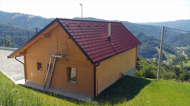 Vaško središče / Village sports field - Vir/Source: Spletna stran DLGSM / Website DLGSM
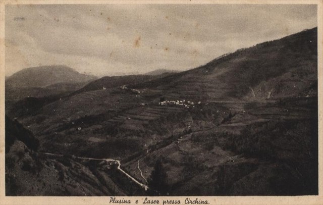 Lazec nekoč / Lazec in the past - Vir/Source: Spletna stran DLGSM / Website DLGSM
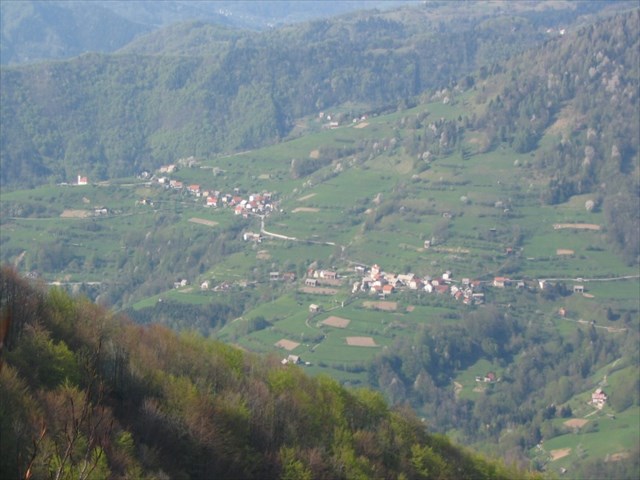 Lazec danes / Lazec today - Vir/Source: Spletna stran DLGSM / Website DLGSM