Please note - there is NO guaranteed cell phone reception at this cache site. Know the requirements for this earthcache before arriving.
Important things to know to avoid log deletion:
- if your answers will be sent at a later time, state when I will receive them in your found log.
- required photo must be personalized in some way so that I know you were truly there.
If I delete your found log due to lack of following instructions, you can re-log your find when you are able to comply.
Mount Rainier National Park is open all year. There is an entrance fee, good for 7 days, for each vehicle entering the park unless you have a special pass such as an annual pass or a Golden Eagle Pass. Information about these passes can be obtained at the entry points to the park. Please park only in designated parking spots and do not leave the trails/sidewalks during your explorations.
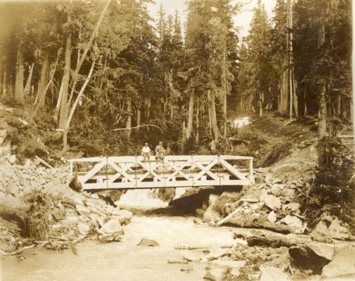
Kautz Before 1947 Lahar
VALLEYS SHAPED BY FIRE AND ICE
The stillness of the view is deceptive – this is a powerful, dynamic mountain. During the past 500,000 years lava from thousands of eruptions flowed and cooled, building the present volcano. Those lava flows are visible as gray and reddish rocks.
Glaciers far larger than today enveloped Mount Rainier during those eruptions.
Mount Rainier has repeatedly undergone sudden and drastic change. As eruptions of lava and ash built the cone, other geologic forces acted to destroy it – landslides, glaciers, rivers, and LAHARS (volcanic mudflows.) Similar activity is certain to occur in the future and is likely to dramatically affect the people and land of the Pacific Northwest.
WHAT IS A LAHAR?
Lahar is an Indonesian term that describes a hot or cold mixture of water and rock fragments flowing down the slopes of a volcano and/or river valleys. When moving, a lahar looks like a mass of wet concrete that carries rock debris ranging in size from clay to boulders more than 10 m in diameter. Lahars vary in size and speed. Small lahars, less than a few meters wide and several centimeters deep, may flow a few meters per second. Large lahars, hundreds of meters wide and tens of meters deep, can flow several tens of meters per second--much too fast for people to outrun.
As a lahar rushes downstream from a volcano, its size, speed, and the amount of water and rock debris it carries constantly changes. The beginning surge of water and rock debris often erodes rocks and vegetation from the side of a volcano and along the river valley it enters. This initial flow can also incorporate water from melting snow and ice (if present) and the river it overruns. By eroding rock debris and incorporating additional water, lahars can easily grow to more than 10 times their initial size. As a lahar moves farther away from a volcano, it will eventually begin to lose its heavy load of sediment and decrease in size.
WHAT TRIGGERS A LAHAR?
Eruptions may trigger one or more lahars directly by quickly melting snow and ice on a volcano or ejecting water from a crater lake. More often, lahars are formed by intense rainfall during or after an eruption--rainwater can easily erode loose volcanic rock and soil on hillsides and in river valleys. Some of the largest lahars begin as landslides of saturated and hydrothermally altered rock on the flank of a volcano or adjacent hill slopes. Landslides are triggered by eruptions, earthquakes, precipitation, or the unceasing pull of gravity on the volcano.
EFFECTS OF LAHARS
Lahars racing down river valleys and spreading across flood plains tens of kilometers downstream from a volcano often cause serious economic and environmental damage. The direct impact of a lahar's turbulent flow front or from the boulders and logs carried by the lahar can easily crush, abrade, or shear off at ground level just about anything in the path of a lahar. Even if not crushed or carried away by the force of a lahar, buildings and valuable land may become partially or completely buried by one or more cement-like layers of rock debris. By destroying bridges and key roads, lahars can also trap people in areas vulnerable to other hazardous volcanic activity, especially if the lahars leave deposits that are too deep, too soft, or too hot to cross.
After a volcanic eruption, the erosion of new loose volcanic deposits in the headwaters of rivers can lead to severe flooding and extremely high rates of sedimentation in areas far downstream from a volcano. Over a period of weeks to years, post-eruption lahars and high-sediment discharges triggered by intense rainfall frequently deposit rock debris that can bury entire towns and valuable agricultural land. Such lahar deposits may also block tributary stream valleys. As the area behind the blockage fills with water, areas upstream become inundated. If the lake is large enough and it eventually overtops or breaks through the lahar blockage, a sudden outburst flood (or lahar) may bury even more communities and valuable property downstream from the tributary.
CURRENT LAHAR ACTIVITY ON MOUNT RAINIER
The type of lahar activity seen most recently on the mountain has been outburst floods. Geologists sometimes call outburst floods jökulhlaups, the term for the phenomenon in Iceland, where some of the world's most spectacular outburst floods have occurred.
An outburst flood from the Kautz Glacier (site of this earthcache) in 1947 triggered a debris flow that traveled more than 5 miles downstream, burying the Nisqually-Longmire Road under 28 feet of mud and debris.
There have been outburst floods in this area as recently as the 1980s.
Outburst floods occur without warning, and there's growing concern at Mount Rainier that water suddenly released from the Nisqually Glacier could race like a tidal wave through the historic settlement of Longmire which is heavily populated by park visitors in summer months.
Large glacial outburst floods often morph into debris flows (lahars) which are liquefied masses of water, rock and mud that travel rapidly downhill, destroying or burying everything in their paths.
Evidences you may observe of these outbursts are scouring of rocks, mud and debris deposits, and ghost forests. Ghost forests are trees killed by rising water levels, changing river courses, roots suffocated by mud deposits, or, in this area, trees that were stripped, buried, and then re-exposed by erosion.
Sources of information: Mount Rainier staff and various usgs.gov and nps.gov publications
To log this earthcache, please do things as follows:
1. Visit both the given coordinates and the waypoint coordinates. Observe the valley from both vantage points to see all evidences of the 1947 lahar. Refer to the written materials on this cache page to help with you answers.
Note: There is no need to leave the trail, and doing so is not recommended due to loose and unstable terrain. Use caution and watch for traffic in the roadway.
Note: if you are wheelchair bound, you will be able to claim this find by only visiting the waypoint location.
2. Send your answers to the questions in #4 directly to me and try to log your find at the same time so that I don't lose track of who sent answers. If answers will be delayed, note that in your found log.
3. If possible, send your answers the message center, either by going to the top of the cache page and selecting "Message this owner" or by going to my profile and selecting "Send Message" I will then be able to respond directly and easily. If you select "Send Email," I will still respond via the message center. During peak visiting times, this may take a few days.
4. Questions and answers - Critical - because I don't have the questions to my many earthcaches memorized - copy and paste the following into your message and add your answers: (include "a" so I know which earthcache you have done.)
- a) The name of the cache: The Ghosts of Lahars
- b) If the 1947 outburst flood covered the bridge with 28 feet of mud and debris, estimate the depth of the snout of the flow. (Answer is not on the signs.)
- c) How many ghost trees can you see from the stated coordinates?
- d) List two other pieces of evidence still visible from the 1947 lahar at the stated coordinates.
- e) The small stream that flows through this channel today is not Kautz Creek. Kautz Creek changed its channel in 2006 due to a flood. Where is the new Kautz Creek channel?
5. A photo of you is required on your "found" log to keep your find in place. If camera shy use a name badge of some sort to show you were there.