Being a geologist is a bit like being able to read time. Everything that happens on our Earth writes its influence on the landscape, and like any good story, as the pages turn, each plot point builds on the developments before. If you know what to look for, you can inspect a rock or a landscape and "read" what brought it to be, and in what order. You can piece together the story of how the world came to look the way it does, and even make a guess about what might be coming up in the next chapter.
Of course, in reality, reading the geologic story is much more difficult than this. The pages are torn and scattered, and some of them have gone missing or been smudged beyond recognition. The language is difficult to interpret.
Even so, with patience, geologists can put together the story behind the scenery, the story of how the world was built and torn down and built up again. So it is with the landscape around you.
PARKING
This location is accessible only during the summer. Winter buries Chinook Pass under 15 feet of snow, and in the spring, Washington State Department of Transportation plows slowly push and blow it away from the roadway. The pass is usually open by Memorial Day, and often earlier depending on how severe the winter was. It'll remain open until the first solid winter storm, usually in November. You'll find good information on conditions at Chinook Pass on the WSDOT website. If the road is closed, bookmark this Earth Cache and plan to revisit it next spring.
Park in the Tipsoo Lake parking lot. Bathrooms are available, and when you finish the Earth Cache, stay and hike the short loop trail around Tipsoo Lake. On a clear day, the views are spectacular! Please stay on the trails: with only a few months in which to grow between spring melt and autumn snow, the subalpine plants here are exremely sensitive to being trampled. If you'd like a longer hike, head half a mile east to the parking lot just outside the National Park, and take the three-mile Naches Peak loop.
WAYPOINT 1
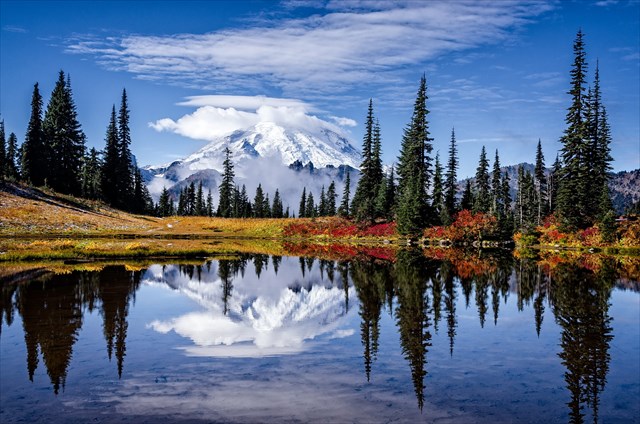
To get to the first waypoint, walk carefully along the roadway on the broad shoulder to the marked coordinates. You do not have to cross the road, but if you do, watch carefuly for traffic. Look around you. From this spot, you can see 40 million years of geologic history, including three of the four most recent chapters in the story of our landscape.
- Behind you is a rock cliff. The volcanic material that makes up this cliff extends deep into the earth beneath your feet -- in some places it is as much as two miles thick. First described by geologists a short distance south of this location, it is called the "Ohanapecosh Formation." This thick layer of lava and other volcanic material is the accumulation of thousands of volcanic eruptions that piled up over time.
- In the distance in front of you, you will see a series of rock spires projecting into the sky. These are the "Cowlitz Chimneys." They represent the hard inner cores of a chain of volcanoes. The outer shells of these volcanoes have eroded away, leaving behind only the material that hardened within the central chambers of the volcanoes themselves, called "plutons." The Chimneys rise through and over top of the Ohanapecosh layer.
- Behind the chimneys stands Mount Rainier, rising nearly twice as high above sea level as the Cowlitz Chimneys: 14,411 feet in elevation, the tallest volcano in the Cascade Range today. Lava ridges radiate out from a double crater atop the volcano, the valleys between them filled with massive glaciers. The whole edifice stands on top of the Ohanapecosh Formation, and pumice and ash from its most recent eruptions can be found on the surface throughout the visible landscape.
- Under the cone of Mount Rainier, and exposed in places around the edges (though not visible here), are the remnants of another volcano that once existed in roughly the same spot. These traces are almost completely eroded away, a nearly-missing chapter in the landscape, tucked beween the Ohanapecosh and Cowlitz layers and the lava flows of the current volcano.
WAYPOINT 2
Walk back up the road to waypoint 2. Look for a low tree overhanging an interesting set of boulders at the base of the cliff. Within the boulders you will see intriguing colors and patterns. The color comes from chemicals in the rock, and the patterns translate (in geologic language) into the story of how the rock formed. This is called "welded tuff," and rather than being formed by flowing lava, it was the result of pumice and other rocky debris thrown out of a volcanic vent that later welded itself together under its own weight and intense heat.
QUESTIONS
To claim credit for this Earth Cache, please send answers to the following questions to the cache owner by clicking on my name at the top of the page. If possible, use the "Message Center" option, as it's easier for me to keep track of who I've responded to. I will send you the code word associated with this cache for the GeoTour.
- Based on the text above and your observations of the scenery at Waypoint 1, in what order do you think each element of the landscape occurred? Match up each geologic feature with its age (see the attached diagram of rock layers for clarity):
Features
Cowlitz Chimneys
Mount Rainier
Ohanapecosh Formation
Remnants of a previous volcano
Ages
30-40 million years ago
30 million years ago
1 million years ago
500,000 years ago
- Describe the welded tuff at Waypoint 2. What color is it? What size are the objects embedded in it? Describe their texture.
- Do you think the cliff layer at Waypoint 2 erupted under water or in air? Why do you think so?
- Photos are not required but are always enjoyed. If you have time, post a photo of the view on the day you were here. Do not post photos of the welded tuff! -- such photos will be deleted.

2016 was the 100th anniversary of the National Park Service, and to celebrate, Visit Rainier and the Washington State Geocaching Association (WSGA) hosted the Visit Rainier Centennial GeoTour - 100 caches placed in and around Mount Rainier National Park. The geocaches highlighted the rich history, scenic wonders, quaint communities, and hidden gems of the Rainier region. The caches were released in four series of 25 caches each during 2015 and 2016.