Myriad Faces of Corkscrew Swamp Sanctuary
Lovingly placed by the Tropical Heritage Team
Welcome to one of the most beautiful places in Southwest Florida, Corkscrew Swamp Sanctuary. On this adventure, you will be presented with over four types of Florida ecosystems, and will be given the opportunity to observe and understand them more fully. Corkscrew Swamp Sanctuary is a non-profit Audubon facility, and they rely on admission prices to fund the facility. Admission (2-day pass) for adults is $14, college students are $6, children between 6 and 18 are $4, and under 6 are free.
This EarthCache will be entirely along an even boardwalk, which is wheelchair accessible. You will walk approximately 2.25 miles, so plan on devoting at least 2 hours for this cache. The park opens at 7:00 am daily, final admission is sold at 4:30 pm and you must be off the trail by 5:30 pm. To complete this Earthcache, please remain on the Main Trail, except for a short jaunt to the Marsh Observation Deck.
I suggest that you wear long sleeves and pants, and use bugspray with D.E.E.T. to deter biting flies and mosquitos, especially during rainy season. I also suggest you bring a camera as well as a pair of binoculars to observe and remember your experience at the Swamp.
Don’t Forget - Grab your Kit!
When you enter the welcome center and pay your admission, please let the attendant know that you are participating in this EarthCache. Each group will be lent a water depth measuring kit. You will need this kit to answer some of the questions presented in the EarthCache. Instructions are included in the kit. Please remember to clean the kit after use so that others can enjoy the same experience. I have posted instructions in the photos if you are interested in making your own kit, as well as how to use it.
Science and the Power of Observation
Science begins with the senses. What do you hear? See? Smell? Touch? These are all questions scientists ask themselves when something appears unique and stimulating. Even in our seemingly advanced society, there are many questions that either have not been asked or do not have answers yet. Science is dynamic and wonderful, yet it starts with and sometimes relies on the most basic aspects of being. This EarthCache will ask you to open your mind and focus on your senses as you observe the world around you. Try to focus on each individual sense – as applicable – to begin formulating your thoughts. Gain as full of an understanding of your surroundings as possible before you assemble your conclusions.
Hydrology: The Rainfall-Runoff Relationship
Unlike much of the United States, Southwest Florida has only two seasons. The dry season extends from early fall to mid-spring and features variable temperatures and extended periods of dryness. The other portion of the year is considered the wet or rainy season, in which frequent storms dump heavy but brief rainfall over the area.
Whether you visit this EarthCache in the rainy or dry season, you will find evidence of the frequent precipitation that occurs during the spring and summer months. While precipitation falls throughout the area of the Sanctuary in a relatively equal distribution, you will come across defined ecosystems that have different amounts of surface water. The depth of surface water in an area and its hydroperiod, or the duration of the year that there is surface water, is important in determining and shaping the ecosystem.
After water falls as precipitation, there are many paths that it can travel. A portion of water re-enters the atmosphere as water vapor, either by evaporation or transpiration (i.e. water taken up by plants and “respired” as water vapor), in a process called evapotranspiration. However, much of the water remains on and is absorbed by the ground.
After rainwater is absorbed by the ground, it first enters the zone of aeration. The zone of aeration is comprised of loosely packed sediment that allows for the storage and flow of water. A soil layer is at the top of this zone, which nurtures many plants and animals. Between grains of soil, air intermixes with water in the zone of aeration.
Water entering the soil area of zone of aeration will move laterally or downward unless it is absorbed by tree roots. Just like a body with mass, water is also influenced by the force of gravity, and will have a tendency to flow downward unless acted upon by another force or barrier. Water will eventually infiltrate through the zone of aeration and become part of the water table in the zone of saturation. The zone of saturation has very little air between grains and is mostly or completely filled, or saturated, with water.
The water level in the ground rises and falls throughout the year. In many Florida ecosystems, the water level will extend into the zone of aeration and reach the surface in mid to late summer. When the water level reaches ground level, any additional influx of water will cause flooding, or surface water. Surface water defines the hydroperiod, which, as you will see today, is part of a feedback loop that shapes the ecosystem.
While participating in this EarthCache, you might notice that certain areas seem to have more surface water than other areas. Surface water is an indication that water is entering an area faster than it flows out of the area. Besides precipitation, an area will receive water primarily from other areas that are at higher elevations. A general rule is that water will flow from areas of higher elevation to areas of lower elevation unless acted upon by an impermeable barrier, such as a layer of rock.
Ground water flows much like surface water. Water in the zones of aeration and saturation will also travel laterally to lower elevations (see image below). For the zone of aeration, this process is called interflow, and for the zone of saturation, this process is called baseflow. Surface water will also travel from higher to lower elevations in a process called overland flow, or runoff. These three processes contribute to make lower areas wetter for longer than higher areas in most instances.

Image source: http://www.co.portage.wi.us/groundwater/undrstnd/runoff.htm
The amount of surface water and, subsequently, the hydroperiod are also influenced by soil composition. Florida soils are primarily comprised of rock/sand or organic matter of various grain sizes and shapes. These qualities determine how the soil grains sort, which in turn determines the amount of empty spaces and size of these spaces between the soil grains. The spaces between grains allow for the infiltration of groundwater into the water table.
Porosity is the measure of the amount of empty space in soil. When the soil is dry, this empty space is filled in with air. When the soil is wet, this space is filled in by a mixture of air and water. The amount of air to water varies, and is dependent upon how wet the area is.
Porous soils are those that have lots of empty space, such as gravel or sand. These allow for more infiltration of water than a less porous soil, such as solid bedrock. However, porosity does not always predict the rate at which water infiltrates. Pumice, an igneous rock that is commonly used as a scrubber stone in showers is very porous (has many air pockets). You would not be able to run water through it, though, because its pores are not connected. South Florida generally has very porous soils that also allow for rapid infiltration.
The rate of infiltration is highly dependent upon another quality of soil, its permeability. Permeability is a property of the soil relating to its ability to allow water to pass through it. More permeable soils allow for a faster rate of water flow. To better understand the permeability of soil, it is important to consider the size and configuration of the individual pores between soil grains. Soils with pores that are of smaller diameter have a tendency to retard water flow. This is because the water would rather adhere to the soil grains and cohere with itself than flow with gravity. Conversely, soils with larger pore diameters between grains will exhibit a faster flow rate. You can visualize this by passing water through filters of various pore sizes. Filters with small pores pass water less quickly than filters with bigger pores. Soils with larger pore diameters are generally comprised of larger, uniformly-sized soil grains, and soils with smaller pore diameters are comprised of smaller or mixed soil grains. Soils with larger grains, such as pure gravel, are more permeable than soils with smaller grains, such as sand or, even smaller, silt or peat.

Image: The permeability of various types of soils. Permeability of the soil is symbolized as raindrops below the soil; the more raindrops, the more permeable the soil. Image source: Ontario Ministry of Agriculture, Food, and Rural Affairs
Porous Florida soils that have smaller grain sizes resist water flow and are less permeable than soils that have larger grain sizes. An area with less permeable soil will retain surface water and have a longer hydroperiod than an area with more permeable soil.
Throughout this EarthCache, you will be introduced to ecosystems that have sandy soils of various grain sizes with variant porosity and permeability. You will also come across an example of a soil that has a very high porosity and very low permeability called peat. Peat, or soil comprised mainly of decaying vegetation, is similar to a sponge. Like a sponge, peat has many empty spaces to store water, and also like a sponge, it resists water flow. You will notice peat in at least one ecosystem you visit, and the greater amount of peat to sand in the soil, the longer the hydroperiod (i.e. peatier soils will stay wetter for longer).
Southwest Florida is distinctly flat, and ecosystems are separated by gradual changes in elevation. A change in elevation of a fraction of an inch is all that is necessary for a drastic change in the landscape. Elevation is a key component in predicting the hydroperiod of an ecosystem. Wetter ecosystems will tend to be lower in elevation, as they receive interflow and overland flow from upland ecosystems. However, a change in elevation will not always predict the hydroperiod of an ecosystem. Some upland ecosystems will be wetter than lower ecosystems because their soil content is more porous and less permeable (finer grained or peatier soils), and/or evaporation is limited. You might attempt this EarthCache during dry season, and not observe any surface water. In this case, try to notice the signs of groundwater, i.e. are the plants growing from the soil brown or green, does it smell organic and filled with decay, and so forth. It is important to note that many ecosystems have dry periods that are necessary for plant and animal life cycles.
The Focus of this EarthCache
The focus of this EarthCache is to assess the interflow and overland flow potential of an area to see how it correlates to the hydroperiod. Ecosystems are shaped, defined, and created by their hydroperiod. You will look at four observations or measurements to assess the hydroperiod; soil composition, elevation, sensory observations, and surface water depth at four waypoints. Each waypoint will take you to a different ecosystem, and you will be asked to predict the ecosystem type from your measurements and observations using the information below.
One of the most important observations that you will make in this EarthCache is the elevation of four coordinates located throughout the Main Trail. All readings should be between 17' and 19', and may differ by a fraction of an inch. You can get altimeter readings from many portable GPS devices, as well as all smartphones. I relied on eGPS Elevation for the Android platform when making this EarthCache, and My Altitude should work equally well for the iPhone platform. From eGPS Elevation, you should use the “Real Altitude” measurement, which will be accurate to a fraction of an inch. These programs are based on your coordinates on a topographic map, so you do not have to factor in your elevation on the boardwalk. If your portable GPS does not display the range above, I suggest using the smartphone apps above to get the most out of your experience.
IMPORTANT: Many cachers have experienced difficulties in getting a signal in the swamp. In the questions below, (under "Your Mission") I have added a link where you can verify your elevation measurement against mine (i.e. I give you my numbers). You will have to answer a question that pertains to a bold word in the text to get the answer.

Left: Using eGPS Elevation for Andriod: The altitude measurement you should report is the "Real Altitude" on your device, circled in red above.
Right: Using My Altitude for iPhone: For the measurement, report the altitude on your device, circled in red above.
You will also need to use the kit either provided by the attendant or pre-made by you to measure water depth. This measurement will vary throughout the year based on precipitation, elevation, and soil content. In each description, clues are given as to what you might expect for elevation and water depth, so please read carefully in order to properly predict which ecosystem you are observing.
Observing the Natural
Enjoy perceiving other visual, aural, or olfactory clues to help you decide which ecosystem you are in. Look and listen for endemic flora and fauna, and also note the distinctive smells each ecosystem has to offer. There are no wrong observations, so have fun and get creative!
Notice the Transitions

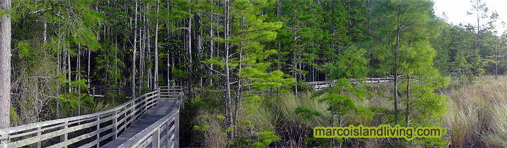
Image: The boardwalk at the Sanctuary will take you through a transitional zone between pond cypress and wet prairie ecosystems
Image source: United States Geological Survey, Center for Coastal Geology
As elevation changes, so do the ecosystems. Ecosystems meet in an area called an ecotone. In many instances, an ecotone will have a mixture of flora and fauna endemic to both adjoining ecosystems, but some transition abruptly. Often, the make-up of the ecotone is due to geologic forces that shape the environment. Stochastic events, such as fires and droughts, also shape transitional areas. Observe the transition from one ecosystem to another, and notice either a mixed ecosystem or an abrupt transition.
Ecosystem #1: Pine Flatwood
On your adventure, you will be introduced to a pine flatwood ecosystem. Pine flatwoods once covered over fifty percent of Florida’s total land area. This ecosystem is home to a diverse community of flora and fauna. Immediately, you should notice the signature pine to Southwest Florida, the slash pine (Pinus elliottii).
Elevation: The pine flatwoods are an example of a Florida upland ecosystem, and are found at some of the highest elevations in Southern Florida. Much of the overland flow and interflow from the pine flatwoods fills the lowland ecosystems, such as the swamps, marshes, and prairies.
Soil composition: The soil of a pine flatwood ecosystem has moderate porosity and high permeability, and as such, the ecosystem is less likely to become saturated as precipitation is quickly absorbed and removed through interflow and infiltration into the zone of saturation. The soil is mostly sandy and is interspersed with cap rocks made of sandstone or limestone. Coarse sand and stone allow water molecules to easily flow through the spaces between grains.
Most of the time, there is very little water-retaining organic matter in the soil matrix. Fires, from prescribed burns or lightning strikes, help contribute to the organic content of the soil. Without fires, the ecosystem would receive little in the way of free organic matter. The soil is nutrient-poor and acidic, and, after an abundance of nutrient from a burn, the regrowth of the flatwood ecosystem quickly uses the available nutrient. Fire is necessary for many flatwood plant species’ lifecycles.
Hydroperiod: The pine flatwood ecosystem is colloquially termed the “high and dry” Florida ecosystem. It has the shortest hydroperiod of the other ecosystems, becoming saturated for only a short period during the peak of wet season. For this reason, it is termed a xeric, or predominantly dry, ecosystem. Rainfall is converted to interflow, supplying the surrounding, lower-lying ecosystems, or will escape through evapotranspiration.
Ecology: Besides the slash pine, look for the saw palmetto (Serenoa repens), a long-living, palm-like bush that grows close to the ground. DNA evidence suggests some long-lived clumps might be several thousand years old. The fruit nurtures the diverse fauna in this ecosystem, and the hearts and berries are edible, and have been used in alternative medicine. Similar to the saw palmetto is the sabal palm (Sabal palmetto). You can differentiate the two by observing the leaf stem. The leaf stem of the saw palmetto ends abruptly at the beginning of the fan-shaped leaf blades and the sabal palm's leaf stem extends the length of the leaf blades.

Image source: University of Florida School Forest Resources and Conservation
Pine flatwoods are home to a diverse array of animals, some which you will encounter on your adventure. As for mammals, the flatwoods sustain populations of squirrel, rabbit, fox, raccoon, opossum, the nine-banded armadillo (Dasypus novemcinctus), and the endangered Florida panther (Puma concolor coryi). Be on the lookout for the pileated woodpecker (Hylatomus pileatus). The pileated is the largest extant woodpecker in the United States. Look for a bright red head and listen for a distinctive call, reminiscent of a laugh.
Ecosystem #2: Cypress Swamp
You will come across the tranquil and beautiful ecosystem termed the cypress swamp. Cypress swamps comprise about ten percent of the land area in Florida. The cypress swamp ecosystem gets its name from the cypress trees that majestically grow from the peaty soils. Cypress will be the largest trees you will observe on your adventure; both in height and girth. Note the cypress knees, which are projections of the cypress root system thought to both anchor the tree and provide oxygen to the roots when the trees are in surface water.
Elevation: The cypress swamp ecosystem is intermediate in elevation; lower than the upland flatwoods and higher than the lowland wetlands. The swamp will receive interflow and overland flow from upland ecosystems, but will marginally feed lowland ecosystems with interflow and overland flow.
Soil composition: Decaying cypress needles and logs, as well as contributions from the vegetative canopy, contribute to a deep layer of organic, water retaining, peaty soil. If you are visiting during wet season, you will notice that the surface water appears reddish-brown. This is due to the tannin content in the slowly-decaying biomass. Low water turbulence and partial decay of organic material uses up much of the available (dissolved) oxygen in swamp water, creating anoxic (oxygen-deprived) conditions. Anoxic conditions limit the extent of further decay of organic material because decomposers do not quickly break down the organic materials, allowing layers of sediment to build up. Cypress swamp soil is considered nutrient-poor because there is very little complete breakdown of organic matter.
A deep layer of organic, peaty soil is characteristic of a cypress swamp. This soil quickly becomes saturated as interflow is impeded by the low permeability of peat. Because of peat’s ability to store water, the ecosystem will have wetter soil and longer hydroperiods than ecosystems with sandy soils.
Hydroperiod: The cypress swamp might have the longest hydroperiod of any ecosystem you observe today. Cypress swamps often remain wet for 75% of the year. Not only does the soil store water and impede its flow elsewhere, but also, due to the thick canopy that blocks out solar heating, there is less evaporation than other ecosystems. This helps retain more water for longer periods of the year.
Ecology: Corkscrew has two cypress sub-habitats, characterized by either the bald cypress (Taxodium distichum) or the pond cypress (Taxodium ascendens). The difference between these two related ecosystems is due to a very slight change of the area’s elevation or soil content. Pond cypress is often found in flatwood pond and lake margins. Bald cypress habitats are found in lakes, swamps, floodplains, and along streams. Pond cypress thrives in areas that have sandier soils that are more permeable than bald cypress soils. It is often the case when both are adjacent, the bald cypress is found in areas of lower elevation that receive more interflow and overland flow and have a longer hydroperiod.
While closely related, the pond and bald cypress have observable differences. A mature pond cypress is often smaller in girth and height than a bald cypress. The easiest way to discern between the two is by comparing the leaves. Pond cypress leaves (needles) press against the branchlet and bald cypress leaves fan out from the branchlet. Both are deciduous, as they lose their leaves during the winter months.
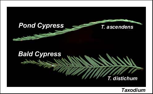
Image source: Planting Pinellas
Your waypoint for this ecosystem will bring you to an area of bald cypress in a cypress "lake." Look for the American alligator (Alligator mississippiensis) along with a number of water birds. This area is home to the protected wood stork (Mycteria americana), and you might be redirected from the regular boardwalk route during its breeding season. If you see a water bird roosting in a tree, you are likely looking at the yellow-crowned night heron (Nyctanassa violacea). This area is also home to three nesting pairs of barred owl (Strix varia) and a very friendly limpkin (Aramus guarauna), who feasts on the abundant apple snails (Ampullariidae spp.).
The flora in this ecosystem is distinctive. Look for an abundance of epiphytes. Epiphytes are plants that grow alongside the cypress trees, often attaching to the trunk or branches. Look for various species of Tillandsia, which are commonly referred to as “air plants.” They bear similarity to a pineapple plant, as they are all bromeliads. Within the area of the waypoint, you should be able to observe both the largest and smallest species of fern in the area. The leather fern's (Acrostichum danaeifolium) fronds can grow up to 12' long and 5' wide, while Salvinia minima has leaves that are no longer than 2 cm in length. Also, be prepared with binoculars to observe the rare and elusive ghost orchid (Dendrophylax lindenii), and be sure to brag if you observe this leafless epiphyte in bloom (generally in June and July)!

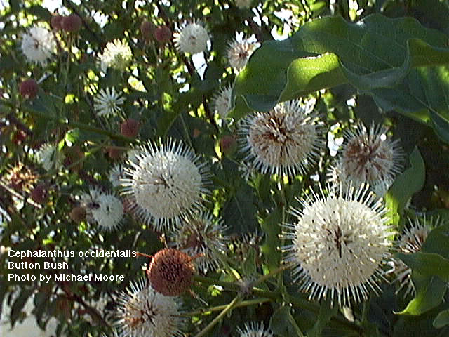
Image source: Rod Wiley - Audubon Florida (At Corkscrew Swamp Sanctuary)
Ecosystem #3 Wet Prairie
Marshes are a type of wetland, which are transitional zones between bodies of water and land. There are nine types of Florida marsh ecosystems, with wet prairies being one of the most abundant in the Southwest Florida area.
The wet prairie ecosystem is essential to both human and non-human life. In fact, this ecosystem has the greatest diversity of life of all ecosystems in Florida. Wet prairies might contain up to 20 distinct species per square meter. Abundant water favors the proliferation of vegetation, which provides food and shelter to many aquatic, terrestrial, and avian animals. A healthy wet prairie also provides important benefits to surrounding ecosystems. The vegetation helps sequester and absorb pollutants and heavy metals, which improves water quality downstream.
Elevation: Wet prairies, like all marshes, are considered lowland ecosystems. Wet prairies receive water and sediment from upland ecosystems such as the pine flatlands and the cypress swamp. The marsh is flat or lightly sloped. The corresponding waypoint will take you to the highest margin of the marsh. The elevation decreases approximately a half an inch as you progress further south into the marsh.
Soil content: Wet prairies in Southwest and South-Central Florida have soils comprised of fine-grained sand. The sand is usually finer-grained than a pine flatwoods ecosystem, and so is less permeable to water flow. Both fine sand (fine) and sandy loam (finer) are common in Southwest Florida's wet prairie ecosystems, with loamy wet prairies retaining more water since they are of lower permeability.
A thin layer of peat (often only a few centimeters) from decaying organic matter is characteristic of a wet prairie’s soil. Peat buildup does not occur because the nutrients and organic matter quickly decay are recycled, or become runoff sediment to lowland ecosystems. Compared to the pine flatwoods, the wet prairie soil will retain more water (the wet prairie is less permeable), but compared to the cypress swamp, surface water is more quickly removed through interflow (the wet prairie is more permeable).
Hydroperiod: The wet prairie will have the second shortest hydroperiod of all four ecosystems you observe today and also the shortest hydroperiod of any Florida marsh ecosystem. Evapotranspiration and permeable sandy soil shorten the amount of time that the soil is saturated. A wet prairie typically has surface water for between 50 and 150 days of the year, occurring during the peak of wet season. The wet prairie is also categorized as short-hydroperiod prairie or wet prairie on sand because of this.
Ecology: When observing the prairie, you will notice the absence of hardwood growth. Grasses dominate the landscape, and the prairie ecosystem is colloquially termed a “sea of grass.” Fires during the dry season cycle out hardwoods and other slow-developing plants, leaving faster-growing grasses and shrubs to dominate the landscape.

There is a great diversity of plant-life in the wet prairie. Look for maidencane (Panicum hemitomon), cordgrass (Spartina bakeri), beakrush (Rhynchospora spp.), and muhly (Muhlenbergia fillipes). The area is rich in amphibian diversity that inhabits the ecosystem for all or part of the year. Look for the green tree frog (Hyla cinerea), Florida red-bellied turtle (Pseudemys nelsoni), and American alligator (Alligator mississippiensis). The prairie is also frequented by larger mammals, such as the white-tailed deer (Odocoileus virginianus) and the endangered Florida panther (Puma concolor coryi), birds such as the green (Butorides virescens), tri-colored (Egretta tricolor), and blue heron (Egretta caerulea and Ardea herodias) and white ibis (Eudocimus albus), and a multitude of insects, such as the dragonfly, including the year-long Florida resident Halloween pennant (Celithemis eponina).
Ecosystem #4: Basin Marsh
A basin marsh is a type of marsh characterized by a large and irregular shaped basin, or depression. These marshes develop from depressions that were once shallow lakes that have dried and have been filled by vegetation. Often, portions of basin marshes have permanent surface water, which are called marsh lakes.
Elevation: The basin marsh that you will observe has formed from a depression in the bedrock and soil. It will likely have the lowest elevation of the surrounding ecosystems. Overland flow and interflow from upland ecosystems will fill the marsh during the wet season. Because the marsh exists in a depression, it is bordered in all sides by areas upland of it. Surface water remains for longer periods of time because interflow and overland flow out of the marsh do not occur. Water will be removed from this ecosystem only though evapotranspiration and infiltration into the zone of saturation.
Soil composition: Basin marshes have some of the lowest elevations of any inland Florida ecosystem. As such, they receive overland flow with suspended sediment from upland ecosystems. Much of this sediment is organic matter, which increases the peat content of the soil. Plants with shorter life-spans, like grasses, and frequent burns also contribute to the organic peat soil. The peat layer is not as thick as the cypress swamp, as active decay recycles nutrients.
A layer of peat makes the marsh slightly acidic, and creates a system where surface water is present for most of the year. Most basin marshes (including this one) also contain finer grained particles, including silt, which decreases the permeability and increases the porosity of the soil. Some basin marshes that exist as the headwaters of a river, such as the St. John's Basin in Florida, have more sandy soil content, granting greater permeability of water to flow to the river.
Hydroperiod: Of all four ecosystems that you will observe today, basin marshes have the second-longest hydroperiod - generally around 60% of the year. Because the basin marsh is surrounded by higher land, water flows into, and remains, in the marsh. Finer grained soils that include peat are more porous and less permeable than the soils in the wet prairie and pine flatwoods. In relation to the cypress swamp, there is a faster rate of evapotranspiration that removes water from the ecosystem, and the layer of peat is not as deep.
Ecology: The organic, fertile soil provides nutrients for grassy, herbaceous, and shrubby plants. Typical plants include common reed (Phragmite spp.), Panicum, southern watergrass (Luziola fluitans), elderberry (Sambucus spp.), buttonbush (Cephanlanthus occidentalis), and dog fennel (Anthemis cotula). These are all water-tolerant plant species.
During the dry season, the basin marsh has a tendency to burn, which cycles out hardwood species and returns the marsh to faster-growing grasses and shrubs. The plant varieties in these marshes are a key to determining the period of time since the last major burn. Note that grassy plants take less time to develop than shrubs, which in turn take less time to develop than hardwoods. The normal interval of fire is between one and ten years. Grassy marshes burn every one to three years, while those with predominantly shrubby vegetation burn between three and ten years. If the marsh has not burned in over ten years, examples of mature hardwood species might be present.
The waypoint for the basin marsh will take you to an ecotone overlooking the basin to the west. Here you will see examples of hardwood, including the red maple (Acer rubrum). Consider when the last burn probably occurred based on the types of plants you observe.
Your Mission
To receive credit for this EarthCache, please answer the following questions. Please send them directly to me via email (Direct Email Link) no later than one week after posting your “Found it” log. Logs without answers will be deleted, as per EarthCache guidelines. If your answers are incorrect or incomplete, I will advise which answers need correction. Please do so in a timely manner so that your log is not deleted.
1. WAYPOINT #1 (facing south)
- Is there surface water at this waypoint?
- If there is no water, observe and report what the soil looks like. Is it sandy and light, or organic and dark? Please do not disturb any vegetation or soil for this observation.
- If there is no surface water, are there signs that the soil is moist? For instance, does the soil look muddy or wet, is the vegetation green or brown, does the area smell like decay (characteristic of moisture), and so forth.
- Using the kit, report the water depth to the inch range.
- Using your system-appropriate altimeter, report the elevation of this waypoint to a fraction of an inch. You may check your measurment by clicking the following link and typing in the answer to this question: This seven-lettered word is defined as the transitional zone between two ecosystems that often contains elements of both ecosystems.

You can validate your puzzle solution with certitude.
- Take a moment and observe the ecosystem using your senses. Report five observations you've made during this moment.
2. WAYPOINT #2 (facing northwest)
- Is there surface water at this waypoint?
- If there is no water, observe and report what the soil looks like. Is it sandy and light, or organic and dark? Please do not disturb any vegetation or soil for this observation.
- If there is no surface water, are there signs that the soil is moist? For instance, does the soil look muddy or wet, is the vegetation green or brown, does the area smell like decay (characteristic of moisture), and so forth.
- Using the kit, report the water depth to the inch range.
- Using your system-appropriate altimeter, report the elevation of this waypoint to a fraction of an inch. You may check your measurment by clicking the following link and typing in the answer to this question: This eight-lettered word is a measure of the empty space in soil

You can validate your puzzle solution with certitude.
- Take a moment and observe the ecosystem using your senses. Report five observations you've made during this moment.
3. WAYPOINT #3 (facing southeast)
- Is there surface water at this waypoint?
- If there is no water, observe and report what the soil looks like. Is it sandy and light, or organic and dark? Please do not disturb any vegetation or soil for this observation.
- If there is no surface water, are there signs that the soil is moist? For instance, does the soil look muddy or wet, is the vegetation green or brown, does the area smell like decay (characteristic of moisture), and so forth.
- Using the kit, report the water depth to the inch range.
- Using your system-appropriate altimeter, report the elevation of this waypoint to a fraction of an inch. You may check your measurment by clicking the following link and typing in the answer to this question: This eleven-lettered word is defined as the duration of the year that there is surface water in an area.

You can validate your puzzle solution with certitude.
- Take a moment and observe the ecosystem using your senses. Report five observations you've made during this moment.
4. WAYPOINT #4 (facing northeast)
- Is there surface water at this waypoint?
- If there is no water, observe and report what the soil looks like. Is it sandy and light, or organic and dark? Please do not disturb any vegetation or soil for this observation.
- If there is no surface water, are there signs that the soil is moist? For instance, does the soil look muddy or wet, is the vegetation green or brown, does the area smell like decay (characteristic of moisture), and so forth.
- Using the kit, report the water depth to the inch range.
- Using your system-appropriate altimeter, report the elevation of this waypoint to a fraction of an inch. You may check your measurment by clicking the following link and typing in the answer to this question: This twelve-lettered word is defined as a property of soil that pertains to its ability to allow for water to flow through it.

You can validate your puzzle solution with certitude.
- Take a moment and observe the ecosystem using your senses. Report five observations you've made during this moment.
5. Using the information above and your observations, make a conclusion as to which ecosystem above corresponds to Waypoints #1, 2, 3 and 4.
6. For each of the four waypoints, what role does elevation play in shaping the hydroperiod? What role does soil content play in shaping the hydroperiod? Does one have a greater impact than the other? Four answers, one for each of the waypoints, are expected here!
Happy hunting!
-THT

*****Congratulations to jrcbec for the FTF!****