
This Cache:
The nearly vertical Nockamixon cliffs are a spectacular geologic site along the Delaware River. Standing at GZ there are some information plaques that you may obtain addition and necessary information from to claim this Cache.
You perhaps wonder how these cliffs were formed. Let's take a trip in the Space 2081 Time Machine:
4.5 million years ago the Earth was formed.........That's a little too early, let's fast forward quite a bit in our time machine. During the Mesozoic (252 to 66 million years ago. It is also called the age of reptiles ), the east coast of North America was once as wild as the Himalayas, with massive mountains rising between colliding tectonic plates, volcanoes belching lava and giant faults slicing the crust. That's because millions of years ago, eastern North America was part of Gondwana and later Pangaea, the supercontinents that formed as Earth's tectonic plates collided, split apart, and then crashed together again before rifting and drifting toward the spots where they're located today. A shallow sea was formed.
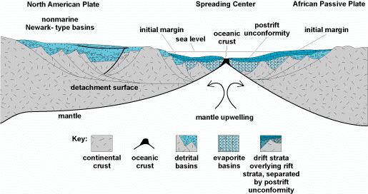 The Split of the African and North American tectonic plates
Though North America's east coast is relatively quiet now, clues to these ancient tectonic mash-ups remain buried deep underground. Some of which are exposed here, due in part melting waters from the Ice Age forming the Delaware River The last collision of ancestral North America and ancestral Africa formed mountains as tall as any on Earth today (this last mountain building in this area is called Allegheny orageny). This formed the Piedmont area to the east of the Allegheny plateau.
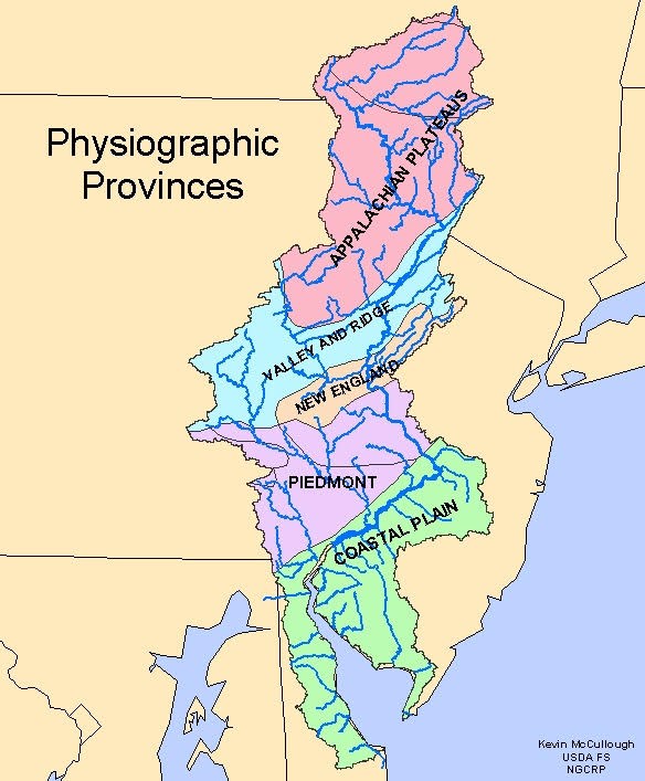 The Piedmont area in PA
These mountains stood proudly, their majestic peaks 30,000 feet above sea level; eastward from the mountains lay a shallow sea in this area and to the East. Periods of torrential rain alternated with scorching dry spells, as many as 10,000 of them, some periods a century in length. As the rain tore at the bone-dry mountains, erosion carried unimaginable quantities of silt, sand and clay easterly toward the sea, gradually building up a plane that spread south and east from the mountains, displacing what would become Atlantic Ocean. These sediments, known as the Newark sediments,formed in Late Triassic and Early Jurassic this created the Triassic Basin. The uppermost of them, called the Passaic (formerly know as the Brunswick -so named for its outcroppings along the Raritan River at New Brunswick). A soft red shale mixed with sandstone, it is the loose sediment worn by the rains and rivers from the shale and sandstone mountains to the west, and then compressed by the forces of nature and time into stone again.
The hard sand stone resisted weathering once compressed (metamorphosed) into harder rocks leaving the cliffs as you see here exposed by the Delaware River Toward the end of the Triassic Period (200 million years ago)d, molten magma from deep with the earth’s crust flowed into these beds of sedimentary rock. The “igneous intrusions” heated the surrounding sandstone and shale, changing them into tough, weather-resistant rock called hornfels The resulting red sandstone and shale can still be found throughout the region. They are reddish and break easily into flakes and fragments During the Jurassic Period (200 to 145 million years ago), the region was subjected to continuous erosion. While some other rock, such as the sandstone and shale were worn away, the hardest shale and hornfel resisted weathering, allowing the Nockamixon Cliffs to “rise” above the surrounding landscape. .
The cliffs are composed of unusually hard shale, siltstone, and sandstone of the Passaic ( Brunswick) Formation (Triassic age). They are an outstanduing feature of the Gettysburg-Newark Lowland Section of Pennsylvania comprised of of rolling low hills and valleys developed on red sedimentary rock. Here are higher hills developed on diabase, baked sedimentary rock (hornfels), and conglomerates. Almost all of the underlying sedimentary rock dips to the north or northwest and many of the smaller drainageways are oriented normal to the direction of dip so that some of the topography has a northeast-southwest linearity. However, the basic drain-age pattern is dendritic (dendritic: drainage patterns that look like tree branches with lots of twigs ). Soils are usually red .
These rocks form near-vertical cliffs because they have been partially metamorphosed by the nearby Coffman Hill diabase sheet (About 200 million years ago, a dark igneous rock called diabase was injected into the basin in the form of magma. The heat associated with the Coffman Hill diabase sheet baked the rocks of Nockamixon into dense, resistant rocks and are therefore denser, harder, and more resistant than similar rocks to the northwest of Kintnersville. The harder metamorphized rocks are known as hornfels. Hornfels(German, meaning "hornstone") is called so because of its exceptional toughness and texture both reminiscent of animal horns. These properties are due to fine grained non-aligned crystals with platy or prismatic habits. Hornfels is the group designation for a series of contact metamorphic rocks that have been baked and indurated by the heat of intrusive igneous masses and have been rendered massive, hard, splintery, and in some cases exceedingly tough and durable.
As Africa separated from North America about 250 million years ago, streams dumped sediment into a stretched depositional basin during the Triassic Period. Coarse-grained sediments accumulated along the basin edges. Rivers laden with pebbles and sand built alluvial fans. Finergrained sediments settled in lakes.
During the winter, the cliffs are often covered in ice from seeping water. No climbing is permitted. As these are north facing the have some rare and endangered plants, do not enter the cliff area. The climate was generally warm but variable; dinosaurs passed through the region. Faulting and folding of these rocks occurred as the basin was tilted to the northwest. Over a long time, the rocks have been exposed and eroded. Their resistant nature is reflected in the sharp topographic breaks along the Delaware River. Differential weathering is the physical and chemical breakdown of different rock units at different rates. Opening of the joints and curved fractures was probably initiated by frost wedging and solution (the rock is slightly limy) and accentuated by soil wedging and gravitational creep.
Questions:
What is your guess as to why the cliffs are this color?
Are there layers visible ? And if so are they horizontal or tilted and in which direction and about how many degrees tilt?
What is biggest force here that wore away the cliffs and exposed them do you suppose?
What other force might expand the cracks here and cause erosion?
How high above the river do you estimate the cliffs?
What color are the cliffs? Are they all the same color?
And finally, your SPACE2081 code. If you want to complete the series, be sure to collect this! What landmark did you walk over en route to the coordinates (It's made of cement, and it's NOT the D&R canal.) Record this answer, as it's your SPACE2081 code for this cache. There is also a picture below to confirm that you have it correct. This answer is not required in the message to confirm that you were at the GZ.
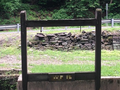 A landmark near the coordinates for this Earthcache with the code on it. The code of course, has been blurred out.
Please message your answers to SPACE2081 on geocaching.com.
A landmark near the coordinates for this Earthcache with the code on it. The code of course, has been blurred out.
Please message your answers to SPACE2081 on geocaching.com.
References:
Inners, J. D., 1980, Nockamixon State Park, Bucks County—Rocks and joints: Pennsylvania Geological Survey, 4th ser., Park Guide 14.
Olsen, P.E., 1980. The Latest Triassic and Early Jurassic Formations of the Newark Basin (Eastern North America, Newark Supergroup): Stratigraphy, Structure, and Correlation. New Jersey Academy of Science Bulletin, v. 25, no. 2, p. 25-51.
Berg, T.M., Edmunds, W.E., Geyer, A.R. and others, compilers, (1980). Geologic Map of Pennsylvania: Pennsylvania Geologic Survey, Map 1, scale 1:250,000.
Faill, R.T., (2004). The Birdsboro Basin. Pennsylvania Geology V. 34 n. 4
Berg, T.M., et al., (1983). Stratigraphic Correlation Chart of Pennsylvania: G75, Pennsylvania Geologic Survey, Harrisburg.

This Series:
This cache is part of the SPACE 2081: A Geocaching Odyssey challenge.
This challenge contains one cache of each difficulty and terrain combination, plus a final cache which can be found only after finding all 81 caches that are part of the series. Each of those 81 caches will contain a code, which you will use as part of the puzzle to solve the FINAL CACHE.
All the members of the space team are actual cachers who are remaining anonymous for the moment. You can find more info on the series, as well as a complete list of released caches HERE. Please do not post hints or spoilers in your logs. Also, each cache must be signed by any individual cachers going for the final.
Good luck, may the force be with you, live long and prosper.
Space Online: