Pine Flats:
Hot dips and cliffside showers near a family campground, on the South Fork Payette River. Bathing suits required. A cascade pouring over a cliff decorates one side of a pool hidden 20 feet above the river. This one is big enough to pack a couple of human sardines side by side and hot enough to turn them into lobsters. Cooler pools at the bottom collect the runoff, and a large swimming hole at the river’s edge adds the final touch. Those who prefer more privacy can wade along the base of the cliff in late summer to find yet another hot pool with a shower hidden in the rocks just around the bend.
The Idaho Batholith, a granite formation fractured by faults. Through each fault, hot water from deep in earth’s core rushes up, spilling out onto the surface, creating pools, mixing with streams, making steamy gathering places for the weary adventurer.
As a result of the faults, Stanley is surrounded by hot springs. Whether at the destination of a long hike or right next to the road out of town, the hot springs of Stanley bring an essence of paradise to the area.
Geothermal Sources:
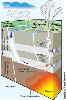
A hot spring is a spring that is produced by the emergence of geothermally heated groundwater from the Earth's crust. There are geothermal hot springs in many locations all over the crust of theearth.
The water issuing from a hot spring is heated by geothermal heat, i.e., heat from the Earth's mantle. In general, the temperature of rocks within the earth increases with depth. The rate of temperature increase with depth is known as the geothermal gradient. If water percolates deeply enough into the crust, it will be heated as it comes into contact with hot rocks. The water from hot springs in non-volcanic areas is heated in this manner.
Mineral Deposites Common to Hot Springs
Hydrothermal landforms—hot springs, geysers, fumaroles, and mud pots—are primarily found above areas in the crust where magma or molten rock has risen to a shallow depth beneath the surface. In such instances, the magma may exist in a chamber or reservoir 3 to 6 miles (5 to 10 kilometers) beneath Earth's surface. This magma may be part of heated rock from a convection current or may be part of the leading edge of a plate that has moved under another plate. Geologists called this type of plate movement subduction. It occurs when an oceanic plate moves into another oceanic plate or into a continental (land) plate. Because the oceanic plate is dense, it slides under the other plate. As it travels downward into the mantle, high temperature and pressure melt the rock at the leading edge of the plate, forming thick, flowing magma. Since it is less dense than the rock that typically surrounds it deep underground, magma tends to rise toward Earth's surface. Driven by pressure created by gas bubbles within it, the magma forces its way through weakened layers of rock to collect in magma chambers. Sometimes pressure builds up within the chamber, forcing the magma through cracks or vents onto the surface of the planet. The vents through which the magma passes are known as volcanoes.
In fact, most hot springs, geysers, fumaroles, and mud pots are found in regions where volcanic activity is very young or has become inactive. In both cases, hot magma does not erupt onto the surface of the planet but exists to heat groundwater that enters the region above it. For example, geologists believe an incredible volcanic explosion 600,000 years ago left a partially molten magma chamber beneath the central portion of present-day Yellowstone National Park. It continues to supply the heat that helps create the many and varied hydrothermal landforms that mark the park. Geologists estimate that rocks in old magma chambers may remain hot for one million years or more.
Normal hot springs do not erupt, but may seem to churn and "boil" as gases from underground pass through them. When the water that feeds a hot spring passes through rocks underground, it may dissolve minerals from the rocks and bring them to the surface.
Geyserite: A white or grayish silica-based deposit formed around hot springs.
Rhyolite:A fine-grained type of volcanic rock that has a high silica content.
Travertine:A dense, white deposit formed from calcium carbonate that creates rock formations around hot springs.
Logging this EarthCache:
1. You will need to visit both the upper and the lower pools to gather information. Note the coords can get bouncy in this area, but there is a trail/path to both pools. Be mindful and watch your step though, the terrain can be rough.
2. Take a temperature reading in both the upper an lower pools.
3. Calculate the temperature difference between the two.
4. Why do you think the temperatures vary between the two pools? Utilizing the description of how geothermal springs function and form, how the the water heated and that forms these springs?
5. You may notice white, chalky deposits and the flaky stones around the area. In your best estimate what kind of mineral is this?
6. Email the temp of both pool plus the difference between the two upon your visit with the answer as to why you believe this temperature difference occurs. Also email you answer to the types of stones in the area. Email the number and geo-names of those in your part, one email will suffice for the group.
OPTIONAL. Have fun and post a pic of your trip.
Tools Needed:
1. Thermometer (Or some way to accurately take water temperature.
2. Bathing suit (This is just if you plan on lounging around after the hike and relaxing)
Other than the first item though, it is really up to you. Have fun and enjoy nature. Also, take advantage of the other nearby cache.
Sources:
"Science Clarified." Geyser and Hot Spring. N.p., n.d. Web. 12 May 2015.
"Stanley Area Hot Springs - Stanley Sawtooth Chamber of Commerce." Stanley Sawtooth Chamber of Commerce. N.p., n.d. Web. 14 Aug. 2015.
National Forest Services and the local region director has been notified about and is aware of the placement of this cache and permission has been given for its placement. This cache is near the Pine Flats camping area and is in a public access area, the hot springs are open to the public. There is parking at the camping area but you have to hike into the hot springs, so remember to pack out what you pack in, help to keep the place clean.