H O L L I N G B O U R N E
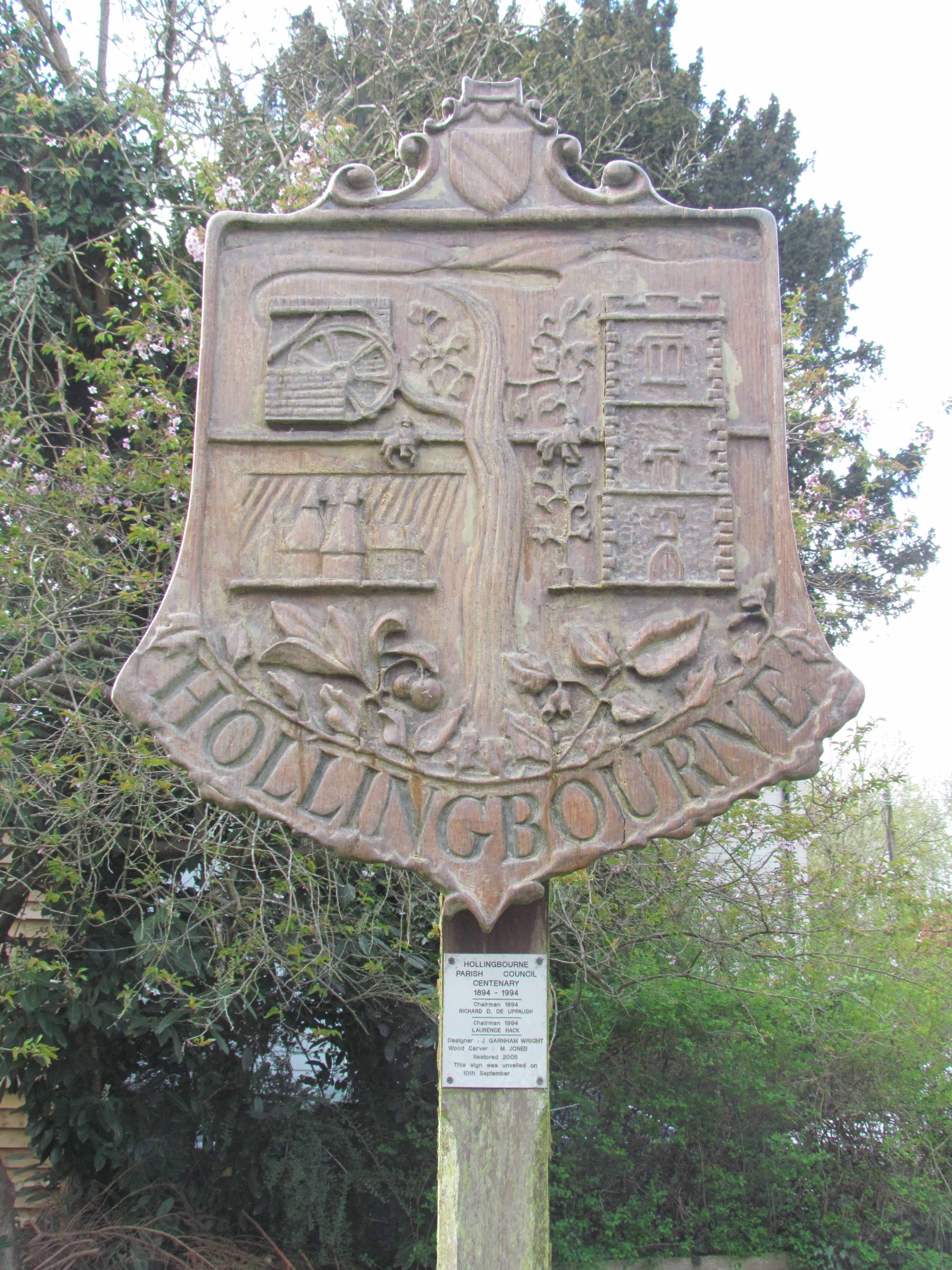
The name Hollingbourne may derive either from "the bourne of Hola's people" or "the bourne of the people in the hollow". The River Bourne (or Snagbrook Stream) runs through the village further down Eyhorne Street from the Village Sign. The village nestles under the North Downs some five miles to the east of Maidstone.
Within the village lie three historic settlements that date back to Anglo Saxon and Roman times. These three distinct village-groups are still very much recognisable today - Broad Street, Eyhorne Street and Upper Street. Virtually every building in these settlements has been listed as having special architectural or historic interest, in fact there are 106 such listings including a Grade I Church, as Grade 1 Manor House and two exceptional timber framed Tudor houses listed as Grade II.
Hollingbourne today is a village with a population of around 900. It has over one hundred listed buildings and two conservation areas and is surrounded by several sites of special scientific interest. There are spectacular views across the village and Kent towards the South Downs from the top of Hollingbourne Hill.
The information you need to find the location of the cache is all to be found on the village green at the listed co-ordinates:
The Hollingbourne Village Sign was unveiled on 10th September ABCD
William Cobbett said of Hollingbourne “This is what the people of Kent call the garden of England” in his book, “Rural Rides” in the year EFGH
The North Downs Way is one of JK National Trails in England and Wales forming part of the South East Walks Network.
The cache can be found about 5 minutes stroll away from here at the following co-ordinates:
N 51 JK.(C-G)(D+H+E)(F)
E 000 H(B-A-E).DGG
It is a small green click-lock type container originally containing a few fun items, a trackable to be moved on (please)
and an unregistered travel bug for the FTF. Congratulations to Timmeh McGee for being FTF.
About Village Sign Caches
|
 ⠀ ⠀ |
This cache belongs to the Village Sign Series, a series of caches based on ornate signs that depict the heritage, history and culture of the villages that put them up (generally on the village green!).
The signs can be made of different materials from fibreglass to wood, from forged steel to stone. They can depict anything from local industry to historical events. The tradition probably started in Norfolk or Suffolk and has now spread across most of the country so we thought we would base a series on them!
|
More information, bookmarks and statistics can be found at the Village Signs Website
If anybody would like to expand the Village Sign Series, please do.
I would ask that you request a number for your cache first at www.villagesignseries.co.uk
so we can keep track of the Village Sign numbers and names to avoid duplication.