| I have earned GSA's highest level: |
 |
Shifting Sands Earthcache
Pinellas County coastline is bordered by 35 miles of sandy beaches on 11 barrier islands along the Gulf of Mexico. The barrier islands provide a natural protection to the mainland. Some of these islands are preserved for the environment or historical significance, while others are developed. The barrier islands are separated by inlets also called passes. They serve as an outlet for freshwater discharged from the land, and an outlet for storm tides developed within the estuaries They are buffers from the storm tides that develop in the gulf and they are a channel for water exchange in response to astronomical tides. Barrier islands and inlets work together as part of a natural system.
The barrier islands located along the Gulf coast of Pinellas County form a string of long narrow strips of sand, separated from the mainland by bays and estuaries varying from less than 30 meters to more than 600 meters in width. These islands are termed barriers because they protect the mainland from the direct effects of major storms. Barrier islands are one of the most dynamic landscapes on earth. Until approximately 4,000 to 5,000 years ago, the shoreline of Pinellas County was 10’s to 100’s of kilometers to the west. As the sea level has gradually risen due to the continued retreat of the glaciers, the shoreline has retreated to its current location. One explanation for the barrier island formation is that submarine sand bars become subaerial barriers by upward accretion of sand and other deposits.
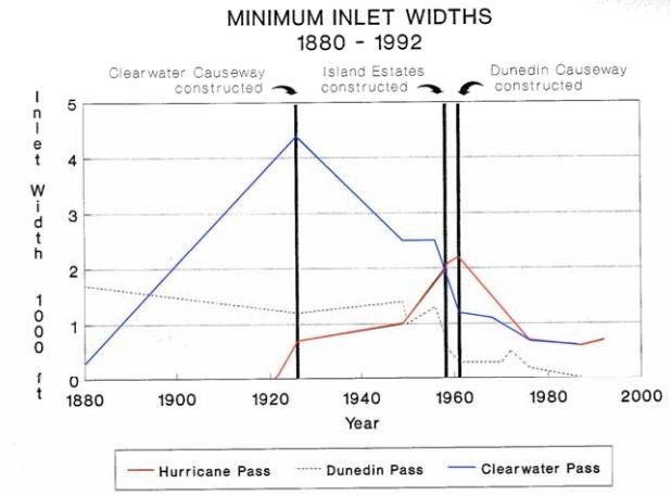
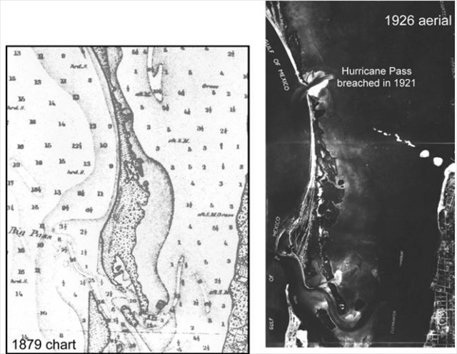
Dunedin Pass (also known as Big Pass) was the inlet that separated Caladesi and Clearwater Beach islands. It was the dominant inlet serving St. Joseph Sound (the back barrier bay in northern Pinellas) prior to the hurricane of 1921, one of the most severe on record for the west coast of Florida. When the hurricane came through it opened up Hurricane Pass to the north. The combination of this natural event and significant changes in tidal circulation in St. Joseph Sound led to the destabilization of Dunedin Pass. Local construction redirected the tidal flow away from Dunedin Pass. After the 1921 hurricane, Dunedin Pass migrated over 1 km to the north as the spit on the north end of Clearwater Beach Island extended. Shoaling became a persistent problem. In 1985 the passage of Hurricane Elena generated 2.5m waves and eroded the ebb delta (shoal) of Dunedin Pass. Without the protection of the ebb delta, tidal flow was not sufficient to maintain the inlet and the pass shoaled and closed in 1988. After Hurricane Elena, Caladesi Island (no longer an island) and Clearwater Beach became one continuous stretch of land and you can access Caladesi by walking north from Clearwater Beach.
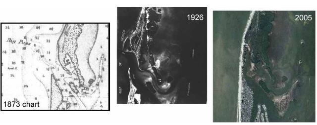
Hurricane Pass (between Caladesi and Honeymoon Island) was created by the hurricane of 1921. Prior to the hurricane, Caladesi and Honeymoon Island were part of a large barrier island. When the 1921 hurricane came through, it split the barrier island into two parts and created Hurricane Pass. White the shoreline of Honeymoon Island has receded more than 30 feet overall, some portions of the shoreline have advanced. In the northern portion of the island a sand spit and beach ridge have been growing and extending northward. However, erosion has occurred in the central and south central areas. On Caladesi some portions of the shoreline have receded an average of 27 feet overall, some reaches have advanced or have not changed in position. With the new pass created by the 1985 hurricane, the northern portion of the island continues to be the most dynamic section of shoreline. Hurricanes from 2000 to 2005 have reorganized the sediment by removing the north end and by creating another new pass in the same location as in 1985.
To log a find for this earthcache email furshore the answers to the following questions:
1. Name four roles that inlets serve.
2. Using your GPS, at GZ, estimate the width of Hurricane Pass from Caladesi Island (south/southwest) to Honeymoon Island (north) and estimate the length of the sand bar extending south from Honeymoon Island.
3. Pictures are welcome but not necessary.
http://www.pinellascounty.org/environment/coastalmngmt/barrier-islands-inlets.htm
http://www.pinellascounty.org/environment/coastalmngmt/pdfs/DunedinPassHistory.pdf
http://www.pinellascounty.org/environment/coastalmngmt/pdfs/HoneymoonIslandHistory.pdf
http://en.wikipedia.org/wiki/Caladesi_Island_State_Park
https://www.pinellascounty.org/Plan/comp_plan/05coastal/ch-2.pdf
Congratulations to FloridaPanther FTF!!