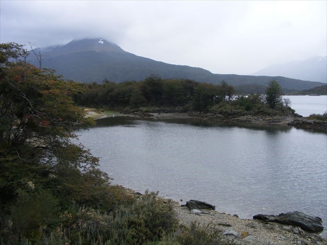
To be able to make the observations necessary to log this Earthcache you have to get to the listing co-ordinates, which are as far as you can go beyond the end of the National Route 3, walk the short trail to the Black Lake & pay a visit to the Alakush Centre. It is possible to reach the end of the National Route 3 by a regular bus service from Ushuaia and then walk or take the bus to visit the 2 other places.
Para poder realizar las observaciones necesarias para registrar este geológica caché que tiene que llegar a la lista de coordenadas, que son lo más lejos que puede ir más allá del final de la ruta nacional 3, caminar por la corta pista a la Lago Negro y pagar una visita al Centro Alakush. Es posible llegar a la final de la ruta nacional 3 por un servicio regular de autobuses desde Ushuaia y luego caminar o tomar el autobús para visitar los otros 2 lugares.
ESPAGNOL
El Parque Nacional Tierra del Fuego fue creado en 1960 y protege 68,909 hectáreas del extremo sur de los Andes. La tierra se cubre sobre todo con la haya sur pero hay extensas áreas de turbera y montañas que se elevan a 6.000 pies.
EL CLIMA, LA GEOLOGIA Y GLACIOLOGÍA DE TIERRA DEL FUEGO
El archipiélago de islas que compone la Tierra del Fuego se produjo como parte de la orogenia andina y la tierra ha sido sometida a repetidas glaciaciones del Pleistoceno. Los Andes, son una serie de cadenas montañosas divididas por valles profundos, que funcionan en gran medida de oeste a este, en el que se encuentran los lagos, ríos y turberas.
El clima es templado-frío y húmedo, sin estación húmeda marcada. La precipitación media anual es de alrededor de 25 pulgadas (700 mm) con un ligero pico en otoño. Las temperaturas invernales promedio de alrededor de congelación y la media en verano es inferior a 10 oC. La nieve es abundante y se acumula durante el invierno, especialmente en los valles más profundos.
La formación de los Andes moderna comenzó con los acontecimientos del Triásico, cuando Pangea comenzó a romperse y varias divisiones desarrollado. Continuó a través del período Jurásico y fue durante el período cretáceo que los Andes comenzó a tomar su forma actual, por el que eleva, fallamiento y plegamiento de las rocas sedimentarias y metamórficas de las rocas más antiguas del este. El levantamiento de los Andes no ha sido constante, sino que se debe a las fuerzas tectónicas a lo largo de la zona de subducción, que recorre toda la costa oeste de América del Sur, donde la Placa de Nazca y una parte de la Placa Antártica se deslizan por debajo de la placa de América del Sur. La formación de montañas continúa, lo que resulta en menores hasta mayores terremotos y erupciones volcánicas en la actualidad.
La geología se puede dividir en grandes unidades orientadas este-oeste-de la siguiente manera: Las islas del sudoeste del archipiélago, incluyendo el Cabo de Hornos, son parte del Batolito Patagónico - granito, granodiorita y otras rocas ígneas formadas profundamente en la corteza.
La zona que rodea el Canal de Beagle y la Cordillera Darwin, que contiene las montañas más altas, se compone de rocas metamórficas en gran medida, pero también incluye máfica (roca ígnea) para félsicos (granito) cuerpos ígneos penetraron 151 a 15 Ma, mientras hace.
La ciudad de Tulhuin radica en la actividad sísmica, Magallanes-Fagnano Falla, un dextral fallo por deslizamiento de cruzar la parte sur de la isla principal de oeste a este, que en su mayor parte está ocupada por el Seno Almirantazgo lleno de agua y Lago Fagnano . Lago Fagnano ocupa una depresión glaciar-talladas en una cuenca pull-apart que se ha desarrollado a lo largo de la zona de falla Magallanes-Fagnano.
Al norte de esta fiordo y el lago es la faja plegada y corrida Magallanes con secuencias sedimentarias su mayoría de edad mesozoica. Al sur de las rocas son sedimentos paleozoicos meta en su mayoría. En la región del extremo norte del archipiélago se encuentra el promontorio Magallanes - una antigua cuenca sedimentaria con abundantes reservas de hidrocarburos. ortogneis rocas, de fecha a 525 millones de años, son conocidos por ser la base de algunos de los pozos de petróleo en el norte de Tierra del Fuego.
FLORA
El noreste de Tierra del Fuego está compuesto por estepa y fresco semi-desierto, pero las partes meridionales tienen selva húmeda fría, que crece en suelos clasificados como podzoles y Inceptisoles.
Seis especies de árboles se encuentran en estos bosques: canelo o la corteza de invierno (Drimys winteri), Pickwood (Maytenus magellanica), Pilgerodendron uviferum, la conífera más austral del mundo, y tres tipos de hayas del sur: Nothofagus antarctica, Nothofagus pumilio y el betuloides siempreverde de Nothofagus. Varios tipos de frutas crecen en espacios abiertos en estos bosques, tales como fresa playa (Fragaria chiloensis var. Chiloensis) y el calafate (Berberis buxifolia), que durante mucho tiempo han sido recogidos por los americanos y los residentes nativos de ascendencia europea.
Estos bosques son únicos en el mundo por haber desarrollado en un clima con veranos fríos tales. La cubierta arbórea se extiende muy cerca del extremo sur de América del Sur. Los vientos son tan fuertes que los árboles en las zonas expuestas al viento crecen en formas retorcidas, inspirando a la gente a llamarlos "bandera-árboles".
TAREAS
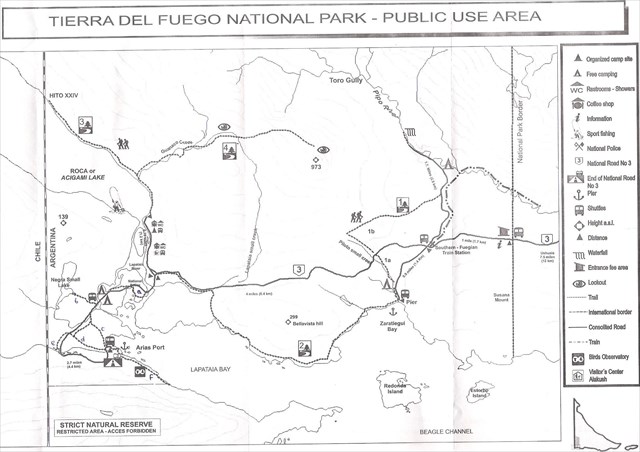
1) A partir de Arias Puerto tomar La boya Alza (Senda de la Baliza) 1,5 kilometros SE, más allá de una colonia de castores activa, a la marca del envío en las coordenadas de la lista. ¿Qué tipo de afloramientos de roca aquí? Es que (a) camas sedimentaria pizarra y piedra arenisca, (b) roca ígnea cristalina o (c) comprimido, metamórficas esquisto?
2) Vuelve sobre tus pasos y camina o cabalga hasta el inicio de la Caminata por el Pequeño Lago Negro (Laguna Negra), que te lleva a una turbera en proceso de formación. Hubo varios avisos a lo largo del sendero, pero C-Squared Pirates me dijeron que ya no hay ninguna señal sobre el turbal/turba. Si no puede encontrar ningún letrero sobre la turba, tendrá que conectarse a Internet para responder las preguntas ligeramente modificadas que aparecen a continuación.
a) Dime qué 2 condiciones impiden la descomposición del material vegetal muerto y otras 2 cosas necesarias para convertir este material vegetal en turba.
b) el 90% de las turberas de Argentina se encuentran en Tierra del Fuego y más del 80 por ciento de las turberas conocidas de Argentina se encuentran en la Península Mitre. Un área algo mayor que ¿a qué país se le otorgó el estatus de protección especial y cuándo?
3) En el centro de visitantes es una excelente área de visualización. Uno de los paneles describe 3 características de la Tierra y su órbita que interactúan y dan lugar a cambios climáticos de glacial para períodos interglaciales y viceversa. Se menciona la longitud de algunos de los ciclos involucrados.
(A) una lista de estos factores y la duración de sus ciclos.
(B) Lo que finalmente produce el calentamiento del clima que conduce a un período interglacial y el retroceso de los glaciares.
Una vez que me ha enviado por correo electrónico sus respuestas usted podrá conectar a su "hallazgo" y yo pondremos en contacto con usted tan pronto como sea posible para hacerle saber lo que ha hecho.
ENGLISH
The Tierra del Fuego National Park was created in 1960 and protects 68,909 hectares of the southern tip of the Andes. The land is mostly covered with southern beech but there are extensive areas of peat bog and mountains rising to 6,000 feet.
THE CLIMATE, GEOLOGY & GLACIOLOGY OF TIERRA DEL FUEGO
The archipelago of islands that makes up Tierra del Fuego were produced as part of the Andean orogeny and the land has been subjected to repeated Pleistocene glaciations. The Andes here are a series of mountain chains divided by deep valleys, running largely west to east, in which are lakes, rivers and peat bogs.
The climate is cool-temperate and damp, with no marked wet season. The annual mean precipitation is around 25 inches (700mm) with a slight peak in autumn. Winter temperatures average around freezing and the summer average is below 10 oC. Snow is abundant and accumulates during winter, especially in the deeper valleys.
The formation of the modern Andes began with the events of the Triassic when Pangaea began to break up and several rifts developed. It continued through the Jurassic Period and it was during the Cretaceous Period that the Andes began to take its present form, by the uplifting, faulting and folding of sedimentary and metamorphic rocks of the more ancient rocks to the east. The rise of the Andes has not been constant but is due to tectonic forces along the subduction zone which runs the entire west coast of South America, where the Nazca Plate and a part of the Antarctic Plate are sliding beneath the South American Plate. Mountain-building continues, resulting in minor to major earthquakes and volcanic eruptions to this day.
The geology can be divided into large east–west-oriented units as follows: The south western islands of the archipelago, including Cape Horn, are part of the Patagonian Batholith - granite, granodiorite and other igneous rocks formed deep in the crust.
The area around Beagle Channel and the Cordillera Darwin, which contains the highest mountains, is composed of largely metamorphic rocks but also includes mafic (gabbro) to felsic (granite) igneous bodies intruded 151 to 15 Ma ago.
The town of Tulhuin lies on the seismically active, Magallanes-Fagnano Fault, a dextral strike slip fault crossing the southern part of the main island from west to east, which for the most part is occupied by the water-filled Almirantazgo Fjord and Fagnano Lake. Fagnano Lake occupies a glacier-carved depression in a pull-apart basin that has developed along the Magallanes-Fagnano Fault zone.
North of this fjord and lake is the Magallanes fold and thrust belt with mostly sedimentary sequences of Mesozoic age. To the south the rocks are mostly Paleozoic meta sediments. In the far northern region of the archipelago lies the Magallanes foreland - an old sedimentary basin with plentiful hydrocarbon reserves. Orthogneiss rocks, dated at 525 million years, are known to underlie some of the oil wells in northern Tierra del Fuego.
FLORA
The northeast of Tierra del Fuego is made up of steppe and cool semi-desert but the southern parts have Magellanic subpolar forests, growing in soils classified as podzols and Inceptisols.
Six species of tree are found in these forests: canelo or winter's bark (Drimys winteri), Pickwood (Maytenus magellanica), Pilgerodendron uviferum, the southernmost conifer in the world, and three kinds of southern beech: Nothofagus antarctica, Nothofagus pumilio, and the evergreen Nothofagus betuloides. Several kinds of fruit grow in open spaces in these forests, such as beach strawberry (Fragaria chiloensis var. chiloensis) and calafate (Berberis buxifolia), which have long been gathered by both Native Americans and residents of European descent.
These forests are unique in the world for having developed in a climate with such cold summers. Tree cover extends very close to the southernmost tip of South America. Winds are so strong that trees in wind-exposed areas grow into twisted shapes, inspiring people to call them "flag-trees".
TASKS
1) From Arias Port take The Buoy Hike (Senda de la Baliza) 1.5km SE, past an active beaver colony, to the shipping mark at the listing co-ordinates. What sort of rock outcrops here? Is it (a) bedded sedimentary shale & sandstone, (b) crystalline igneous rock or (c) compressed, metamorphic schist?
2) Retrace your steps and walk or ride to the start of The Black Small Lake Hike (Laguna Negra), which takes you to a peatbog in the process of formation. There were several notices along the trail but C-Squared Pirates have told me there are no longer any signs about the turbal / peat at all. If you cannot find any signage about the peat, you will have to go on line to answer the slightly modified questions below.
a) Tell me what 2 conditions prevent the decomposition of the dead plant material and 2 other things needed to convert this plant material into peat.
b) 90% of Argentina’s peat bogs are in Tierra del Fuego and over 80 per cent of Argentina’s known peatlands are in Peninsula Mitre. An area somewhat larger than which country was given specially protected status when?
3) At the Visitor centre is an excellent display area. One of the panels describes 3 features of the Earth and its orbit that interact and lead to climatic changes from glacial to interglacial periods and vice versa. It mentions the lengths of some of the cycles involved.
(a) List these factors & the length of their cycles.
(b) What ultimately produces the warming of the climate that leads to an interglacial period and the retreat of glaciers.
Once you have emailed me your answers you may log your ‘find’ and I will get back to you as soon as possible to let you know how you have done.
N.B. Without the help of volunteer reviewers GeoAwareIB & GeoAwareEU1 this earthcache may not have seen the light of day. Their help in getting this cache listed is very much appreciated; so much so that it deserves mention in the listing.