About Village Sign Caches
|
 ⠀ ⠀ |
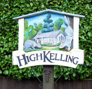
This cache belongs to the Village Sign Series, a series of caches based on ornate signs that depict the heritage, history and culture of the villages that put them up (generally on the village green!).
The signs can be made of different materials from fibreglass to wood, from forged steel to stone. They can depict anything from local industry to historical events. The tradition probably started in Norfolk or Suffolk and has now spread across most of the country so we thought we would base a series on them!
|
More information, bookmarks and statistics can be found at the Village Signs Website
If anybody would like to expand the Village Sign Series, please do.
I would ask that you request a number for your cache first at www.villagesignseries.co.uk
so we can keep track of the Village Sign numbers and names to avoid duplication.
High Kelling is a village and civil parish in the north of the English county of Norfolk. The village is located on the A148 road which links Cromer to King's Lynn. The village is 1.7 miles east of the town of Holt, and 7.8 miles west of Cromer. High Kelling is within the area covered by North Norfolk District Council. In the last Census, carried out in 2001, the population of High Kelling was counted as 515.
All Saints Church is a District Church in the Parish of Holt with High Kelling. The building was built in 1924 and was the chapel of Bramblewood Sanatorium which cared for the sufferers of tuberculosis. After the Sanatorium closed in 1955, the residents of High Kelling purchased the Chapel for £500[4] for their place of worship. The Chapel became licensed for worship in 1970 although it had been then in use for 15 years. In 1977 the Chapel became part of the ecclesiastical parish of Holt.
The heritage railway of the North Norfolk Railway known as the "Poppy Line" runs from near-by Sheringham via Weybourne to Holt. Holt station, although in Holt parish, shares a common boundary with High Kelling.
The cache is a short walk from the village sign(which is waypointed) and over the road - so please be careful with geotots. Please do not go climbing all over the sign!
This cache is a 30ml tube