A close look at faults helps geologists to understand how the tectonic plates have moved relative to one another. Types of movement of crustal blocks that can occur along faults during an earthquake:
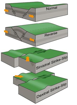
1. Where the crust is being pulled apart, normal faulting occurs, in which the overlying (hanging-wall) block moves down with respect to the lower (foot wall) block.
2. Where the crust is being compressed, reverse faulting occurs, in which the hanging-wall block moves up and over the footwall block – reverse slip on a gently inclined plane is referred to as thrust faulting.
3. Crustal blocks may also move sideways past each other, usually along nearly-vertical faults. This ‘strike-slip’ movement is described as sinistral when the far side moves to the left, and dextral, when the far side moves to the right.
4. An oblique slip involves various combinations of these basic movements, as in the 1855 Wairarapa Fault (new Zealand) rupture, which included both reverse and dextral movement.
Faults can be as short as a few metres and as long as 1000km. The fault rupture from an earthquake isn’t always a straight or continuous line. Sometimes there can be short offsets between parts of the fault, and even major faults can have large bends in them.
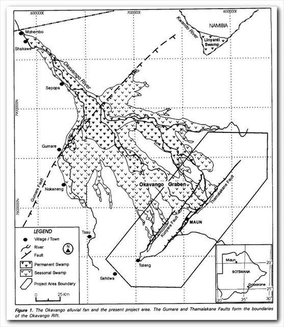
Two parallel faults control the direction in which the Kavango River enters the Kalahari Basin, in an area called the Panhandle. Other faults also direct its exit from the Delta, flowing south into the ocean of sand. As the Okavango flows over the Gomare Fault - a continuation of the Great Rift Valley of east Africa - the slope of the land breaks it up into numerous channels, which fan outwards over the Delta. These are blocked by two southern faults, the Kunyere and the Thalamakane, which redirect the Delta's myriad channels. The Thalamakane Fault acts as a 150-mile-long natural dam: Here the channels abruptly change direction and join to form one river, the Boteti, which flows eastwards through a break in the fault towards the Makgadikgadi Pan. A small channel, the Nghabe River, continues southwest toward Lake Ngami, serving as both inlet and outlet depending on the strength and direction of the annual floods.
The geology of the Okavango is still inherently unstable, as the faults continue to move and earth tremors occur.
Interior drainage systems occur typically in arid areas where water evaporates to leave an accumulation of salts as a saline pan, as in Makgadikgadi and Lake Ngami. The Okavango is unique in that it forms a freshwater Delta, simply because it has several outlets. Even though their outflow comprises only three percent of the Okavango's inflow, this is enough to carry away most of the salts and keep the Delta's waters fresh. In fact there are two groups of outlets: west to Lake Ngami, and south and east to the Makgadikgadi Pan via the Boteti River.
QUESTIONS:
1. According to the map which fault line runs in the area of ground zero?
2. Considering the different types of fault lines as described in the passage, which one do you think played a role in forming the the Delta?
3. Standing at the given co-ordinates what plants, which forms an integral part of the delta system, are growing on the islands directly opposite GZ?
4. Post a picture of you and/or your GPS at the given co-ordinates. (Optional).
5. Describe the surface that you are standing on at GZ. (Please be careful not to post any pictures of this here).
REFERENCES:
www.gns.cri.nz
Fault system at the southeastern boundary of the Okavango Rift, Botswana by MP Modisi, Department of Geology, University of Botswana

NOTE: You will need a 4x4 and some off road driving skills to get to the location = terrain difficulty 4