

Ancaramitos da Ponta do Arnel
[S. Miguel – Açores]
EARTHCACHE
PORTUGUÊS

“O Nordeste é a parte mais antiga da ilha. Seus vulcões emergiram há 4,1 milhões de anos”.
A DÈCIMA ILHA
(O Município do Nordeste)
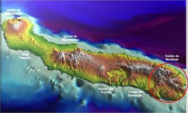
O Nordeste é sede de freguesia com a categoria de vila e sede de um município no mesmo nome. Situa-se no nordeste da Ilha de São Miguel. Têm uma área total de 101,51 Km2 e uma população residente de 4 920 habitantes (Censos 2011). O município é limitado a sul pelo município da Povoação, a oeste pela Ribeira Grande, e a norte e este, pelo oceano Atlântico. Em termos paisagísticos, é a região melhor preservada ambientalmente. Sucedem-se lombas, planaltos, altas montanhas, profundos desfiladeiros onde correm ribeiras caudalosas e as pontas de terra. Na Serra da Tronqueira, temos o Pico da Vara - a mais alta montanha da ilha, com 1 105 metros.
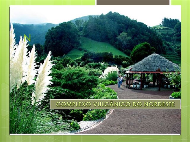
Complexo Vulcânico do Nordeste
O Complexo Vulcânico do Nordeste compreende os produtos vulcânicos mais antigos da ilha de S. Miguel, gerados no decurso de atividade vulcânica essencialmente efusiva, fissural. É constituído por espessas sequências de escoadas lávicas predominantemente basálticas (s.l.) atingem mais de 1.100 metros de espessura, onde ocorrem alguns termos com composição traquítica e depósitos de escórias intercalados. Neste complexo foram identificadas quatro formações resultantes de vulcanismo subaéreo designadas, da mais antiga para a mais recente, basaltos Inferiores, Ancaramitos, Basaltos Superiores e traquibasaltos e tristanitos. Esta sequência apresenta no seu topo produtos vulcânicos gerados por vulcanismo explosivo com origem nos vulcões ativos situados a Oeste. A idade deste complexo varia dos 0.95 - 4.01 M.a.
Ancaramito
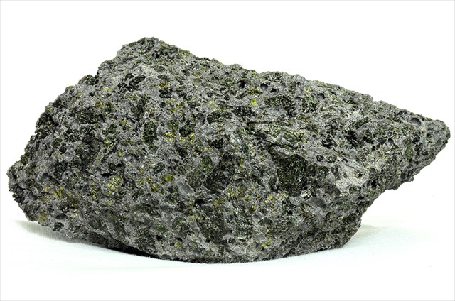
Um ancaramito é um basalto rico em piroxenas ou basanito em que a componente piroxénica é consideravelmente mais abundante do que olivina. É o equivalente alcalino, rico em piroxena, de um picrito. Ancaramitos podem formar como acumulados durante a cristalização a altas temperaturas da clinopiroxena. Podem ainda evoluir por fusão parcial de um werlito mantélico rico em piroxena.
.
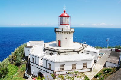
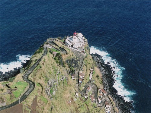
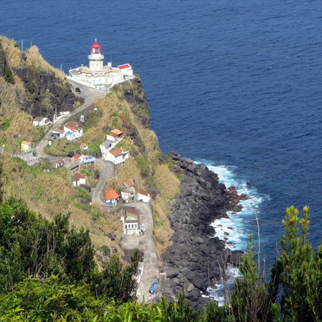
Farol da Ponta do Arnel
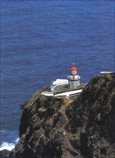
Situado na ponta nordeste da ilha de São Miguel, a que chamam Ponta do Arnel, este pitoresco farol oferece uma vista deslumbrante sobre o Atlântico. Com uma torre prismática branca de 15 metros, este é o farol mais antigo dos Açores. A sua construção começou em 1876. Hoje, ainda pode visitar os edifícios que durante anos serviram de alojamento aos faroleiros.
Segundo Fernandez (1980) na Ponta do Arnel; onde está localizado o farol, afloram ancamaritos. Aqui, estas rochas consistem em 30 a 50% de fenocristais compostas por piroxenas zonadas (núcleos de diópsido com auréolas de titanoaugite.
PARA REALIZAR E REGISTAR ESTA EARTHCACHE:
PERGUNTAS:
Para “encontrar/registar” esta cache deverá: provar que esteve no local e responder às seguintes questões, enviando um email (num prazo de sete dias do seu registo, somente para o email constante do nosso perfil e com o seu texto em português ou em inglês), com as respostas para o nosso perfil:
1. A partir da descrição desta cache e dos teus conhecimentos, responde às seguintes questões:
a) O vulcanismo que deu origem a esta parte da ilha, data de à quantos anos?
b) Como é classificada a atividade vulcânica deste aparelho?
c) Qual é a predominância das escoadas lávicas do complexo vulcânico do Nordeste?
d) Quais as formações identificadas, resultantes do vulcanismo subaéreo deste complexo?
e) Explique, por palavras suas, o que é um ancaramito.
2. Observando a zona do GZ (Farol do Arnel) responde às seguintes questões:
a) De que cor são as rochas no GZ?
b) Conseguem-se distinguir fenocristais nos ancamaritos?
(isto são cristais maiores englobados numa matrix mais fina)?
c) No caso de serem visíveis cristais nas rochas existentes na zona do GZ, de que cor são? Qual o seu diâmetro? São de forma regular ou irregular?
3. Observando a zona do GZ, responde às seguintes questões:
a) Na fachada do farol, quando janelas em forma de cruz, existem?
b) Na curva, em frente ao GZ, existe uma rocha com uma inscrição “disparatada”! O que diz?
4. TAREFA OBRIGATÓRIA:Deverá tirar uma foto sua, onde você apareça (ou com um papel/placa onde conste o seu nickname e a data da visita) e que comprove a sua presença no GZ desta EC - NÃO METASPOILERS. Esta foto deverá ser colocada no seu registo ou enviada por email ou sistema de mensagens de Geocaching, para o owner!

AGRADECIMENTOS:
Agradecemos a especial colaboração do amigo geocacher Daniel de Oliveira e do
Professor Doutor Victor-Hugo Forjaz - Vulcanólogo de Engenharia, Jubilado
e do Observatório Vulcanológico e Geotérmico dos Açores (OGVA).

Ankaramites of “Ponta do Arnel”
[S. Miguel - Azores]
ENGLISH

EARTHCACHE
“The Northeast (“Nordeste”)is the oldest part of the island. Volcanoes emerged there 4.1 million years ago”.
THE TENTH ISLAND
(The Northeast County)
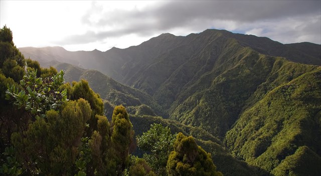
The Northeast parish council with the title of town and seat of the municipality in the same name. It is located in the northeast of Sao Miguel Island. Has a total area of 101.51 km2 and a resident population of 4920 inhabitants (2011 Census). The municipality is bordered to the south by the municipality of the Village, the west by the Ribeira Grande, and the north and east by the Atlantic Ocean. In terms of landscape, the region is better environmentally preserved. Up successive bumps, plateaus, high mountains, deep gorges where creeks run through and headlands. In the "Serra da Tronqueira", we have the "Pico da Vara" - the highest mountain of the island with 1105 meters.
Northeast Volcanic Complex
The Northeast Volcanic Complex comprises the oldest volcanic products of the island of São Miguel, generated in the course of volcanic activity primarily effusive, fissure. It consists of thick sequences of basaltic lava flows predominantly (sl) reaching more than 1,100 feet thick, where there are some terms with trachytic composition and interspersed slag deposits. In this complex there have been identified four formations resulting from subaerial volcanism designated from oldest to the newest, Lower basalts, Ankaramites, superior basalts and trachybasalts and tristanites. This sequence shows at the top volcanic products generated by explosive volcanism emanating from the active volcanoes located west. The age of this complex ranges from 0.95 to 1.4 M. A.
Ankaramite
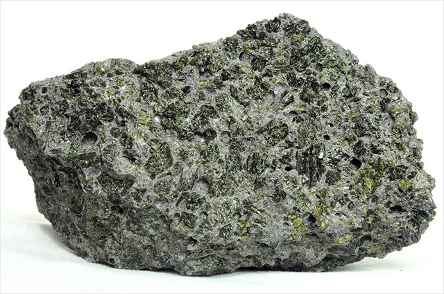
An ankaramite is a pyroxene-rich basalt or basanite in which pyroxene is considerably more abundant than olivine. It is the pyroxene-rich alkaline equivalent of a picrite. Ankaramites may form as cumulates during high temperature clinopyroxene crystallisation, they might also evolve by partial melting of pyroxene-rich mantle wehrlite. Ankaramite is found in ocean islands and island arcs.
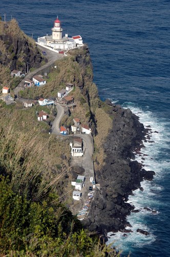
Lighthouse of Ponta do Arnel
Situated on the northeastern tip of the island of São Miguel, which is called "Ponta do Arnel", this picturesque lighthouse offers stunning views of the Atlantic. With a white prismatic tower of 15 meters, this is the oldest lighthouse in the Azores. Its construction began in 1876. Today, you can still visit the building that for years served as a shelter for lighthouse keepers.
According to Fernandez (1980) in Ponta do Arnel; where the lighthouse is located there is a outcrop of ankamarites. Here, these rocks consisting of 30 to 50% pyroxene phenocrysts composed of zoned (diopside cores with titanoaugite halos).

TO PERFORM AND LOG THIS EarthCache:
QUESTIONS:
To "find / register" this cache you must: prove that you visited the site and answer the following questions by sending an
(within seven days of registration, only for the constant email our profile and your text in Portuguese or in English),
the answers to our profile:
1. From the description of this cache and your knowledge, answer the
following questions:
a) For how many years does the volcanism which led to this part of the island, date to?
b) How isthe volcanic activity of this unitclassified ?
c) What is the predominance of volcaniclava flows in the
Northeast complex?
d) What are the identified formations, resulting from subaerial volcanism of this complex?
e) Explain, in your words, what is an ankaramite.
2. Observing the area of GZ (Lighthouse Arnel) answer the following
questions:
a) What color are the rocks in GZ?
b) Can there be distinguished phenocrysts in ankamarites?
(That are encompassed within a larger crystals finer matrix)?
c) In cases of visible crystals in the rocks in the area of GZ, what color are they? What is the diameter? Are they regular or irregular?
3. Observing the area of GZ, answer the following questions:
a) In front of the lighthouse, how many windows in form of a cross are there?
b) In the curve in front of the GZ, there is a rock with a "silly" inscription! What does it say?
4.
TASK (not optional): You must take a picture of yourself, where do you show up, (or with a paper / plaque with your geocaching nickname and the date of the visit) and that proves your presence in the GZ of this EC - no spoilers please. This photo must be placed in your log or sent by email or Geocaching messaging system, to the owner!
THANKS:
We appreciate the special collaboration of the geocacher friend Daniel de Oliveira and
Professor Victor-Hugo Forjaz - volcanologist Engineering, Emeritus
and the Volcanological and Geothermal Observatory of the Azores (OGVA).