OS DOMOS E A TARTARUGA
[S. Miguel – Açores]

EARTHCACHE

PORTUGUÊS

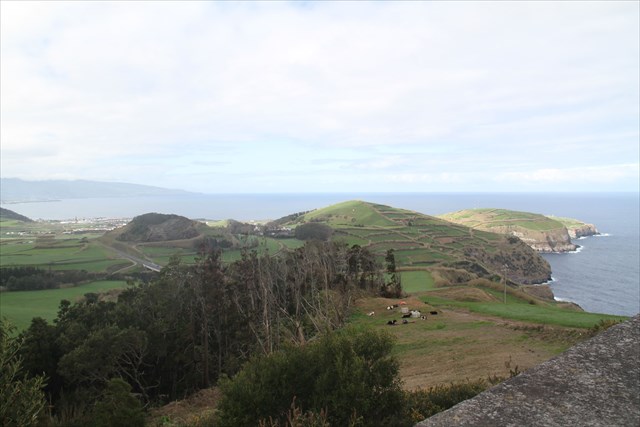
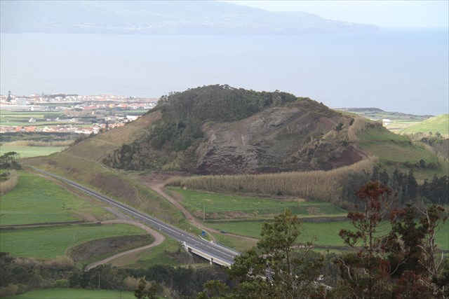
Miradouro da Coroa da Mata
Miradouro situado no concelho de Ribeira Grande, na freguesia da Ribeirinha Seguindo da ER1-1 no sentido da Ribeira Grande para o Nordeste, após passar o cruzamento para as Lombadas e para a Ribeirinha surge à nossa direita uma estrada (a antiga ER 1-1). Após ter percorrido cerca de 4 km este miradouro surge à nossa esquerda. Também se pode aceder a este miradouro entrando na antiga ER 1-1 no cruzamento do Miradouro de Santa Iria. Situa-se a uma altitude de 250 metros.
A GÉNESE…
“Formação da Coroa da Mata (18 600±300 anos B.P. - Moore & Rubin, 1991). A Formação da Coroa da Mata, integrada na Sequência do Flanco Norte, terá sido responsável pela construção do cone de pedra pomes, bem como, na fase final da erupção, do domo traquítico da Coroa da Mata. Esta formação consiste num depósito espesso de pedra pomes de queda muito grosseira, muito rica em cristais de feldspato e anfíbola, com blocos que chegam a atingir 30 cm, rico em líticos com dimensões muitas vezes superiores a 50 cm, e que apresenta alternância de níveis muito grosseiros com níveis mais finos de cinzas, e o topo alterado em paleosolo”.
DOMOS
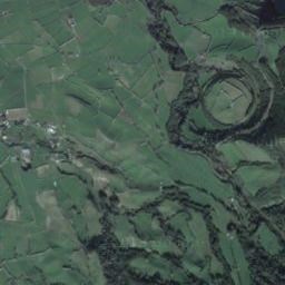
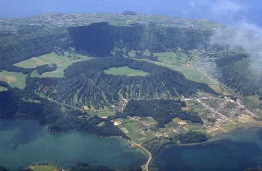
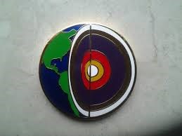
Um domo, em geologia, é uma estrutura de deformação consistindo de anticlinais com inclinações simétricas. O seu contorno geral numa carta geológica é circular ou oval. Os estratos num domo foram erguidos, e se o topo do domo for removido pela erosão, o resultado é uma série de estratos concêntricos que são progressivamente mais antigos quanto mais nos aproximamos do centro do domo, com as rochas mais antigas expostas no centro. Muitos domos geológicos são demasiado grandes para poderem ser apreciados à superfície, sendo aparentes apenas em mapas
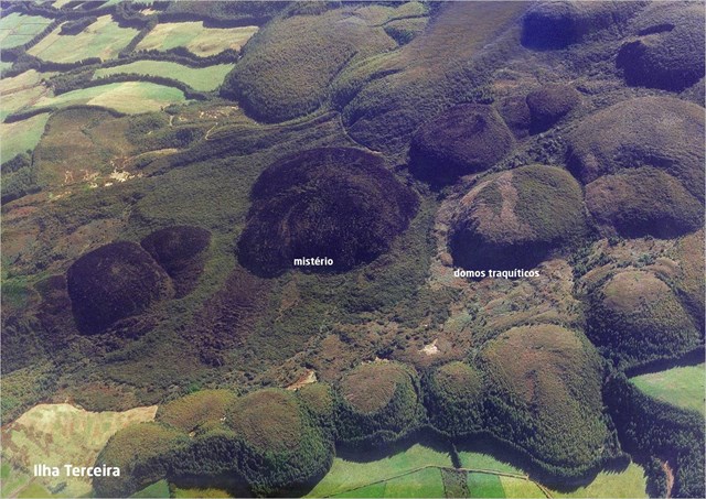
Domos Traquíticos
Formam-se quando a lava é muito viscosa e tem dificuldade em fluir. Tende então a acumular-se diretamente sobre a conduta ou a abertura emissora, originando vertentes muito declivosas. Estas estruturas evidenciam frequentemente uma estrutura rochosa interna segundo camadas concêntricas e níveis mais externos compostos por material muito fragmentado.
Domo de lava
Domo de lava (domo vulcânico ou, por vezes, doma) é a designação dada em geomorfologia e em vulcanologia às formações geológicas formadas pela erupção de lavas muito viscosas, em geral de natureza andesítica, traquítica, dacíticaou riolítica. Os domos são montículos, frequentemente de configuração aproximadamente circular, originados pela erupção lenta de lava rica em sílica, em geral associada a vulcanismo secundário, cuja viscosidade elevada impede o seu normal escoamento pelos flancos do vulcão, obstruindo assim o ponto de emissão da lava.

Origem e características
Um domo vulcânico forma-se em resultado da acumulação de lavas cuja viscosidade, ou aderência, não permite um fluxo com velocidade suficiente para que o material lávico se afaste do ponto de emissão antes de solidificar. Em consequência desta incapacidade de drenagem, forma-se uma estrutura rochosa cupuliforme, o domo, diretamente assente sobre a estrutura emissora, em muitos casos, penetrando e deformando as formações geológicas encaixantes. A principal causa da elevada viscosidade é a riqueza em sílica do material emitido, em geral lavas que por arrefecimento originam rochas andesíticas, traquíticas, dacíticasou riolíticas.
Nessas circunstâncias, a lava emitida pelo vulcão deixa de fluir, ou flui insuficientemente, formando uma cúpula em cima da abertura vulcânica. Esta massa pode assumir diferentes formas, mas geralmente assemelha-se a uma cúpula domiforme, daí o seu nome, medindo em geral de alguns metros até várias centenas de metros de altura. Estes domos podem formar-se no topo de um vulcão, nos seus flancos ou de forma isolada, podendo constituir parte importante, ou mesmo a totalidade, do edifício vulcânico.
Quando a massa de lava estruída não é suficiente para diminuir a pressão na câmara magmática, particularmente em magmas ricos em gases, a obstrução pode levar ao aumento da pressão no interior da estrutura e à criação de condições de explosividade. Devido a esta possibilidade de acumulação de pressão, particularmente quando na presença de gases, os domos podem sofrer ao longo da sua história erupções explosivas que podem produzir plumas vulcânicas de cinzas e gases ou, quando as condições o permitam, a formação de nuvens ardentes.
Uma nuvem ardente forma-se quando um domo de lava colapsa na fase em que ainda estão presentes quantidades apreciáveis de rocha fundida e gases, o que produz um fluxo piroclástico a elevada temperatura, uma das formas mais letais de atividade vulcânica. Outros perigos relacionados com os domos de lava são a formação de laharsiniciados por fluxos piroclásticos nas proximidades de zonas de acumulação de neve ou gelo ou na presença de grandes massas de material geológico saturado em água.
Os domos, especialmente os que alcançam alturas de várias centenas de metros, podem crescer lentamente e de forma contínua durante meses ou mesmo anos. Os flancos destes grandes domos de lava são estruturas formadas por troços instáveis de rocha, em geral marcados por grandes movimentos de massa.
Os domos podem formar-se no interior do edifício vulcânico pela intrusão de lavas viscosas que não chegam a emergir na superfície. Nesse caso, as rochas formadas pelo arrefecimento in loco podem posteriormente aflorar em resultado da atividade erosiva devido à maior resistência à meteorização dos materiais que os constituem, formando então agulhas rochosas que se destacam na paisagem.
Os domos de lava são um dos principais traços dos estratovulcõesde todo o mundo, especialmente os situados ao longo das margens subductivasdas placas tectónicas, tendo como rochas mais frequentes nas cúpulas vulcânicas o andesito e o dacito. No processo de subducção as rochas sedimentares são empurradas para zonas profundas sob a margem continental onde são derretidas, formando um magma rico em gás que sobe na crusta e preenche câmaras magmáticas com uma magma secundário, muito viscoso e rico em gás. Estes magmas podem permanecer por longos períodos nas áreas superiores da crusta sem provocarem uma erupção, num processo de dormência que é em geral quebrado pela entrada na câmara de magma basáltico, fluido e muito quente, oriundo das regiões profundas do manto. Com a entrada deste magma, cuja fluidez e temperatura permite que penetre profundamente na massa magmática já contida na câmara, ocorre o chamado "efeito de mistura de magma", o qual resulta no aquecimento do magma secundário, provocando a sua fusão e o consequente processo físico-químico de reversão do processo de cristalização. Deste processo resulta a formação de um magma relativamente frio (de 800 °C a 980 °C), saturada em sílica e em gases, onde se desenvolvem pressões extremamente elevadas. Estas pressões forçam a subida do material através das zonas de fratura das rochas encaixantes, que sofrem no processo grandes deformações. Quando este material atinge a superfície forma lava muito viscosas, incapazes de fluir, que se acumulam em domos sobre o ponto de extrusão.
Entre os domos de lava mais ativos do mundo incluem-se os localizados no Monte Merapi, na zona central de Java na Indonésia, Soufriere Hills em Montserrat e o Monte Santa Helena no Estado de Washington. Lassen Peak, no norte da Califórnia, é um dos maiores domos de lava do mundo, conhecido por ser o único vulcão da cordilheira Cascade, para além do Monte Santa Helena, que teve atividade eruptiva no século XX (esteve ativo no período 1914–1921).
PARA REALIZAR E REGISTAR ESTA EARTHCACHE:
Material recomendado: bússola com “mira” e binóculos.
PERGUNTAS:
Para “encontrar/registar” esta cache deverá: provar que esteve no local e responder às seguintes questões, enviando um email/mensagem de Geocaching, com as respostas, em português ou em inglês, para o nosso perfil.
Só depois, de enviar as respostas, e conforme as “guidelines” para as Earthcaches, deverá efetuar o seu registo!
Serão removidos todos os registos que não obedeçam a estes requisitos.
1. A partir da descrição desta earthcache, responde às questões:
a) Explica, por palavras tuas, o que é um domo.
b) Classifica o domo da Coroa da Mata
c) As lavas que dão origem a um domo são pouco ou muito viscosas?
d) A baixa ou alta viscosidade da lava que dá origem aos domos, deve-se a quê?
2. A partir do GZ e com o auxílio duma bússola (com mira) e, eventualmente, de uns binóculos, responde às seguintes questões:
a) Identifica Na direção do farol do Cintrão (onde se situa a conhecida “Tartaruga”) e entre os azimutes 310º e 330º, quantos domos são visíveis?
b) O que se separa, do ponto de vista geológico, as várias “estruturas” existentes no azimute 330º?
c) No azimute 240º é visível um domo (logo a seguir à via rápida). O que existe neste domo? É constituída por que materiais?
d) O que vê no azimute 200º, a cerca de 300 metros?
e) Quantos domos são visíveis a partir do GZ?
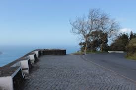
f) No miradouro onde se situa o GZ, existem vários bancos! Quantos são e qual o “tipo” de pedra existente no muro que limita este miradouro?
3.
TAREFA OBRIGATÓRIA:Deverá tirar uma foto sua, onde você apareça (ou com um papel/placa onde conste o seu nickname e a data da visita) e que comprove a sua presença no GZ desta EC - NÃO METASPOILERS. Esta foto deverá ser colocada no seu registo ou enviada por email ou sistema de mensagens de Geocaching, para o owner!
Não responderemos ao seu contato, a não ser que haja algum “problema” com as suas respostas ou registo.


Esta earthache foi produzida durante o AÇORES GeoEarth 2015.
AGRADECIMENTOS:
Agradecemos a especial colaboração do amigo geocacher Daniel Oliveira, bem como do
Professor Doutor Victor-Hugo Forjaz - Vulcanólogo de Engenharia, Jubilado
e do Observatório Vulcanológico e Geotérmico dos Açores (OGVA).

“OS DOMOS E A TARTARUGA”
THE DOMES AND TURTLE
[S. Miguel - Azores]
ENGLISH

Forest Crown (Coroa da Mata) Viewpoint
Viewpoint located in the municipality of Ribeira Grande, in the village of Riverside Following the ER1-1 towards Ribeira Grande to the Northeast, after the crossroads to the Lombadas and the riverfront comes to our right a road (the old ER 1-1 ). After approximately 4 km this viewpoint comes to our left. You can also access this viewpoint into the old ER 1-1 at the intersection of Santa Iria viewpoint. It is located at an altitude of 250 meters.
The GÉNESE …
"Training of Forest Crown (18,600 ± 300 years BP - Moore & Rubin, 1991). Formation of the Crown Forest, part of the North Flank of the sequence, have been responsible for building the cone of pumice stone, and in the final phase of the eruption, the traquítico dome of the Forest Crown. This training consists of a thick deposit of pumice stone very rough fall, very rich in feldspar and amphibole crystals, with blocks that reach 30 cm, rich in lithic with dimensions often exceeding 50 cm, and that presents levels of alternation very coarse with finer shades of gray, and the top amended paleosolo ".
DOMES
A dome, in geology, is a deformation structure consisting of anticlines with symmetrical slopes. The general outline a geological map is circular or oval. The strata in a dome were built, and the top of the dome is removed by erosion, the result is a series of concentric layers that are progressively older the closer we get to the center of the dome, with the oldest rocks exposed in the center. Many geological domes are too big to be assessed on the surface, being apparent only on maps.
Trachytic domes
Are formed when lava is very viscous and has difficulty flowing. Then tends to accumulate directly on the conduct or the station opening, resulting in very steep slopes. These structures often show a second internal rock structure concentric layers and external levels composed of highly fragmented material.
Lava dome
Lava dome (volcanic dome or sometimes doma) is the name given in geomorphology and volcanology to geological formations formed by the eruption of highly viscous lavas, generally andesitic nature, trachytic, dacitic or riolítica. The domes are mounds, often approximately circular configuration, originated by the slow eruption of lava rich in silica, usually associated with secondary volcanism, whose high viscosity prevents the normal flow down the flanks of the volcano, thus blocking the lava emission point.
Origin and characteristics
A volcanic dome formed as a result of lava accumulation whose viscosity, or grip, prevents a flow fast enough to the lava material away from the emission point before solidifying. As a result of this inability to drain, forms a cupuliforme rock structure, the dome station directly based on the structure, in many cases, penetrating and deforming enclosing geological formations. The main cause of high viscosity is emitted from the silica rich material, generally by cooling to originate lava rocks andesitic, traquíticas, or dacíticas rhyolitic.
In these circumstances, the lava emitted by the volcano stops flowing, or insufficiently flows, forming a dome over the volcanic vent. The mass may take different forms, but generally resembles a domiforme dome, hence its name, measuring generally from a few meters to several hundred meters high. These domes may be formed on top of a volcano, on their flanks or in isolation, can be an important part, if not all, of the volcanic edifice.
When mass estruída lava is not enough to lower the pressure in the magma chamber, particularly in magmas rich in gas, the obstruction may lead to increased pressure inside the structure and the creation of explosive conditions. Because of this possibility of pressure build-up, particularly in the presence of gases, the domes can suffer throughout their history explosive eruptions that can produce volcanic ash plumes and gases or, when conditions permit, the formation of burning clouds.
A burning cloud formed when a lava dome collapses at the stage are still present in appreciable amounts molten rock and gases, which produces a pyroclastic flow at elevated temperature, one of the most lethal form of volcanic activity. Other hazards related to lava domes are the formation of lahars started by pyroclastic flows nearby snow accumulation zones or ice or in the presence of large masses of geological material saturated with water.
The domes, especially those that reach heights of several hundred meters, can grow slowly and continuously for months or even years. The flanks of these great lava domes are structures formed by unstable rock sections, usually marked by large mass movements.
The domes may be formed inside the volcanic edifice by the intrusion of viscous lava that fail to emerge on the surface. In this case, the rocks formed by cooling spot may subsequently emerge as a result of erosive activity due to increased resistance to weathering of the materials comprising the then forming rocky needles that stand out in the landscape.
The lava domes are one of the main features of stratovolcanoes around the world, especially those along the subductivas margins of tectonic plates, with the most common rocks in the volcanic domes andesite and dacite the. In subduction process sedimentary rocks are pushed deep zones in the continental margin where they are melted, forming a gas-rich magma that rises in the crust and magma chambers fill with a secondary magma, very viscous and rich in gas. These magmas may remain for long periods in the upper areas of the crust without causing a rash, numbness in a process that is usually broken by the entry in the basaltic magma chamber, fluid and very hot, arising from deep regions of the mantle. With the entry of this magma, whose flow and temperature allows it to penetrate deep in the magma mass already contained in the chamber, is called "magma mixing effect", which results in the secondary magma heating, causing it to melt and the consequent process physico-chemical reversal of the crystallization process. This process results in the formation of a magma relatively cool (800 ° C to 980 ° C) saturated with silica and gases, which develop extremely high pressures. These pressures force the rise of the material through the fracture zones of host rocks, suffering in the process large deformations. When this material reaches the surface of highly viscous wash medium, incapable of flowing, which accumulate in domes on the point of extrusion.
Among the most active lava domes in the world include those located in the Mount Merapi in central Java in Indonesia, Soufriere Hills in Montserrat and Mount St. Helens in Washington State. Lassen Peak in northern California, is one of the largest lava domes in the world, known for being the only volcano in the Cascade mountain range, in addition to the Mount St. Helens, which had eruptive activity in the twentieth century (was active in period 1914-1921).

TO PERFORM AND LOG THIS EarthCache:
Recommended material: compass with "sight" and binoculars.
QUESTIONS:
To "find / register" this cache must: prove that visited the site and answer the following questions by sending an email / message Geocaching, with answers (in Portuguese or in English, only) to our profile.
Only later, sending the answers, and as the "guidelines" for EarthCaches should make your registration! They will be removed from all records that do not meet these requirements.
1. From the description of this EarthCache, answers the questions:
a) Explain, in your words, which is a dome.
b) Sorts the dome of the Crown Forest
c) lava which give rise to a dome are poorly or highly viscous?
d) Low or high viscosity lava that gives rise to domes, is due to what?
2. From the GZ and with the aid of a compass (with sights) and, possibly, binoculars, answer the following questions:
a) Identify the direction of Cintrão lighthouse (which it has known "Turtle") and azimuths between 310 and 330, how many domes are visible?
b) What separates, from the geological point of view, several "structures" within the azimuth 330?
c) azimuth 240 is visible a dome (just after the highway). What exists in this dome? It consists of that material?
d) What you see on azimuth 200 °, about 300 meters?
e) How many domes are visible from the GZ?
f) In the gazebo where lies the GZ, there are several banks! How many and what "type" of existing stone in the wall that limits this viewpoint?
3.
TASK (not optional): You must take a picture of yourself, where do you show up, (or with a paper / plaque with your geocaching nickname and the date of the visit) and that proves your presence in the GZ of this EC - no spoilers please. This photo must be placed in your log or sent by email or Geocaching messaging system, to the owner!
We do not respond to your touch, unless there is a "problem" with their answers or register.
This earthache was produced during the Azores GeoEarth 2015.
THANKS:
We appreciate the special collaboration of the geocacher friend Daniel Oliveira and the
Professor Victor-Hugo Forjaz - volcanologist Engineering, Emeritus
and the Volcanological and Geothermal Observatory of the Azores (OGVA).