
|
 |

|
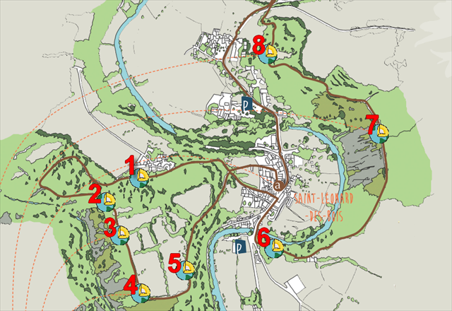
Cette série de 8 earthcachesest située sur le sentier intitulé "Histoires Géologiques". Chaque earthcache se trouve à l'emplacement d'un panneau informatif. Ce parcours vous permet de retracer 600 millions d'annéesd'histoire qui ont formé les roches et façonné le paysage. Le circuit, long de 10 kilomètres(3 heures environ), avec de forts dénivelés, est balisé et fléché en brun.
ATTENTION! Le parcours est fléché dans un seul sens, à l'inverse des aiguilles d'une montre. Les parkings et le point de départ du sentier sont indiqués en waypoints additionnels.
|
This series of 8 Earthcaches is on the trail entitled "Geological Stories". Each earthcache is located in the vicinity of an information board. This tour allows you to trace 600 million years of a history of geological events that formed the rocks and shaped the landscape. The circuit, 10 kilometers long (about 3 hours), with steep climbs, is marked and signposted in brown.
WATCH OUT! The tour is signposted in one direction, anticlockwise. Car parks and the starting point of the trail are in additional waypoints.
|
 |
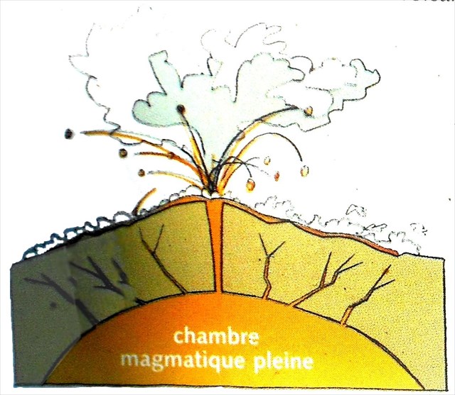
Le volcanismeest le processus par lequel le magma, roche en fusion à l’intérieur de la terre, traverse l’écorce terrestre pour arriver en surface. Les matériaux volcaniques varient en fonction des propriétés du magma dont ils sont issus. Des différences de composition chimique, de teneur en gaz, de température affectent la façon dont le magma arrive en surface, donc le type de volcan et de roches volcaniques qu’il produit.
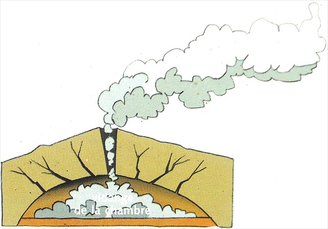
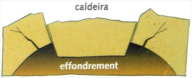
Le magma quitte les chambres magmatiques soit par des fractures de la croûte, soit en faisant fondre les roches environnantes. Lorsque la chambre magmatique se vide, la roche n’étant plus soutenue, le sommet du volcan s’effondre formant une dépression généralement circulaire appelée caldeira (chaudron).
Les ignimbrites (de ignis, feu et imber, pluie) se forment lors d’éruptions de volcans à base très large, du même type que le Kilimandjaro, appelés stratovolcans. La destruction de la ville romaine de Pompéi est due à une éruption de type ignimbrite. Extrêmement violentes, ces éruptions se traduisent par l’émission de nuées ardentes ou coulées pyroclastiques (de puros, feu et klastos, éclats) accompagnées de l’expulsion d’un volume considérable de cendres sous forme de colonnes hautes de plusieurs km, et de la formation de laves : rhyolithes, andésites – qui leur sont toujours étroitement associées.
Il y a 520Ma, l’extrémité du Massif armoricain connait une intense activité volcanique localisée dans un vaste fossé, long de 75 et large de 50 km, appelé graben Normandie-Maine. Nous sommes à la lisière de la caldeira d’Assé-le-Boisne dont le diamètre avoisine 20 km. A l’intérieur de cette cuvette s’accumulent d’épaisses nappes d’ignimbrites tandis qu’à l’extérieur s’échappent des nuées ardentes (coulées pyroclastiques) accompagnées de laves pâteuses et d’énormes coulées de boue.
|
|
   |
|
Volcanic eruptions are a process where magma (molten rock deep within the earth), passes through the earth’s crust and arrives on its surface. Volcanic material itself varies depending on the type of magma. There are differences in chemical composition, gas content, and temperature that affect the way in which the magma arrives on the surface, and thus the type of volcano and volcanic ash and rock that it produces.
The magma or molten rock leaves the chambers either through fissures in the earth's crust, or through melting the surrounding rock. As the magma chamber empties, the rock above it is no longer supported and the roof of the volcano collapses to form a depression know as the crater which is usually circular.
Ignimbrites (from the Greek ignis meaning fire and imber meaning rain) are deposited by a volcanic eruption and spread over a wide area such as at Mount Kilimanjaro, they are called stratovulcanoes. The destruction of the Roman town of Pompeii was due to an ignimbrite-type eruption. Extremely violent, these eruptions emit glowing clouds accompanied by a considerable volume of cinders in the form of high columns that rise several kilometers into the air, with a flow of pyroclastic material (from the Greek pyro meaning fire and klastic meaning broken) forming rhyolitic and andesite lava.
Five hundred and twenty million years ago, in the most eastern area of the Armorican Massif, there was intense volcanic activity along in a large ditch, 75 km long and 50 km wide, called the Normandie-Maine Graben. Here, we are at the edge of the Assé-le-Boisne crater, which has a diameter of its approximately 20 km. Insid the crater thick layers of ignimbrites accumulated while outside it glowing clouds escaped (forming pyroclastic flows) accompanied by viscous lava and enormous mud slides.
|
Comment valider votre visite ?
Allez aux coordonnées indiquées au début de ce descriptif. Vous trouverez un panneau d'information. Afin de valider votre visite, vous devez répondre aux questions suivantes :
1) Sur la gauche du panneau, vous trouverez 2 viseurs. Que peut-on voir dans le viseur de gauche ?
2) Sur la gauche du panneau, vous trouverez 2 viseurs. Que peut-on voir dans le viseur de droite ?
3) A quelle période géologique, y-a-t-il eu une explosion de la vie ?
4) OBLIGATOIRE : prenez une photo de vous, de votre GPS ou d’un objet personnel, à joindre avec votre log, avec le dôme d'ignimbrite en arrière-plan. (Guidelines des earthcaches du 10 juin 2019).
Envoyez vos réponses par mail ou messagerie geocaching. Inutile d'attendre ma validation pour logguer un "Found it", mais si vous oubliez de me fournir les réponses, votre log sera supprimé.
|
How to validate your visit !
Go to the coordinates indicated at the top of this page. Here you will find an information board. In order to validate your visit, you have to answer the following questions:
1) On the right of the panel you will find two viewfinders. What can you see in the left viewfinder ?
2) On the right of the panel you will find two viewfinders. What can you see in the right viewfinder ?
3) What are the four kinds of the most prevalents minerals on earth ?
4) MANDATORY : take a picture of yourself, your GPSr or a personal object, to be attached with your log, with the ignimbrite dome in the background. (Earthcaches guidelines of June 10, 2019).
Send me your answers via mail or Geocaching Message Center (e-mail on my profile). You do not need to wait for my validation to log a "Found it" but if you forget to send me your answers, your log will be deleted.
|
|
|