
|
 |

|
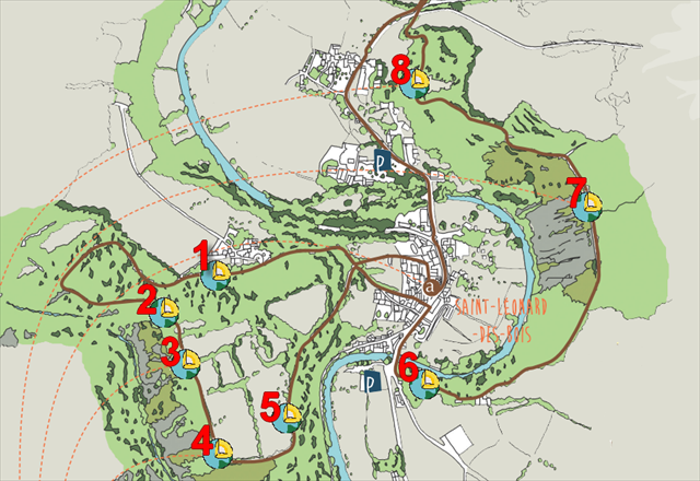
Cette série de 8 earthcachesest située sur le sentier intitulé "Histoires Géologiques". Chaque earthcache se trouve à l'emplacement d'un panneau informatif. Ce parcours vous permet de retracer 600 millions d'annéesd'histoire qui ont formé les roches et façonné le paysage. Le circuit, long de 10 kilomètres(3 heures environ), avec de forts dénivelés, est balisé et fléché en brun.
ATTENTION! Le parcours est fléché dans un seul sens, à l'inverse des aiguilles d'une montre. Les parkings et le point de départ du sentier sont indiqués en waypoints additionnels.
|
This series of 8 Earthcaches is on the trail entitled "Geological Stories". Each earthcache is located in the vicinity of an information board. This tour allows you to trace 600 million years of a history of geological events that formed the rocks and shaped the landscape. The circuit, 10 kilometers long (about 3 hours), with steep climbs, is marked and signposted in brown.
WATCH OUT! The tour is signposted in one direction, anticlockwise. Car parks and the starting point of the trail are in additional waypoints.
|
 |
Roches et minérauxconstituent la croute terrestre. Il existe sur terre plus de deux mille minéraux différents. Les roches sont des combinaisons de minéraux, formées au cours de processus géologiques divers : mouvements des plaques tectoniques, éruptions volcaniques, échanges avec les êtres vivants et l'atmosphère, dépôt et tassement des sédiments ; ces débris minéraux et rocheux arrachés par l'érosion, transportés par l'eau ou le vent, se déposent en couches successives à la surface de la terre ou au fond des mers. Profondément enfouis, ils sont compactés, « lithifiés », formant les roches sédimentaires.
Roche sédimentaire des plus communes, le grès affleure un peu partout à la surface de la Terre. Les grès sont des roches composées de grains de sable cimentés entre eux dont le diamètre n'excède pas 2 mm. Le quartz, à grains arrondis en est le principal constituant.
Le grès armoricain ou quartzite, est une roche sédimentaire. Formé durant l'Ordovicien (-480 millions d’années) le grès armoricain a subi un plissement par la formation de la chaîne hercynienne.
Le grès armoricain, roche très dure est transformée en granulats pour être utilisé pour les moellons et les gravillons, dans la construction de route.
|
|
 |
|
The crust of the earth is made up of rocks and minerals. There are more than two thousand different minerals on earth. Rock is a combination of minerals formed during the course of various geological processes including tectonic plate movements, volcanic eruptions, exchanges between living beings and the atmosphere, and the depositing of sediment and its subsequent compression. This rocky mineral debris is ceaselessly being displaced by erosion, transported by water and becomes deposited in successive layers on earth’s surface or the sea bed. When buried at a great depth, the mineral becomes compacted, or « lithified » thus forming sedimentary rock.
The most common sedimentary rock can be seen almost everywhere on Earth’s surface. Sandstone is a rock made up of grains of sand cemented together, their diameter being no more than 2 millimeters. Quartz, with its rounded grains, is the main constituent.
The Armorican sandstone or quartzite is a sedimentary rock. Formed during the Ordovician (-480 000 000 years ago) Armorican sandstone underwent wrinkling by the formation of the Hercynian chain.
The Armorican sandstone, very hard rock is turned into pellets to be used for rubble and gravel in the road construction. |
Comment valider votre visite ?
Allez aux coordonnées indiquées au début de ce descriptif. Vous trouverez un panneau d'information. Afin de valider votre visite, vous devez répondre aux questions suivantes :
1) Sur la droite du panneau, vous trouverez 2 viseurs. Que peut-on voir dans le viseur de gauche ?
2) Sur la droite du panneau, vous trouverez 2 viseurs. Que peut-on voir dans le viseur de droite ?
3) Quelles sont les 4 sortes de minéraux les plus répandus sur terre ?
4) OBLIGATOIRE : prenez une photo de vous, de votre GPS ou d’un objet personnel, à joindre avec votre log, avec la carrière en arrière-plan.(Guidelines des earthcaches du 10 juin 2019).
Envoyez vos réponses par mail ou messagerie geocaching. Inutile d'attendre ma validation pour logguer un "Found it", mais si vous oubliez de me fournir les réponses, votre log sera supprimé.
|
How to validate your visit !
Go to the coordinates indicated at the top of this page. Here you will find an information board. In order to validate your visit, you have to answer the following questions:
1) On the right of the panel you will find two viewfinders. What can you see in the left viewfinder ?
2) On the right of the panel you will find two viewfinders. What can you see in the right viewfinder ?
3) What are the four kinds of the most prevalents minerals on earth ?
4) MANDATORY : take a picture of yourself, your GPSr or a personal object, to be attached with your log, with the quarry in the background. (Earthcaches guidelines of June 10, 2019).
Send me your answers via mail or Geocaching Message Center (e-mail on my profile). You do not need to wait for my validation to log a "Found it" but if you forget to send me your answers, your log will be deleted.
|
|
|