OS FILÕES DA FAJÃ DAS ACHADAS DA CRUZ
[Madeira]
EARTHCACHE
PORTUGUÊS
FAJÃ DAS ACHADAS DA CRUZ
A freguesia da Feira do Gado
PTMAD0005
A freguesia das Achadas da Cruz localiza-se no extremo noroeste da ilha da Madeira. Entre a Ponta do Pargo e a Ponta do Tristão.
Pertence ao concelho do Porto Moniz. Devido à sua altitude, o povoamento das Achadas da Cruz foi bastante moroso. No entanto, no terceiro quartel do Século XVI foi constituído o primeiro núcleo populacional. A freguesia das Achadas da Cruz viu nascer diversas personalidades que, por diferentes razões, permanecem na memória da freguesia. Entre elas destaca-se o grande benfeitor Manuel de Pontes Câmara, que contribuiu para a construção da primeira capela.
Freguesia pequena, as Achadas da Cruz assentam a as suas atividades económicas na agricultura e na pecuária. Atente-se para a realização anual da tradicional Feira do gado, onde existe um recinto próprio para a realização do evento. Crê-se que a freguesia das Achadas da Cruz acolhe cerca de 220 habitantes. Em relação ao clima, é ameno. No Inverno é um pouco chuvoso, mas sempre com temperaturas médias a rondar os 17ºC.
![*]() SÍTIO DA “REDE NATURA 2000”
SÍTIO DA “REDE NATURA 2000”
“Todo o património geológico do arquipélago da Madeira e do sub-arquipélago das Selvagens, constituído por todos os recursos naturais, tais como, as «formações rochosas, acumulações sedimentares, formas, paisagens, caracteres paleontológicos ou coleções de objetos geológicos de valor científico, cultural, educativo e de interesse paisagístico, deve ser protegido».
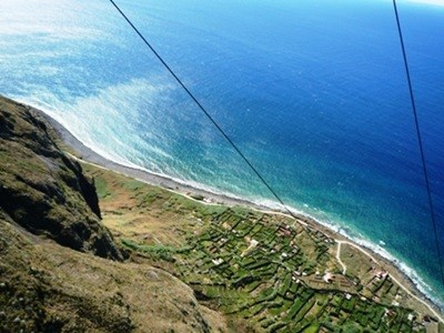
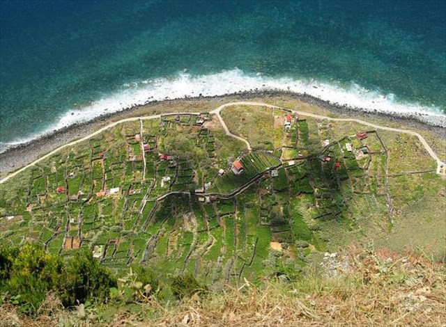
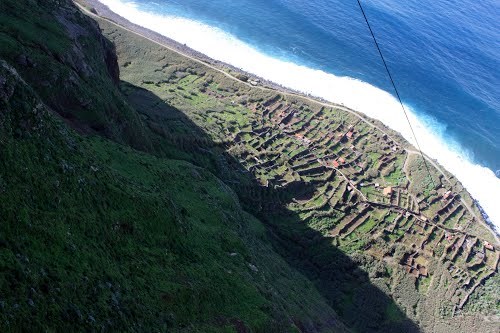
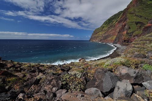
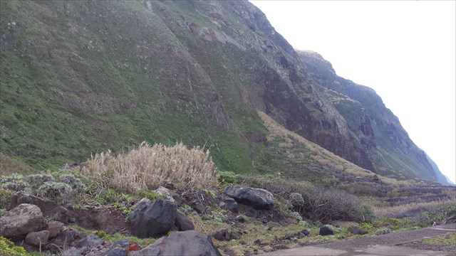
AS FAJÃS
Fajãé um termo de origem obscura que designa umterrenoplano, em geral cultivável, de pequena extensão, situado à beira-mar, formado de materiais desprendidos das arribas ou por deltas lávicos resultantes da penetração nomarde escoadas delava provenientes da vertente.Pode-se definirfajãcomotoda a terra baixa e chãou comopequena extensão de terreno plano, suscetível de cultura, junto a uma rocha, geralmente à beira-mar, formada em regra por materiais desprendidos por quebradas ou acumulados na foz de uma ribeira e assentes quase sempre num banco de lava muito resistente.
A palavrafajãestá expandida em toda aMacaronésialusófona, sendo muito comum nos Açores, onde aparece em quase todas as ilhas, nailha da Madeirae em muitas ilhas deCabo Verde.
Embora o termofajãseja em geral utilizado para designar plataformas costeiras, é por vezes utilizado na toponímia da Macaronésiaem ligação a pequenas zonas planas anichadas junto a montes ou colinas com encostas íngremes. Nesta aceção a palavra confunde-se com o termoachada, também utilizado naMacaronésiapara descrever uma zona aplanada entre montes, em especial as plataformas planálticas suspensas entres os grandes vulcões centrais das ilhas e a costa.
Tipos de fajãs
De acordo com as suas características, origem e localização, as fajãs podem ser classificadas em:
1) Fajãs costeiras– fajãs em contacto direto com o litoral.
Fajãs de delta lávico– fajãs criadas quando as escoadas delavaavançam sobre o mar, provocando o recuo da linha de costa. Estas fajãs, em geral muito resistentes à erosão do mar por serem constituídas por grandes massas rochosas compactas e sem fissuração apreciável, são em geral delimitadas por costas abruptas, angulosas, fortemente recortadas, com grandes calhaus no seu sopé. Os solos, quando não tenha havido recobrimento por materiais de projeção ou derrocadas posteriores, são em geral esqueléticos. À superfície destes deltas podem ocorrer pseudo-crateras ou cones litorais e a erosão da frente da escoada ou uma drenagem posterior conferem-lhe frequentemente um aspeto digitado. São frequentes os arcos rochosos costeiros e as grutas marinhas resultantes da infraescavação pela erosão por ação do mar.
Fajãs de talude (ou fajãs detríticas)– são fajãs criadas pela acumulação de materiais resultantes do desmoronamento das encostas sobranceiras. Estas fajãs tendem a ser mais aplanadas e, por serem constituídas por materiais soltos, facilmente sujeitos ao transporte pelasondas, têm em geral costas de formas suaves e quase retilíneas, com praias de calhau rolado de dimensão variável. Nas costas mais expostas à ondulação, em geral as viradas a norte, formam-se por vezescordões de calhaus roladosque conduzem ao aparecimento de formações lagunares (como acontece naFajã da Caldeira de Santo Cristo). Os solos destas fajãs são em geral muito férteis, embora as mais perigosas, para habitação humana, dada a recorrência dos desmoronamentos. Os grandes terramotos tendem a formar novas fajãs deste tipo, como aconteceu profusamente no grande sismo doMandado de Deus, na metade leste de São Jorge.
2) Fajãs de altitude e pequenasachadas– fajãs encaixadas em encostas longe do mar, em geral pequenos planaltos ou vales aplainados no sopé de montanhas ou de cones vulcânicos.
Fajãs de encosta– plataformas formadas em consequência de quebradas que deixam plataformas de ablação nas encostas. Em geral de pequena extensão, apresentam pouco interesse para uso humano, mas são importantes como biótopospara espécies que exigem boa exposição solar e boa drenagem.
Fajãs de sopé ou pequenasachadas– são plataformas aplanadas existentes no sopé de encostas ou entre cones vulcânicos. O termoachadaresulta do seu interesse como locais privilegiados de cultivo, preferidos para fixação pelos colonizadores quando osachavamno desbravar das ilhas.
A EARTHCACHE:
Existem três formas de alcançar esta cache devidamente assinalados com waypoints:
- Vereda da Ladeira: Terrain and difficulty=4
- Vereda do Calhau das Achadas da Cruz: Terrain and difficulty=4
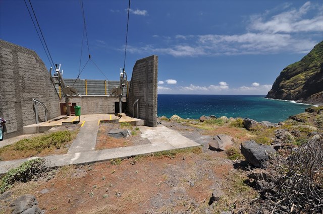
- Teleférico: Terrain and difficulty=2.5
Teleférico Achadas da Cruz
O teleférico das Achadas da Cruz funciona num sistema vaivém e faz a ligação entre as Achadas da Cruz e a Fajã da Quebrada Nova, localizado no Porto Moniz, Ilha da Madeira. Além da função turística e balnear serve, ainda, para facilitar aos agricultores o transporte de colheitas e o acesso às propriedades agrícolas aí existentes. Um moderno e atraente meio de transporte liga Achadas da Cruz ao mar e a locais quase inalcançáveis. Uma forma diferente de descobrir a beleza de Porto Moniz, de uma forma confortável e segura. Entre o verde das serras e o azul do mar destacam-se os passeios a pé pelas muitas levadas e veredas.
Horário de Verão
Horário de Funcionamento:
De 2ª a 6ª:
Manhã: das 08H00 às 09H00
Tarde: das 13H00 às 20H00
Sabado, Domingos e Feriados:
Manhã: das 07H30 às 08H00
Tarde: das 13H00 às 20H00
Horário de Inverno
Horário de Funcionamento:
De 2ª a 6ª:
Manhã: das 08H00 às 09H00
Tarde: das 11H00 às 18H00
Sabado, Domingos e Feriados:
Manhã: das 07H30 às 08H00
Tarde: das 11H00 às 18H00
PARA REALIZAR E REGISTAR ESTA EARTHCACHE:
PERGUNTAS:
Para “encontrar/registar” esta cache deverá: provar que esteve no local e responder às seguintes questões, enviando um email/mensagem de Geocaching, com as respostas, em português ou em inglês, para o nosso perfil.
Só depois, de enviar as respostas, e conforme as “guidelines” para as Earthcaches, deverá efetuar o seu registo!
Serão removidos todos os registos que não obedeçam a estes requisitos.
1. Responde às seguintes questões:
a) Explica, por palavras tuas, o que é uma fajã.
b) Classifica a Fajã das Achadas da Cruz.
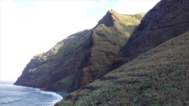
2. A partir do GZ e observando a falésia, é possível observar várias zonas vermelhas!
a) Qual o nome deste material vermelho?
b) Sempre foi vermelho? Porque razão mudou de cor e ficou vermelho?
3. Observando a zona do GZ responde às seguintes questões:
a) Durante o percurso até ao GZ, terás observado algumas máquinas agrícolas abandonadas, bem como o antigo “fio” de carga. Perto do GZ existe um oratório! É dedicado a que Santo?
b) Qual é a altura aproximada, da falésia que se situa junto à Fajã das Achadas da Cruz.
4.
TAREFA OBRIGATÓRIA:Deverá tirar uma foto sua, onde você apareça (ou com um papel/placa onde conste o seu nickname e a data da visita) e que comprove a sua presença no GZ desta EC - NÃO METASPOILERS. Esta foto deverá ser colocada no seu registo ou enviada por email ou sistema de mensagens de Geocaching, para o owner!

Não responderemos ao seu contato, a não ser que haja algum “problema” com as suas respostas ou registo.


AGRADECIMENTOS:
Agradecemos a especial colaboração do amigo geocacher Hugo Pita.
“OS FILÕES DA FAJÃ DAS ACHADAS DA CRUZ”
[Madeira]
ENGLISH

EARTHCACHE
“FAJÃ DAS ACHADAS DA CRUZ”
The parish of Fair Cattle
PTMAD0005
The parish of Achadas da Cruz is located in the extreme northwest of the island of Madeira. Between "Ponta do Pargo" and "Ponta do Tristão" .
It belongs to the municipality of Porto Moniz. Due to its altitude, populating Achadas da Cruz was quite time consuming. However, in the third quarter of the sixteenth century the first population centerwas constituted . The parish of Achadas da Cruz saw the birth of several people who, for various reasons, remain in the memory of the parish. Among them stands out the great benefactor Manuel de Pontes Câmara, which contributed to the construction of the first chapel.
As a small town, Achadas da Cruz is based on their economic activities in agriculture and livestock. Attention is drawn for the annual traditional cattle fair, where there is a proper venue for the event. It is believed that the parish of Achadas da Cruz hosts about 220 inhabitants. The climate is mild. In winter it's a little rainy, but always with average temperatures of around 17 ° C.
![*]() SITE OF: “REDE NATURA 2000”
SITE OF: “REDE NATURA 2000”
"All the geological heritage of the archipelago of Madeira and the Selvagens (Wild) sub-archipelago, consisting of all natural resources, such as the" rock formations, sedimentary accumulations, forms, landscapes, characters or paleontological collections of geological objects of scientific value, cultural, educational and scenic interest, must be protected. "

THE: “FAJÃS”
“Fajã” is an obscure source term for flat terrain generally arable, of small extent, situated by the sea, formed of material detached from cliffs or lava deltas resulting from the penetration in the sea of lava from the slope disposed. You can set fajã as all the low land and tea or as small tract of land plan, susceptible of culture, next to a rock, usually by the sea, formed usually by loosened materials for broken or accumulated at the mouth of a river and based almost always a very tough lava bank.
The word fajã is expanded throughout the Lusophone Macaronesiaand very common in the Azores, where it appears in almost all the islands, the island of Madeiraand in many islands of Cape Verde.
Although the term “fajã” is generally used to designate coastal platforms, is sometimes used in place names in the Macaronesia in connection to small anichadas flat areas along the mountains or hills with steep slopes. In this meaning the word is confused with the term found, also used in Macaronesia to describe a flattened area between hills, especially plateau suspended platforms entres major central volcanoes of the islands and the coast.

Types of “Fajãs”
According to its characteristics, origin and location, the coves can be classified into:
1) Coastal Fajãs- fajãs in direct contact with the coast.
Fajãs of lava delta- fajãs created when lava drained advance of the sea, causing the retreat of the shoreline. These coves in very resistant to erosion by the sea usually are made from large rock masses and compact without appreciable cracking, are generally bounded by abrupt back, angular, heavily cut, with large pebbles in his foot. The soils, when there was no covering for projection of material or subsequent landslides, are generally skeletal. On the surface these deltas may occur pseudo-craters or coastal cones and the front of the erosion of drained or a later drainage often give it a typed aspect. Are frequent coastal rocky arches and sea caves resulting from infraescavação erosion by action of the sea.
Slope Fajãs (or fajãs detrital)- fajãs are created by the accumulation of materials resulting from the collapse of hillsides. These fajãs tend to be flattened, and are constituted by loose material easily subject to transportation waves, have generally smooth back and almost rectilinear shapes with rolled pebble beach variable dimension. In the most exposed back to the waves, in general face north, formed sometimes pebbles rolled seams that are resulting in lagoon formations (as in the Faja Caldeira de Santo Cristo). The soils of these coves are very fertile general, although the most dangerous for human habitation, given the recurrence of landslides. The great earthquakes tend to form new coves such as profusely happened in the great earthquake of Warrant of God, in the eastern half of St. George.
2) Fajãs altitude and small found- fajãs fitted on slopes away from the sea, usually small plateaus or flattened valleys at the foot of mountains or volcanic cones.
Slope of coves- platforms formed as a result of broken leaving ablation platforms on the slopes. Generally of small extent, have little interest for human use, but are important as biotopes for species that require good sun exposure and good drainage.
Foot of coves and small found- are flattened existing platforms in the slopes of the foot or between volcanic cones. The term results found of interest as privileged places of culture, preferred for fixing by settlers when they thought the blaze in the islands.

THE EARTHCACHE:
There are three ways to achieve this properly marked cache with waypoints:
- Vereda Ladeira: Terrain and difficulty = 4
- Vereda do Calhau Achadas da Cruz: Terrain and difficulty = 4
- Cable Car: Terrain and difficulty = 2.5
Cable Car “Achadas da Cruz”
The cable car of the “Achadas da Cruz” works in a shuttle system and connects the Achadas da Cruz and the “Faja da Quebrada Nova”, located in Porto Moniz, Madeira. Besides the tourist and bathing function it also has been built to facilitate farmers transporting crops and accessing to the existing farms there . A modern and attractive mean of transport links Achadas da Cruz to the sea and the almost unreachable places. A different way to discover the beauty of Porto Moniz, a comfortable and safe manner. Among the green hills and the blue sea the many walking pathsstand out.
Daylight Saving Time
Hours:
From 2ª to 6ª:
morning: das 08H00 às 09H00
afternoon: das 13H00 às 20H00
Saturday, Sundays and holidays:
morning: from 07H30 to 08H00
afternoon: from 13H00 to 20H00
Winter Hours
Hours:
From 2ª to 6ª:
morning: from 08H00 to 09H00
afternoon: from 11H00 to 18H00
Saturday, Sundays and holidays:
morning from 07H30 to 08H00
afternoon: from 11H00 to 18H00
TO PERFORM AND LOG THIS EarthCache:
QUESTIONS:
To "find / register" this cache must: prove that visited the site and answer the following questions by sending an email / message Geocaching, with answers (in Portuguese or in English, only) to our profile.
Only later, sending the answers, and as the "guidelines" for EarthCaches should make your registration! They will be removed from all records that do not meet these requirements.
1. Answer the following questions:
a) Explain, in your words, what is a “fajã”.
b) Classify the kind of fajã that "Faja das Achadas da Cruz" is.
2. From the GZ and watching the cliff, you can see several red zones!
a) What is the name of this red stuff?
b)Wwas it always red? Why has the colorchanged to red?
3. Observing the GZ zone answer the following questions:
a) On the way to the GZ, you have observed some abandoned farm machinery, as well as the old "wire" load. Near the GZ there is an oratory! What Saint is it dedicated to?
b) What is the approximate height of the cliff located close to "Faja dasAchadas da Cruz".
4.
TASK (not optional): You must take a picture of yourself, where do you show up, (or with a paper / plaque with your geocaching nickname and the date of the visit) and that proves your presence in the GZ of this EC - no spoilers please. This photo must be placed in your log or sent by email or Geocaching messaging system, to the owner!
We do not respond to your touch, unless there is a "problem" with their answers or register.

THANKS:
We appreciate the special collaboration of the friend geocacher Hugo Pita.