The dominant geologic features in the 8,000 to 10,000 foot elevation of Staunton State Park are large pink outcrops of Pike’s Peak granite, with some gray Berthoud granite on the eastern edge of the property. These rocks are about 1.03 and 1.4 billion years old, respectively, and were exposed during the Laramide Orogeny and later erosion of surface material about 40-75 million years ago.
To travel to this site, most of you walking will be off trail, with some moderate slopes. The feature described in this earth cache is focused on how this granite is broken down over geologic time into in its constituent minerals and becomes the non-organic portion of the local soil. A mushroom or pedestal rock is an exposed vertical structure which has the general shape of a mushroom, with a cap that is larger than the stem. Based on published earth caches in the U.S., such shapes are frequently formed by erosion of sedimentary rocks including limestone and sandstone, and consist of a layer of harder rock above a softer rock, at least in resistance to erosive forces of wind and flowing water. The processes that produce this shape in granite are more complicated, and you may not have thought about or observed what is happening constantly to this hard material.
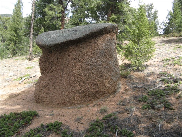
As you observe this feature from close range, you will notice the undercut sides, especially on the southwest exposure, which are not commonly seen in this area. To log this earth cache, you will have to think about some factors that led to the development of this shape.
Weathering Processes acting on Granite
Although granite is normally considered to be a long lasting and hard material, it does eventually break down into its constituent minerals and the byproducts of their decomposition. The processes that lead to this breakdown are normally grouped into physical and chemical, although they often occur at the same time.
The physical processes include expansion during uplifts as the external pressure and temperature is reduced to atmospheric from higher pressures and temperatures deep underground, which may cause cracks to form along axes of mineral weakness. Wind carrying particulate and flowing water containing granular material also can erode the exposed surfaces. Daily and seasonal thermal cycling can result in extension of cracking, and sporadic events such as forest fires represent more severe but occasional events with exaggerated impact. Freeze and thaw cycles act on water trapped in the rock to act as a wedge to expand the cracks, since ice has about 10% greater volume per pound than liquid water. And local events such as tree root growth and animal burrowing can add to the physical forces due to other mechanisms and accelerate breakdown of the “solid” rock. These are the primary process for granite domes that are exposed to the atmosphere on all sides except the bottom, and are relatively slow in geologic terms. They result in rounded tops and boulder shapes, as well as talus on the slopes below the granite outcrops, while the outcrops themselves appear to be competent rock.
The chemical processes are dependent on the development of the minerals making up the granite matrix at a significant depth underground, where the temperature and pressure are higher than at the surface. The minerals in the granite were chemically stable at the conditions when they formed (high temperature and pressure), but some are not very stable at near-surface conditions. When water flows over the surface and through the cracks in the granite, especially when it contains dissolved oxygen, and forms a weak carbonic acid from dissolved carbon dioxide, it can cause chemical reactions at the boundaries of the flow path, resulting in transport of ions between the phases. The presence of organic constituents in the soil and lichen can add to the complexity of the acidic properties of the ground water.
The primary minerals of granite are distinctly different in their resistance to degradation from this weak acid, with those minerals containing calcium, sodium and potassium readily being leached of those ions and converted into clay minerals including kaolinite. Also, the local granite contains significant iron-containing minerals (hence the pink color), which are converted by dissolved oxygen into iron oxides (the process of oxidation or rusting). Other reactions include the breakdown of biotite mica and hornblende into clay minerals, some types of which expand when they absorb water (expansive clays). The least reactive mineral within the granite is quartz, which is quite hard and its durability provides the significant properties that result is granite’s strength.
Although it is not a factor in this case, chemical weathering can also occur without flowing water, as can be seen with the degradation of granite monuments in atmospheres with significant air pollution, especially with sulfur compounds, as well as from acid rains.
The rate of chemical degradation is accelerated when the granite is buried beneath the ground surface because there is more frequent contact with flowing water, and it stays in contact for a longer duration than for granite above the surface. It is useful to think of the subsurface environment in this kind of area as three zones. The one closest to the surface and reaching down to what is known as the water table is called the vadose zone, and contains the a combination of organic material (from plant decay) and inorganic materials (from rock degradation, e.g. decomposed granite). It is relatively coarse and well drained, and has water flow from snow melt and rainwater on a periodic basis. The next zone below the top of the water table is generally water saturated. Water flows through this second zone toward the creeks that drain the areas, but since the presence of water is relatively constant, and flow through the compacted “soil” is relatively slow, the concentrations of ions is relatively close to equilibrium, and with the relative low oxygen content of this dense material, the rate of chemical reaction is significant but often much slower than in the vadose zone. Below the water saturated zone, the basement bedrock is located, with its cracks that can conduct water but generally very low concentration and transport of water due to the essentially solid rock content. So you can imagine the underground zones as a gradient of permeability and reactivity from higher at the surface to lower at the solid bedrock. In the intermediate zone below the water table, this environment results in a chemical composition change without a significant change in the material’s volume, and this modified softer and friable material is known as saprolite.
Lichen and its impacts on weathering
Lichen on the exposed rock surfaces has several interesting effects on the degradation of rock. What we call lichen is not a plant but is a symbiotic relationship between a fungus and an algae, and this association can be hundreds or thousands of years old. The fungus provides the structure, and can cling to bare rock using hyphae, somewhat analogous to roots without providing a path for delivering water to the organism. The algae use the structure for support, and uses photosynthesis with sunlight to convert organic material into food (sugars), which also feeds the fungus.
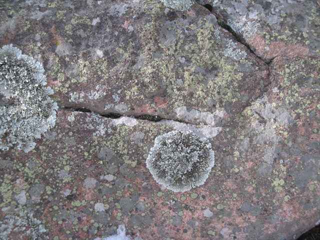
Lichens contribute to rock weathering through several mechanisms. Lichen can hold up to three times its dry weight in adsorbed water, and the resulting expansion and contraction can wedge existing cracks in the rock, as well as cause the breaking off of small grains during contraction. The algae exhales CO2 and inhales oxygen, so lichen adds to the formation of carbonic acid at the rock surface. But lichen also excrete oxalic and other acids, which can have a stronger impact on minerals than carbonic acid. Oxalic acid can readily absorb metal ions to form oxalates through the chelation process. But the deposition of these insoluble metal oxalates also can have a coating effect at the rock surface, seen as a patina, providing some retardation of the weathering processes. Lichens can also provide shade to the rock surface, provide some protection from hail and airborne particles, and increase the boundary layer for air and water flow over the surface. The gripping power of lichen is also known to provide cohesion to granular soils, and may help hold the surface of the rock together to some extent.
But since most people don’t think about geologic time, we need to remember that all of these processes are relative slow, and take many thousands of years to turn hard granite into the inorganic portion of clay-type soils.
Specific Examination of this Granite Mushroom
With sedimentary rock mushrooms, there is often a specific difference in the type of rock in the cap and in the stem, usually with the stem material more prone to erosion effects. This type of layering of rock of various compositions and hardness is usually associated with the deposition of silt or sand or sea creature shells by gravity into deep layers at the bottom of a sea, which after being buried by more layers, are turned into rock like sandstone and limestone. This type of mushroom rock can be found, for example, at Mushroom Rock State Park in Kansas (GC1TEXJ).
Examine the cap of this outcrop, and decide if there is a difference in rock structure between the two parts of the mushroom.
Question 1) Is the cap made of the same material as the stem? What differences can you observe on the surface of the cap compared to the surface of the southwest exposure of the stem?
Question 2) Describe the structure of the surface of the southwest exposure of the stem. Can you distinguish between the different minerals of the granite? What size is typical for the pieces (or clasts) remaining that are separated from others by visible cracks between minerals?
Consider what happens to the granular material that results from the decomposition of granite on a slope of this type. Also think about how the natural surface waterways (creeks and rivers) drain the area, and create canyons in the landscape.
Question 3) How does the surface profile of the soil compare to the lower surface of the cap? Do you think that the soil surface level has changed over the past short period of geologic time?
Question 4) Assuming that this stem was significantly weathered in the vadose zone, and then the natural erosion of the soil over time exposed it to the atmosphere, what has caused the more significant undercutting of the cap on the southwest exposure compared to the north exposure?
Requirements for Logging this Earth Cache
Send an email to the cache owner, StauntonSP.geocache@gmail.com with the answers to the questions above, and you can include a picture of yourself at the site (optional). If your answers indicate that you may not have visited the site, or read the background information, the log may be deleted. Please do not post pictures in the log that help others answer the questions.
References:
- Weathering, from Wikipedia, the free encyclopedia (2015)
- C.R. Twindale and J.R. Vidal Romani 2005. Landforms and Geology of Granite Terrains. A.A. Balkema Publishers, Leiden, Netherlands.
- M.A. Sequeira Braga, H. Paquet, and A. Begonha 2002. Weathering of Granites in a Temperate Climate (NW Portugal): Granitic saprolites and arenization. CATENA, Science Direct, Elsevier B.V.
- Jie Chen, Hans-Peter Blume, and Lothar Beyer 2000. Weathering of rocks induced by lichen colonization – A review. CATENA, Science Direct, Elsevier B.V.
- David P. Dethier and Dana J. Bove 2011. Mineralogic and Geochemical Changes from Alteration of Granitic Rocks, Boulder Creek Catchment, Colorado. Vadose Zone Journal, Soil Science Society of America.
 This earth cache is located within Staunton State Park, which has one public entrance along S. Elk Creek Road, six miles west of Conifer, about 1.5 miles off U.S. Highway 285. Parking along either side of S. Elk Creek Road and Upper Ranch Road adjacent to the park boundary is prohibited. All vehicles entering the park must have a daily park pass ($10) or a CO state park annual or special pass.
The Park is open year-round, and day use hours at 6:00 am to 10:00 pm. A walk-in campground (up to ¼ mile from parking) is open for public use, and overnight parking is currently permitted only for those staying in the campground. During summer and autumn weekends, the park may reach capacity, and cars are allowed to enter only if a parking space is available. Horse trailers are admitted if space is available for parking trailers in a new, dedicated, unpaved parking area. All Park trails are natural surface, some trails are hiker-only, but other trails are multiuse for bicycles and horses also. Information about the park can be found at Staunton State Park website
All visitors must follow park rules and regulations. These include dogs on leash at all times, clean up after pets, travel on developed trails to the extent feasible, leave no trace, respect areas closed for resource management, and be careful around wildlife (especially mountain lions, coyotes, and black bears). Fires are strictly prohibited, except for camp stoves with an on/off switch in the designated campsites and grilles found in the picnic areas. No motorized vehicles are allowed on trails within the Park. An exception is the special tracked chairs that the Park offers to visitors who cannot access selected trails on their own mobility. Pack your own trash out of the back country, and trash receptacles are located near the parking areas. Also, be prepared for changing weather, bring adequate water and footwear, and trails may be snow-covered or icy in winter.