ARCO DO ESPELHO
[S. Miguel – Azores]
EARTHCACHE 
PORTUGUÊS
BAIXA DO ESPELHO
??? BOLHA VULCÂNICA ???
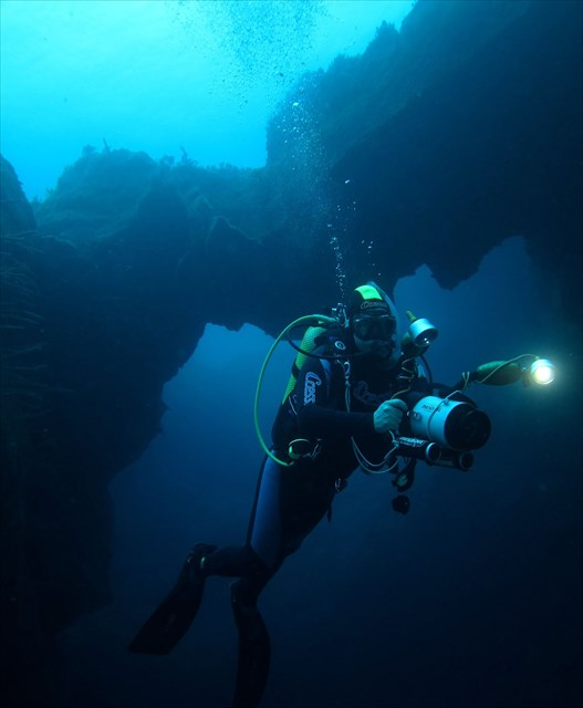
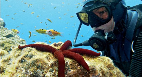
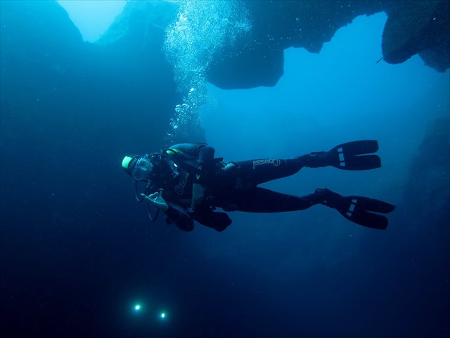
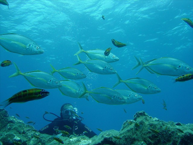
A Baixa do Espelho, também conhecida como Baixa da Relva ou Arco do Espelho, encontra-se em frente à localidade da Relva, a cerca de 200 metros da costa e a cerca de 5 milhas da marina de Ponta Delgada. Com uma profundidade mínima de 6m, este mergulho é acessível a todo o tipo de mergulhadores. O topo da baixa é tipicamente repleto de pequenos peixes coloridos comuns em águas dos Açores, como várias espécies de moreias a espreitar por entre os buracos, pequenos peixes rainha (Thalassoma pavo), e cardumes de salemas (Sarpa salpa) e peixeporco (Balistes carolinensis) em redor da baixa.
Descendo ao longo da parede da baixa encontramos alguns fenómenos interessantes, onde é possível entrar e onde podemos ver algumas ramadas de coral negro (Antipathes wollastoni). Este é também um excelente local para observar cardumes de peixes pelágicos como lírios (Seriola rivoliana), e bicudas (Sphyraena viridensis). Junto ao fundo é por vezes possível ver por vezes ratões de grandes dimensões (Dasyatis pastinaca) imóveis no fundo de areia bem como canários do mar, (Anthia anthia).
Túneis lávicos
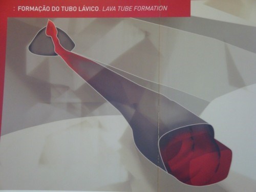
Tubos de lava são condutas naturais através dos quais a lava chega à superfície em um fluxo de lava, expelido por um vulcão em erupção. Eles podem estar ativos quando a lava ainda flui em direção à superfície, ou extintos, o que significa que o fluxo de lava cessou e a rocha esfriou, deixando um longo canal, semelhante a uma caverna. Uma vez que esses tubos são formados simultaneamente à rocha que os envolve, diz-se que são cavernas primárias.
Cavidades Vulcânicas
“As cavidades vulcânicas, não sendo fenómenos geológicos muito comuns, encontram-se em locais do globo onde o magma ascende à superfície, como por exemplo nos Açores, Canárias, Islândia, Itália, Estados Unidos, Japão, Quénia e Coreia.
O arquipélago dos Açores, dada a sua natureza vulcânica e a presença de escoadas lávicas basálticas, apresenta um diversificado património espeleológico.
Podem considerar-se dois tipos principais de cavidades vulcânicas: as grutas ou tubos lávicos e os algares vulcânicos.
Os tubos lávicos resultam do arrefecimento das zonas da escoada lávica em contacto com o ar e as formações envolventes (laterais e em profundidade), formando-se uma crosta mais ou menos endurecida, debaixo da qual continua a escorrer lava ainda quente e fluida. Posteriormente, devido a uma diminuição nas emissões a partir da boca eruptiva, há um abaixamento do nível de lava no interior do tubo, com a formação de um vazio sob a crosta superficial já solidificada. Quando a erupção vulcânica termina, fica formada a gruta ou tubo lávico, podendo, mais tarde, ocorrer abatimentos do teto, com a formação de skylights ou claraboias. Com o decorrer do tempo ocorre, ainda, a colonização dos campos lávicos por plantas, em especial junto às aberturas da gruta”.
Tipos de Escoadas lávicas
As três principais formas que os fluxos de lava podem tomar são:aaouescoriácea,pãhoehoeouencordoada, epillow lavaoulavas em almofada.
ÁREA MARINHA PROTEGIDA (AMP13)
Na sequência da publicação do Decreto Legislativo Regional n.º 15/2007/A, de 25 de junho, que procedeu à revisão da Rede Regional de Áreas Protegidas da Região Autónoma dos Açores, foram criados Parques Naturais de Ilha (PNI) para todas as ilhas do arquipélago. Para além das áreas terrestres, os PNI englobam áreas marinhas já classificadas por diplomas regionais, bem como aquelas instituídas pela Rede Natura 2000, e utilizam a classificação adotada pela União Internacional para a Conservação da Natureza (IUCN).
A Associação dos Amigos do Mergulho, nos Açores, pretende criar na ilha de S. Miguel, 14 Áreas Marinhas Protegidas, sendo uma delas a AMP13- Relva- Baixa do Espelho, local onde se situa este spot de mergulho. O objetivo principal para a existência destas AMP é possibilitar a recuperação e conservação da biodiversidade para o futuro!
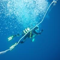
O MERGULHO
O local de mergulho desta earthcache dista cerca de três milhas náuticas da marina de Ponta Delgada, portanto a cerca de quatro minutos do porto de Ponta Delgada.
O mergulho (nível médio - 1/2 de experiência), tem de ser feito de escafandro.
A zona do mergulho é conhecida junto dos entusiastas do mergulho com escafandro, como “BAIXA DO ESPELHO”, situando-se entre 100/200 metros da costa.
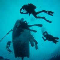
Recomendações:
Convém sempre mergulhar acompanhado.
Tenha sempre em atenção, em primeiro lugar, a sua segurança!

PARA REALIZAR E REGISTAR ESTA EARTHCACHE:
Para realizar earthcaches “submarinas”, é necessário ir ao local, “ver bem” e estudar os fenómenos geológicos envolvidos…, aliás, como para qualquer outra earthcache… Devido às características destas caches, o owner recomendam que o “mergulho” seja bem planeado, com apoio de uma empresa certificada, tendo em atenção as condições meteorológicas (que, nos Açores, variam, por vezes, com grande rapidez) e que se mergulhe sempre acompanhado, como aliás “mandam as regras”.
PERGUNTAS:
Para “encontrar/registar” esta cache deverá: provar que esteve no local e responder às seguintes questões, enviando um email/mensagem de Geocaching, com as respostas, em português ou em inglês, para o nosso perfil.
Só depois, de enviar as respostas, e conforme as “guidelines” para as Earthcaches, deverá efetuar o seu registo!
Serão removidos todos os registos que não obedeçam a estes requisitos.
1. Estudando os temas geológicos propostos nesta earthcache, responde às seguintes questões científicas e históricas:
a) Explica o que é um tubo lávico.
b) No fundo da “formação” existente no GZ, é possível também observar escoadas lávicas! Neste caso, são de que tipo?
c) Caracteriza a estrutura em arco, quanto à constituição da rocha que o compõe.
d) Explica como se terá formado o fenómeno existente no GZ.
2. Observando o GZ desta earthcache - “Arco do Espelho”, responda às seguintes questões:
a) Quantas entradas tem a gruta/arco?
b) Carateriza o fundo dentro do fenómeno existente no GZ.
c) A que profundidade se encontra o fundo desta formação?
d) O cimo do arco fica a que profundidade?
e) Junto deste fenómeno existe uma parede! Qual a altura desde o seu topo até ao fundo.
3.
TAREFA OBRIGATÓRIA:Deverá tirar uma foto sua, onde você apareça (ou com um papel/placa onde conste o seu nickname e a data da visita) e que comprove a sua presença no GZ desta EC - NÃO METASPOILERS. Esta foto deverá ser colocada no seu registo ou enviada por email ou sistema de mensagens de Geocaching, para o owner!
AGRADECIMENTOS:
Agradecemos a especial colaboração dos amigos mergulhadores João Gonçalves e Emanuel Cabral (Nélinho).
Não responderemos ao seu contato, a não ser que haja algum “problema” com as suas respostas ou registo.

Mirror arch
[S. Miguel - Azores]
ENGLISH

EARTHCACHE
“BAIXA DO ESPELHO”
??? BUBBLE VOLCANIC ???
The "Baixa do Espelho", also known as "Arco do Espelho", is in opposite fromthe Town Grass, about 200 meters from the coast and about 5 nautic miles from the marina of Ponta Delgada. With a minimum depth of 6 m, this dive is accessible to all types of divers. The top of the low is typically filled with small joint colorful fish in Azorean waters, as several species of moray eels peeking through the holes, small queen fish (Thalassoma pavo), and schools of salemas (Sarpa salpa) and pigfish (Balistes carolinensis ) around the lower.
Down along the low wall there can be found some interesting phenomena, where you can go and where we can see some black coral fences (Antipathes wollastoni). This is also a great place to observe schools of pelagic fish like lilies (Seriola rivoliana) and barracuda (Sphyraena viridensis). Sometimes it is possible to see large stingrays along the bottom(Dasyatis parsnip) properties in the sandy bottom and sea canaries, (anthia Anthia).
LAVA TUNNELS
Lava tubes or Lava Tunnels, are natural conduits through which lava reaches the surface in a lava flow, expelled by a volcano erupting. They can be active (when the lava still flows toward the surface), or extinct, meaning that the lava flow ceased and the rock cooled, leaving a long channel, similar to a cave. Since these tubes are formed simultaneously with the rock which involves, it is said that these are the primary caves.
Volcanic cavities
"The volcanic cavities, not being a very common geological phenomena, are in the globe where the magma rises to the surface, such as the Azores, the Canary Islands, Iceland, Italy, USA, Japan, Kenya and Korea.
The Azores archipelago, given its volcanic nature and the presence of basaltic lava flows, presents a diverse speleological heritage.
One can consider two main types of volcanic cavities: the caves or lava tubes and volcanic grottos.
The lava tubes resulting from the cooling of lava zones disposed in contact with the air and surrounding formations (lateral and depth), forming a more or less hard crust beneath which continues to flow still warm and washing fluid. Subsequently, due to a decrease in emissions from eruptive mouth washes level there is a lowering in the tube, with the formation of a void in the surface crust already solidified. When the volcanic eruption ends, is formed cave or lava tube, which may later occur ceiling rebates, with the formation of skylights or skylights. With the passage of time is also the colonization of plants by lava fields, particularly near the cave holes ".
Lava flows types
The three main ways that the lava flows can take are: aa or escoriaceous, pahoehoeor corded, and pillow lava.
Marine Protected Area (AMP13)
Following the publication of the Regional Legislative Decree No. 15/2007 / A of 25 June, which revised the Regional Network of Protected Areas of the Azores, were created Island Nature Parks (NIP) for all islands of the archipelago. In addition to the land areas, the NIP include marine areas already classified by provincial laws, as well as those imposed by the Natura 2000 network, and use the classification adopted by the International Union for Conservation of Nature (IUCN).
The DivingFriends Association of in the Azores want to create at the island of São Miguel, 14 Marine Protected Areas, one of which the AMP13- Relva- “Baixa do Espelho” (Low mirror), where is located this dive site. The main purpose for the existence of these AMP is to enable the recovery and conservation of biodiversity for the future!
DIVING:
The dive site is located around this EarthCache three nautical miles from Ponta Delgada marina, so , about four minutes from the port of Ponta Delgada.
Diving (average - 1/2 of experience) this cache must be made diving.
The diving area is renowned among diving enthusiasts, as "BAIXA DO ESPELHO",standing between 100/200 meters from the coast.
Recommendations:
You should always dive together.
Always make sure that first comes your safety!
TO PERFORM AND LOG THIS EarthCache:
To perform "underwater" EarthCaches, you must go to the site, "see well" and study the geological phenomena involved ... Moreover, as for any other EarthCache ... Due to the characteristics of these caches, the owner recommend the "dips" are well planned with the support of a certified company, taking into account the weather conditions (which, in the Azores, vary, sometimes very quickly) and that immerse always accompanied, as "the rules say."
QUESTIONS:
To "find / register" this cache must: prove that visited the site and answer the following questions by sending an email / message Geocaching, with answers (in Portuguese or in English, only) to our profile.
Only later, sending the answers, and as the "guidelines" for EarthCaches should make your registration! They will be removed from all records that do not meet these requirements.
1. Studying the geological topics proposed in this EarthCache, answer the
following scientific and historical issues:
a) Explain what is a lava tube.
b) At the bottom of the "formation" existing in GZ, it is also possible to
observe lava flows! In this case, which type are they?
c) What features compose the arch structure, as the establishment of the rock?
d) explains how the existing phenomenon in GZwas formed.
2. Watching the GZ this EarthCache - "Arc Mirror", answer the
following questions:
a) How many entries does the cave / archhave?
b) characterize the bottom within the existing phenomenon in GZ.
c) How deep is the bottom of this formation?
d) How deep is the top of the arch?
e) Along this phenomenon exists a wall! What is the height from its
top to bottom.
3.
TASK (not optional): You must take a picture of yourself, where do you show up, (or with a paper / plaque with your geocaching nickname and the date of the visit) and that proves your presence in the GZ of this EC - no spoilers please. This photo must be placed in your log or sent by email or Geocaching messaging system, to the owner!
We do not respond to your touch, unless there is a "problem" with their answers or register.
THANKS:
We appreciate the special collaboration of the divers friends João Gonçalves and Emanuel Cabral (Nelinho).


