"On the north side of Shasta, near Sheep Rock, there is a long cavern sloping to the northward nearly a mile in length, thirty or forty feet wide and fifty feet or more in height,... At the mouth of this cave where the light and shelter is good I found many of the heads and horns of the wild sheep, and the remains of camp fires, no doubt those of Indian hunters who in stormy weather had camped there and feasted after the fatigues of the chase."
- John Muir, 1888 - "Steep Trails" |
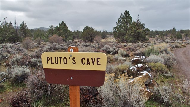
Pluto's Cave
Pluto's Cave is a partially collapsed lava tube on the northern outskirts of Mount Shasta. The tube is roughly 190,000 years old, which is quite old for a lava tube, as they normally collapse quickly (in geological terms), having ceilings only a few metres thick. However, Pluto's Cave is located in a semi-arid climate, where erosion is restricted, which contributes to its survival. The cave was first explored in 1863 by Nelson Cash, who came upon it while looking for stray cattle. He named it Pluto's Cave after Pluto, the Greek God of the underworld. Evidence was found of its use by Pre-Columbian peoples. Visitors can safely hike into the cave about 1200 feet (350 m).
Formation of a Lava Tube
Lava tubes are a type of lava cave formed when an active low-viscosity lava flow develops a continuous and hard crust, which thickens and forms a roof above the still-flowing lava stream. Tubes form in one of two ways: by the crusting over of lava channels, and from pāhoehoe flows where the lava is moving under the surface.
Lava usually leaves the point of eruption in channels. These channels tend to stay very hot as their surroundings cool. This means they slowly develop walls around them as the surrounding lava cools and/or as the channel melts its way deeper. These channels can get deep enough to crust over, forming an insulating tube that keeps the lava molten and serves as a conduit for the flowing lava. These types of lava tubes tend to be closer to the lava eruption point.
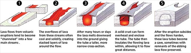
Further away from the eruption point, lava can flow in an unchanneled, fanlike manner as it leaves its source, which is usually another lava tube leading back to the eruption point. Called pāhoehoe flows, these areas of surface-moving lava cool, forming either a smooth or rough, ropy surface. The lava continues to flow this way until it begins to block its source. At this point, the subsurface lava is still hot enough to break out at a point, and from this point the lava begins as a new "source". Lava flows from the previous source to this breakout point as the surrounding lava of the pāhoehoe flow cools. This forms an underground channel that becomes a lava tube.
Whether the tube is formed in a channel close to the eruption site, or is formed within a pāhoehoe flow, when an eruption ceases, temporarily halts or changes direction, the flowing lava can drain out of the tube., forming a lava tube cave.

Pluto's Cave:
Pluto's Cave was formed by an eruption of basaltic lava originating from a vent of Mount Shasta about 8 miles away, between Deer Mountain and The Whaleback. This lava flow reaches as far as Grenada.
This lava tube is one of the main feeder tubes which carried most of the lava into Shasta Valley. The small domes of lava on the surface in the vicinity of the main entrance to the cave are called schollendomes and were formed when the tube was filled with lava to the point where fluid pressure caused an actual inflation of the flow, causing it to rise up, bulge outward and form the small domes on the surface.
Pluto's Cave is unusual in that the diameter of this cave is exceptionally large, larger than many of the major caves in the Hawaiian Islands. The large holes in the ceiling of the cave along its length are known as skylights, and were formed as the lava cooled and the ceiling of the tube collapsed in places.
Entrance to Pluto's Cave
Solid as Rock; Fragile as Glass
Caves have special, sensitive ecosystems. A variety of rare or endangered plants and animals are some of the more significant resources in caves. Important wildlife and vegetation are found near cave entrances, while the interiors are known to support a wide variety of life such as mammals, reptiles, birds, insects and microorganisms. Recent research suggests caves with their unique and varied strains of microorganisms may offer cure to some of the diseases afflicting humans.
Caves are delicate and must be used wisely to avoid damage. Unlike the surface environment, which in time can heal its wounds, a cave, once damaged, remains that way forever. For this reason, visitors are encouraged to:
- Stay on established trails
- Eat and drink outside of the cave
- No human waste, plan ahead! (There is a forest service restroom at the waypoint "Nearest Restroom", .65 miles as the crow flies from the parking coordinates)
- No fires, torches or smoking in the cave
- Treat the cave with respect; refrain from vandalism
- Enjoy rocks, animals, flowers and vegetation, but collect only litter
- Camp only in designated areas; camping is not permitted at Pluto's Cave. It is a Day Use Only area.
Are You Prepared???
- Always go caving with at least one other person
- Each explorer should carry at least two flashlights. Cavers often carry a third emergency light source. To help answer Question 6, one of your flashlights should be at least 200 lumens!
- Expect to get a little dirty. You will be scrambling over rocks at times, and some areas of the cave are pretty dusty
- Wear sturdy, non-skid shoes
- Bring warm clothing; it can be cool inside of the cave
Things to Know before you Go!
- If your GPSr has routing capabilities, DO NOT route to the earthcache itself!! If you do, you will be routed via posted PRIVATE PROPERTY dirt roads to the cache site. This is a BIG no-no!! You will upset the landowners nearby mightily. Instead, route your GPSr to the parking coordinates provided below.
- Old-fashioned Directions: About 10.5 miles outside of Weed, driving northeast on Highway 97, look for the turnoff for Grenada on the left, also known as County Highway A-12 or the 99-97 Cutoff. Drive 3.2 miles northwest on this highway and turn left on a small dirt road where the telephone pole is marked "PLUTO CAVE" in silver letters. Proceed down this dirt road for about a quarter mile to the parking lot.
- Further reading about this nice hike: Pluto Cave Trail
Logging Requirements:
In order to log this earthcache as found, send an e-mail through our geocaching profile with the first line containing " GC5K2R5 Pluto's Cave" and the answers to the following questions based on your observations and information obtained during your visit to the site. You will need to walk most of the length of the lava tube inside the tube, to answer all of the questions. In addition, some internet research and map research may be required to answer some of the questions.
- Place the text "GC5K2R5 Pluto's Cave" on the first line of your email.
- The number of people in your group.
- What are the primary colors, tones and hues of the basalt in the lava tube? e.g.: blacks/grays or reddish-browns, etc.?
- Are layers of different lava flows visible in the tube walls? Is the basalt grainy, fine textured or a combination of textures?
- Waypoint 1: (See cave diagram below) At this unusually round collapse of the lava tube (skylight), estimate the diameter of the circular collapse.
- Waypoint 2: (see cave diagram below) Make your way along the left (west) wall of the cave at this point. You should end up standing next to a large triangular rock against the wall that has white graffiti on it. (See photo below the cave diagram) What is the two-digit number above the name "TOM"?
- With your flashlight, shine your light to the ceiling of the lava tube at this location. How high do you think the ceiling is at this point?
- Which direction do you believe lava flowed through this tube? Why do you believe this? (Perhaps some internet research regarding the location of Deer Mountain and The Whaleback might help with this question!)
- Optional: Post a picture with you and your GPS at the location, making sure not to give away any answers in your photo!
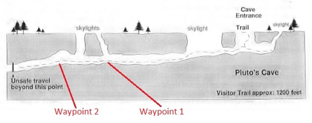
Cross-section of Pluto's Cave
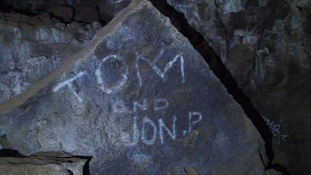
Graffiti Rock at Waypoint 2
Do not include any answers to the above questions in your log, even if encrypted, or we will have to delete your entry. If you do not e-mail us the answers to the above questions within a reasonable amount of time your log will be deleted.
Enjoy your visit! If you appreciated your stop here and the things you learned, please consider awarding this cache a favorite point!
Remember the Caver's Creed:
- Take nothing but pictures
- Leave nothing but well-placed footprints
- Kill nothing but time

|
|
Congrats to
Team Bardini
for snagging the FTF on this earthcache! Well done Sir and Lady Bardini!! |