FAJÃ DO CALHAU
[S. Miguel – Azores]
EARTHCACHE
PORTUGUÊS
FAJÃ DO CALHAU
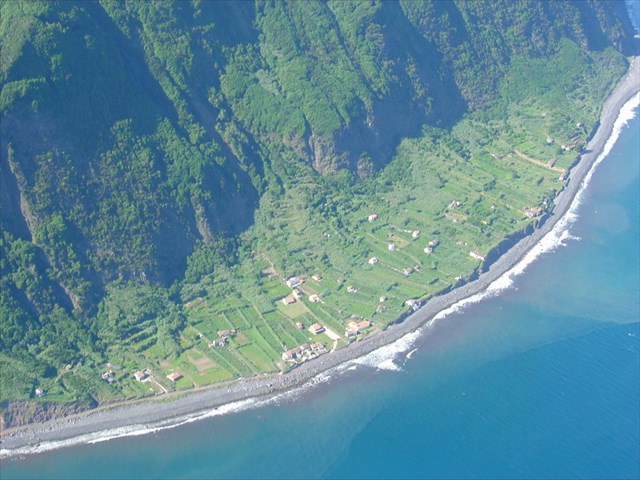
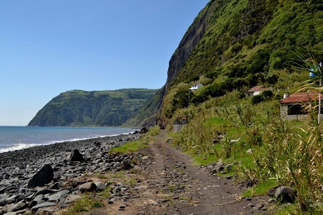
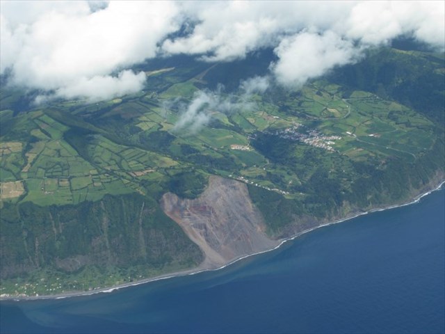
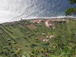
A Fajã do Calhau faz parte do concelho da Povoação, ilha de São Miguel. Esta fajã encontra-se alojada no fundo de uma falésia que desce quase na vertical desde os 440 metros de altitude. Junto ao mar forma uma zona plana onde se encontra uma aldeia e uma extensa área de calhau rolado usada para banhos.
Aqui, e devido ao microclima de características amenas são cultivados certos produtos cujo cultivo não é possível em altitude.
Encontra-se entre as localidades do Faial da Terra e de Água Retorta, o acesso por estrada é feito a partir de uma estrada pela freguesia de Água Retorta. Também é possível chegar a esta fajã, a pé e pelo calhau, a partir da vizinha freguesia do Faial da Terra (conhecida, como o “presépio” de S. Miguel).
Nesta fajã é possível observar várias das espécies de flora endémica da Macaronésia.
Vale da Ribeira do Faial da Terra e Fajã do Calhau
![http://www.azoresgeopark.com/fx/spacer.gif]() Geossítio SMG 10
Geossítio SMG 10![http://www.azoresgeopark.com/fx/spacer.gif]()
“O vale fluvial do Faial da Terra estabelece o limite entre o complexo vulcânico fissural basáltico do Nordeste (a leste, com filões e depósitos de escórias) e as rochas traquíticas do vulcão poligenético da Povoação (a Oeste, com domos e depósitos pomíticos). A Fajã do Calhau é a maior fajã detrítica da ilha”.
AS FAJÃS
Fajã é um termo de origem obscura que designa um terreno plano, em geral cultivável, de pequena extensão, situado à beira-mar, formado de materiais desprendidos das arribas ou por deltas lávicos resultantes da penetração no mar de escoadas de lava provenientes da vertente. Pode-se definir fajã como toda a terra baixa e chã ou como pequena extensão de terreno plano, suscetível de cultura, junto a uma rocha, geralmente à beira-mar, formada em regra por materiais desprendidos por quebradas ou acumulados na foz de uma ribeira e assentes quase sempre num banco de lava muito resistente.
A palavra fajã está expandida em toda a Macaronésia lusófona, sendo muito comum nos Açores, onde aparece em quase todas as ilhas, na ilha da Madeira e em muitas ilhas de Cabo Verde.
Embora o termo fajã seja em geral utilizado para designar plataformas costeiras, é por vezes utilizado na toponímia da Macaronésia em ligação a pequenas zonas planas anichadas junto a montes ou colinas com encostas íngremes. É o caso das zonas aplanadas onde se situam as freguesias de Fajã de Baixo e de Fajã de Cima, na ilha de São Miguel, ambas freguesias interiores sem qualquer ligação à costa. O mesmo acontece com o topónimo Fajã das Ovelhas, um local de altitude, nas faldas norte da Serra de Santa Bárbara, na ilha Terceira. Nesta aceção a palavra confunde-se com o termo achada, também utilizado na Macaronésia para descrever uma zona aplanada entre montes, em especial as plataformas planálticas suspensas entres os grandes vulcões centrais das ilhas e a costa.
Apesar de existirem fajãs em quase todas as ilhas da Macaronésia, elas são mais comuns, ditando em boa parte a distribuição da população, na ilha de São Jorge. Naquela ilha, as vilas sedes dos seus dois concelhos, Velas e Calheta, situam-se em fajãs, o mesmo acontecendo à vila das Lajes do Pico, na vizinha ilha do Pico.
Tipos de fajãs
De acordo com as suas características, origem e localização, as fajãs podem ser classificadas em:
1) Fajãs costeiras– fajãs em contacto direto com o litoral.
Fajãs de delta lávico– fajãs criadas quando as escoadas de lava avançam sobre o mar, provocando o recuo da linha de costa. Estas fajãs, em geral muito resistentes à erosão do mar por serem constituídas por grandes massas rochosas compactas e sem fissuração apreciável, são em geral delimitadas por costas abruptas, angulosas, fortemente recortadas, com grandes calhaus no seu sopé. Os solos, quando não tenha havido recobrimento por materiais de projeção ou derrocadas posteriores, são em geral esqueléticos. À superfície destes deltas podem ocorrer pseudo-crateras ou cones litorais e a erosão da frente da escoada ou uma drenagem posterior conferem-lhe frequentemente um aspeto digitado. São frequentes os arcos rochosos costeiros e as grutas marinhas resultantes da infraescavação pela erosão por ação do mar.
Fajãs de talude (ou fajãs detríticas)– são fajãs criadas pela acumulação de materiais resultantes do desmoronamento das encostas sobranceiras. Estas fajãs tendem a ser mais aplanadas e, por serem constituídas por materiais soltos, facilmente sujeitos ao transporte pelas ondas, têm em geral costas de formas suaves e quase retilíneas, com praias de calhau rolado de dimensão variável. Nas costas mais expostas à ondulação, em geral as viradas a norte, formam-se por vezes cordões de calhaus rolados que conduzem ao aparecimento de formações lagunares (como acontece na Fajã da Caldeira de Santo Cristo). Os solos destas fajãs são em geral muito férteis, embora as mais perigosas, para habitação humana, dada a recorrência dos desmoronamentos. Os grandes terramotos tendem a formar novas fajãs deste tipo, como aconteceu profusamente no grande sismo do Mandado de Deus, na metade leste de São Jorge.
2) Fajãs de altitude e pequenas achadas – fajãs encaixadas em encostas longe do mar, em geral pequenos planaltos ou vales aplainados no sopé de montanhas ou de cones vulcânicos.
Fajãs de encosta– plataformas formadas em consequência de quebradas que deixam plataformas de ablação nas encostas. Em geral de pequena extensão, apresentam pouco interesse para uso humano, mas são importantes como biótopos para espécies que exigem boa exposição solar e boa drenagem.
Fajãs de sopé ou pequenasachadas – são plataformas aplanadas existentes no sopé de encostas ou entre cones vulcânicos. O termo achada resulta do seu interesse como locais privilegiados de cultivo, preferidos para fixação pelos colonizadores quando os achavam no desbravar das ilhas.
PARA REALIZAR E REGISTAR ESTA EARTHCACHE:
PERGUNTAS:
Para “encontrar/registar” esta cache deverá responder às seguintes questões, enviando um email ou mensagem (num prazo de até quinze dias do seu registo com o seu texto em português ou em inglês), com as respostas para o meu perfil:
1. Responde às seguintes questões:
a) Explica, por palavras tuas, o que é uma fajã.
b) Classifica a Fajã do Calhau.
c) Apresenta dois exemplos de outras fajãs do mesmo tipo, existentes na ilha de São Miguel
d) Indica dois exemplos de Fajãs Lávicas existentes nesta ilha.
e) Qual é a altura da falésia que se situa junto à Fajã do Calhau.
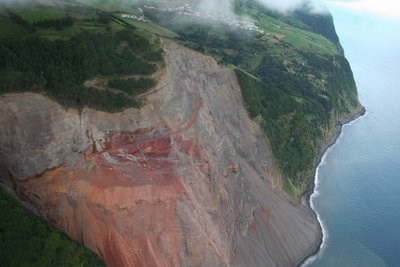
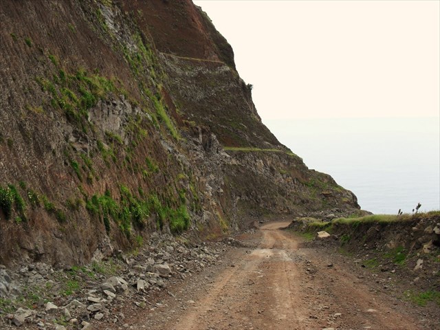
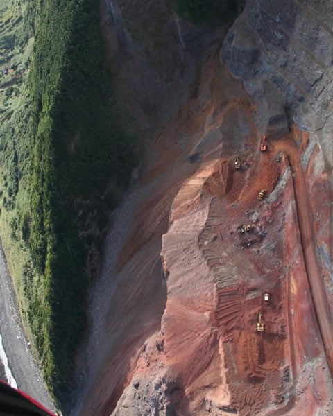
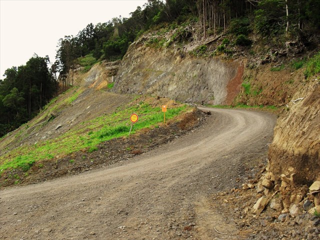
2. Durante a construção da atual estrada de acesso a esta fajã, toda a zona que ficou a descoberto (visível nas várias fotos desta descrição) é vermelha!
a) Qual o nome deste material vermelho?
b) Sempre foi vermelho? Porque razão mudou de cor e ficou vermelho?
3. Observando a zona do GZ responde às seguintes questões:
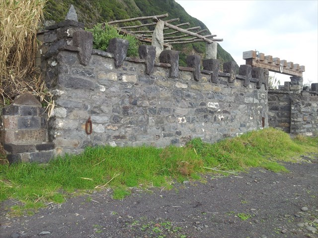
a) Dentro do “castelo” existente na zona, está um “padrão”.
É feito de que material?
b) O que está em cima do sino, existente neste local?
c) Descreve o “brasão de armas”, existente em coma da “porta” deste castelo.
Também e apesar de ser opcional, convidamos a que tire e partilhe no seu registo uma foto sua com o GPS no local do GZ ou, e porque não, enviar uma foto consigo, no GZ, enquadrado pelo “castelo”.
Agradeço o envio de um email ou mensagem com as respostas às questões colocadas, através do meu perfil do Geocaching.
AGRADECIMENTOS:
Agradecemos a especial colaboração do amigo Miguel Cassis, bem como do
Professor Doutor Victor-Hugo Forjaz - Vulcanólogo de Engenharia, Jubilado
e do Observatório Vulcanológico e Geotérmico dos Açores (OGVA).
FAJÃ DO CALHAU
[S. Miguel - Azores]
ENGLISH

EARTHCACHE
“FAJÃ DO CALHAU”
The “Fajã do Calhau” is part of the municipality of the "Vila", in the island of São Miguel. This fajã is housed at the bottom of a cliff that descends almost 440 feets vertically. By the sea a flat area where a village and a large pebble rolled area used for bathing are formed.
Here, due to the mild microclimate characteristics are cultivated certain products whose cultivation is not possible in altitude.
It lies between the villages of "Faial da Terra" and "Água Retorta", the road access is made from a road by "Água Retorta's" parish. You can also reach this fajã, on foot and by pebble, from the nearby village of Faial da Terra (known as the "crib" of St. Michael).
In this fajã you can see several species of endemic flora of from Macaronesia.
“Vale da Ribeira do Faial da Terra e Fajã do Calhau”
![http://www.azoresgeopark.com/fx/spacer.gif]() SMG 10
SMG 10![http://www.azoresgeopark.com/fx/spacer.gif]()
"The river in “Faial da Terra” valley establishes the boundary between the Northeast fissure basaltic volcanic complex (east, with veins and slag deposits) and "traquíticas" rocks of polygenetic volcano Village (West, with domes and "pomíticos" deposits). The “Fajã do Calhau” is the largest detrital fajã of the island. "
THE: “FAJÃS”
“Fajã” is an obscure source term for flat terrain generally arable, of small extent, situated by the sea, formed of material detached from cliffs or lava deltas resulting from the penetration in the sea of lava from the slope disposed. You can set fajã as all the low land and tea or as small tract of land plan, susceptible of culture, next to a rock, usually by the sea, formed usually by loosened materials for broken or accumulated at the mouth of a river and based almost always a very tough lava bank.
The word fajã is expanded throughout the Lusophone Macaronesia and very common in the Azores, where it appears in almost all the islands, the island of Madeira and in many islands of Cape Verde.
Although the term “fajã” is generally used to designate coastal platforms, is sometimes used in places in the Macaronesia in connection to small anichadas flat areas along the mountains or hills with steep slopes. This applies to the flattened areas where are the parishes of Faja de Baixo and Faja de Cima on the island of São Miguel, both inland parishes without any connection to the coast. The same applies to the place-name Faja the Sheep, a place of altitude, in the northern foothills of the Sierra de Santa Barbara, Terceira. In this meaning the word is confused with the term found, also used in Macaronesia to describe a flattened area between hills, especially plateau suspended platforms between major central volcanoes of the islands and the coast.
Although there are “fajãs” in almost all the Macaronesian islands, they are more common, largely dictating the distribution of population on the island of São Jorge. On that island, villages headquarters of its two counties, "Velas" and "Calheta", are located in coves, as has the village of Lajes do Pico, on the neighboring island of Pico.
Types of “Fajãs”
According to its characteristics, origin and location, the coves can be classified into:
1) Coastal Fajãs- fajãs in direct contact with the coast.
Fajãs of lava delta- fajãs created when lava drained advance of the sea, causing the retreat of the shoreline. These coves in very resistant to erosion by the sea usually are made from large rock masses and compact without appreciable cracking, are generally bounded by abrupt back, angular, heavily cut, with large pebbles in his foot. The soils, when there was no covering for projection of material or subsequent landslides, are generally skeletal. On the surface these deltas may occur pseudo-craters or coastal cones and the front of the erosion of drained or a later drainage often give it a typed aspect. Are frequent coastal rocky arches and sea caves resulting from infraescavação erosion by action of the sea.
Slope Fajãs (or fajãs detrital)- fajãs are created by the accumulation of materials resulting from the collapse of hillsides. These fajãs tend to be flattened, and are constituted by loose material easily subject to transportation waves, have generally smooth back and almost rectilinear shapes with rolled pebble beach variable dimension. In the most exposed back to the waves, in general face north, formed sometimes pebbles rolled seams that are resulting in lagoon formations (as in the Faja Caldeira de Santo Cristo). The soils of these coves are very fertile general, although the most dangerous for human habitation, given the recurrence of landslides. The great earthquakes tend to form new coves such as profusely happened in the great earthquake of Warrant of God, in the eastern half of St. George.
2) Fajãs altitude and small found- fajãs fitted on slopes away from the sea, usually small plateaus or flattened valleys at the foot of mountains or volcanic cones.
Slope of coves- platforms formed as a result of broken leaving ablation platforms on the slopes. Generally of small extent, have little interest for human use, but are important as biotopes for species that require good sun exposure and good drainage.
Foot of coves and small found- are flattened existing platforms in the slopes of the foot or between volcanic cones. The term results found of interest as privileged places of culture, preferred for fixing by settlers when they thought the blaze in the islands.

TO PERFORM AND LOG THIS EarthCache:
QUESTIONS:
To "find / register" this cache you must answer the following questions by sending an email or message
(within 15 days of registration with text in Portuguese or in English),
with the answers to my profile:
1. Answer the following questions:
a) Explain, in your words, what is a fajã.
b) Classify Faja do Calhau as a type of fajã.
c) provide two examples of other fajães of the same type, existing on
the island of São Miguel
d) indicate two examples of lava Fajãs existent in this island.
e) What is the height of the cliff located close to Fajã do Calhau.
2. During the construction of the current access road to this fajã, the whole area that was uncovered (visible in the various pictures of this description) in red!
a) What is the name of this red stuff?
b) Was it always red? Why has the color changed to red?
3. Observing the GZ zone answer the following questions:
a) Within the "castle" existing in the area, there is a "pattern".
What material is it made of?
b) What is on the bell, existing on this site?
c) Describe the "coat of arms"(sign), existing in a coma the "door"
of this castle.
Also and despite being optional, we invite you to take and share a photo in your registration with GPS on site or the GZ, and why not, send a picture framed by one the “castle”.
Please send me an email or message with the answers to these questions via my Geocaching profile.
THANKS:
We appreciate the special collaboration of the friend Miguel Cassis and the
Professor Victor-Hugo Forjaz - volcanologist Engineering, Emeritus
and the Volcanological and Geothermal Observatory of the Azores (OGVA).