CALOR DA TERRA


CALDEIRAS DA RIBEIRA GRANDE
[S. Miguel – Azores]

EARTHCACHE

PORTUGUÊS

O VULCÃO DO FOGO
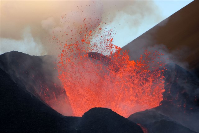
O vulcão do Fogo (Estratovulcão, vulcão central, vulcão poligenético com caldeira), dá forma ao grande maciço vulcânico da Serra de Água de Pau, localizado na zona central da Ilha de São Miguel. Toda esta zona é rodeada por uma densa e exuberante vegetação endémica. A caldeira vulcânica, tal como o vulcão, que lhe deu forma, é a mais jovem da Ilha de São Miguel e ter-se-á formado há cerca de 15 000 anos. A sua configuração atual é resultado do último colapso, tido como importante e que ocorreu no topo do vulcão, há aproximadamente 5 mil anos. A última erupção data de 1563.
Fumarolas e “caldeiras”…
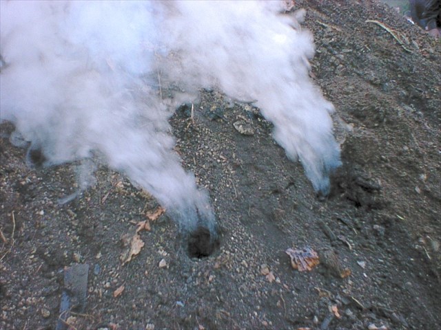
As fumarolas constituem emanações de vapor de água e de gases que se formam através de aberturas na superfície da crosta da Terra e estão normalmente presentes em zonas com vulcanismo ativo, normalmente em períodos entre erupções vulcânicas. São comuns nos flancos dos vulcões, bem como em crateras e caldeiras. Todas as fumarolas exigem tanto calor e uma fonte de gás ou água. Podem ocorrer ao longo de pequenas fissuras, formando alinhamentos, ou em zonas de fratura, tais como caixas de falha, onde formam por vezes extensos campos de fumarolas em áreas onde uma fonte de calor superficial vulcânica é sobreposta por uma rocha permeável.
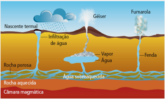
Nas zonas onde ocorrem rochas ígneas quentes, onde o nível freático aproxima-se da superfície ou em zonas de desgaseificação das formações, onde o magma subjacente está a libertar gases como dióxido de carbono, constituem-se áreas de concentração de nascentes (ou fontes) termais ou outras manifestações geotérmicas, como geiseres, "mudpots", terraços de sílica, etc. Só se o vapor atinge a superfície é que ocorre a fumarola. Podem ocorrer situações em que dá-se a emissão de água quente durante a estação chuvosa e de fumarolas na seca, quando há menos água subterrânea para condensar o vapor. As fontes termais são mais comuns que os outros tipos de manifestação geotérmica.
Quanto às emissões, a maior fonte de vapor de água é a água subterrânea aquecida por magma relativamente próximo à superfície. Além do vapor de água e do dióxido de carbono (CO2), emitem gases como dióxido de enxofre (SO2), ácido hidroclórico (HCl) e sulfureto de hidrogénio (HS), provenientes diretamente do magma. Uma fumarola rica em gases sulfurosos diz-se “sulfatara”. Alguns geólogos utilizam os termos “fumarola” e “solfatara” indiscriminadamente, independentemente do seu teor de enxofre, utilizando o termo “mofeta” os casos em que a libertação de gases é rica em CO2.
A saída dos gases pode ser agressiva e dá-se a temperaturas variáveis, podendo atingir facilmente os 95º C à superfície e 130º C a apenas meio metro de profundidade. Esses gases são constituídos quase na totalidade por CO2 (95%), seguindo-se H2S (gás sulfídrico 3%), hidrogénio (H2) azoto (N2) e metano (CH4), em percentagens muito baixas. Em consequência das desgaseificações sobreaquecidas e quimicamente agressivas, as rochas circundantes alteram-se para materiais argilosos, associados a minerais secundários, tais como o enxofre em massas e em cristais (cor amarela), óxidos de ferro (avermelhados) e ainda os óxidos de alumínio (esbranquiçados), alguns destes materiais com propriedades terapêuticas.
A intensidade dos gases libertados e a sua visibilidade variam consoante o estado de recarga dos aquíferos, da humidade relativa do ar (que pode tornar o vapor emitido bem mais espesso) entre muitos outros fatores, pode variar a intensidade dos gases libertados e a sua visibilidade. Ocorrem por vezes grandes variações diárias e sazonais no funcionamento das fumarolas, não querendo dizer contudo que haja alterações no vulcanismo do local.
Outros tipos de emanações geotérmicas
As nascentes em ebulição ou alcalinas advêm de águas geotérmicas profundas que atingem a superfície. São claras e depositam sílica dissolvida à medida que arrefecem. Este material rígido branco-cinza pode ser composto de carbonato de cálcio em algumas localizações. No que concerne aos geiseres, estes formam-se quando a água subterrânea sobreaquecida e sob grande pressão hidrostática sobe através de uma crosta muito fina até a superfície, permitindo-lhe formar vapor superaquecido forçando a água a subir acima da superfície. Os geiseres são distintos das nascentes termais e das fumarolas devido aos seus sistemas especializados, enquanto a diferença entre uma nascente termal e uma fumarola refere-se simplesmente á temperatura. Se a fonte de calor não é suficiente forte para ferver a água, surge uma fonte termal.
Num "mudpot" a água é ácida, dissolvendo as rochas circundantes e misturando-as com a água. Cria-se um banho de lama, em que as bolhas de gases escapam por baixo da crosta. O calor e o gás advêm do magma ou de massas de rochas vulcânicas recém-expulsas e também da água proveniente da precipitação, que se infiltra no solo.
Um campo geotérmico é criado na presença de água, calor e acesso rápido da água geotérmica à superfície. A água fria da chuva passa através de fissuras nas rochas em direção a uma fonte de calor geotérmico, aquecendo à medida que desce. Em seguida, sobe rapidamente para a superfície na forma de geiseres, fumarolas ou fontes termais.
Exemplos de Fumarolas nos Açores
-Fumarolas das Furnas, na ilha de São Miguel, associadas a geysers e a nascentes termais;
-Fumarolas da Lagoa das Furnas, muito conhecidas por serem utilizadas como local de confeção de refeições (o cozido das Furnas);
-Fumarolas do Fogo da Ribeira Quente, sitas na zona urbana da freguesia da Ribeira Quente, sendo comuns ao longo das sarjetas da rua do Fogo;
-Fumarolas da Caldeira Velha, na Ribeira Grande;
-Fumarolas da Ribeira Seca, na zona urbana da freguesia da Ribeira Seca, já obrigaram ao abandono de várias habitações por introduzirem gases tóxicos nas condutas de esgoto;
-Furnas do Enxofre,na parte central da Terceira;
-Furna do Enxofre, Graciosa. Situadas no interior da grande gruta da Furna do Enxofre, mantém uma cavidade repleta de lama em ebulição e libertam monóxido de carbono que já causou a morte a alguns visitantes;
-Fumarolas das Velas, fumarolas submarinas no interior da baía de Velas (junto ao Cais da Queimada), ilha de São Jorge, por vezes visíveis pelo “borbulhamento” à superfície;
-Fumarolas do Piquinho, fumarolas sitas no topo do Pico da ilha do Pico, a cerca de 2350 m de altitude acima do mar. Por vezes vê-se, desde a cidade da Horta, o ténue vapor que libertam.
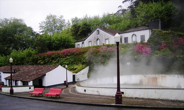
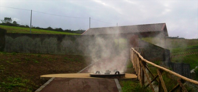
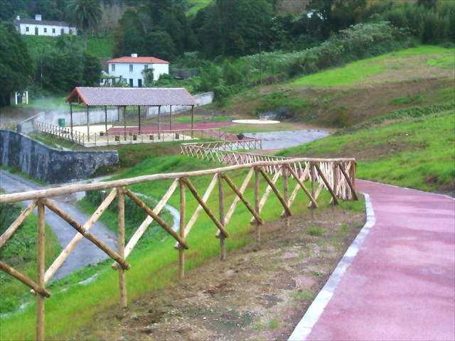
CALDEIRA DA RIBEIRA GRANDE
Situada na zona Norte da Ilha de são Miguel, no bonito concelho de Ribeira Grande, no fantástico Arquipélago dos Açores, a Caldeira da Ribeira Grande é testemunho vivo das manifestações vulcânicas desta Ilha.
Num local de paz de espírito e calmaria, na Caldeira da Ribeira Grande misturam-se as águas fumegantes que brotam a altas temperaturas, cujo vapor alimenta a verdejante vegetação que a circunda, que é também a imagem da própria “Ilha Verde”.
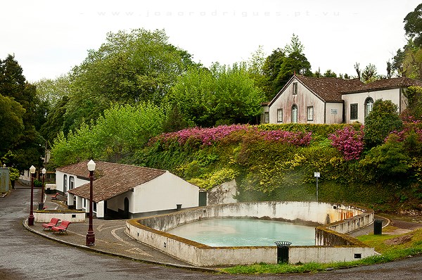
TERMAS DA RIBEIRA GRANDE
As Termas das Caldeiras da Ribeira Grande (Ribeira Grande) são um conjunto termal localizado no interior da ilha de São Miguel no concelho da Ribeira Grande tendo como data de construção o século XIX. Apresentam-se como um conjunto paisagístico formado num vale atravessado por uma ribeira e envolvido por vegetação cuja cobertura vegetal é rica e povoada por espécies típicas das florestas da Laurissilva.
A vegetação foi usada, tanto quanto possível para fazer bardos e delimitações nos espaços públicos e também nos privados dando assim forma a espaços íntimos que contribuem para a envolvência das construções que se veem assim num ambiente peculiar. Estas termas são formadas por um conjunto de edifícios alinhados ao longo de uma via de comunicação que atravessa e por outros dispersos nas encostas próximas.
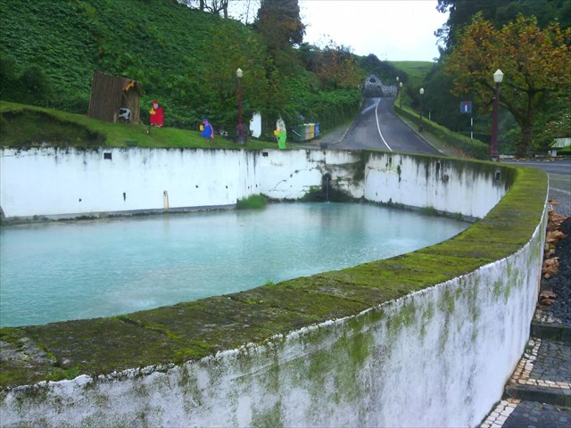
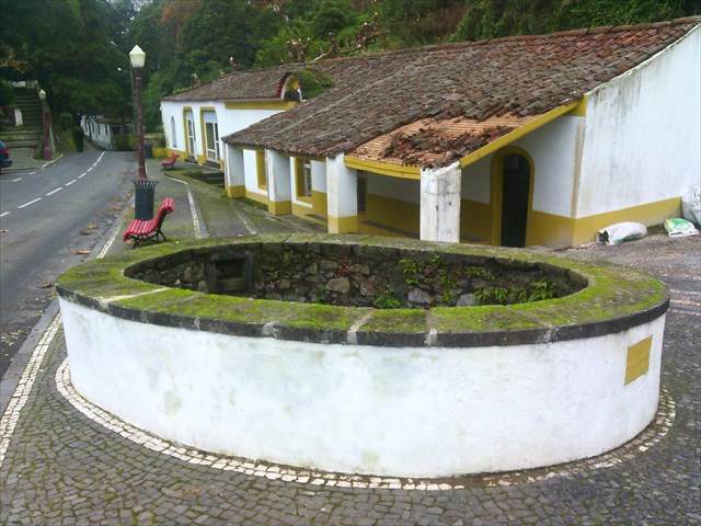
Na zona central do vale encontra-se uma caldeira de águas ferventes de grandes dimensões, cujas águas em tons azul claro estão em contínua ebulição com a consequente desgaseificação para o meio ambiente. No edifício termal do século XIX e no outro lado da via, existe uma "fumarola" junto à qual foi construído de três tanques de pedra para receberem água quente natural e grelhadores para refeições ao ar livre. No ponto mais elevado deste conjunto arquitetónico existe uma ermida que foi rodeada de um adro, local de onde é possível avistar todo o conjunto termal. Neste local existem casas de habitação que na sua maioria tem de um ou dois pisos. As construções existentes foram edificadas em alvenaria de pedra rebocada e pintada a branco. A cobertura das mesmas é feita a telha de meia-cana com telhão na cumeeira. Os espaços públicos foram requalificados e têm uma presença marcante na paisagem.
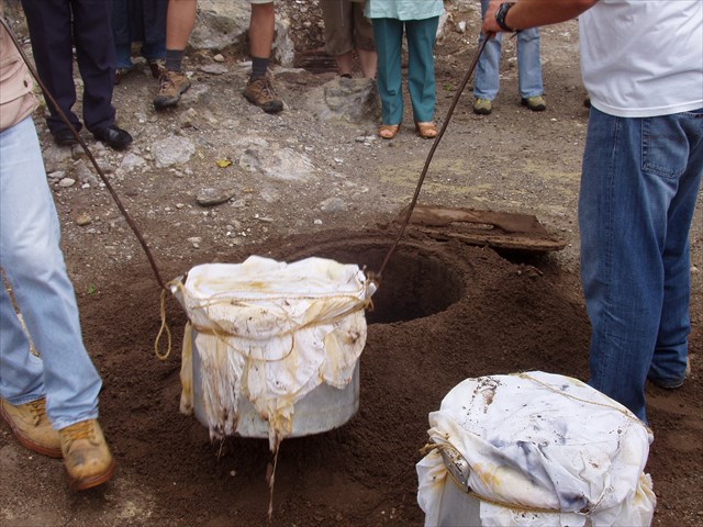
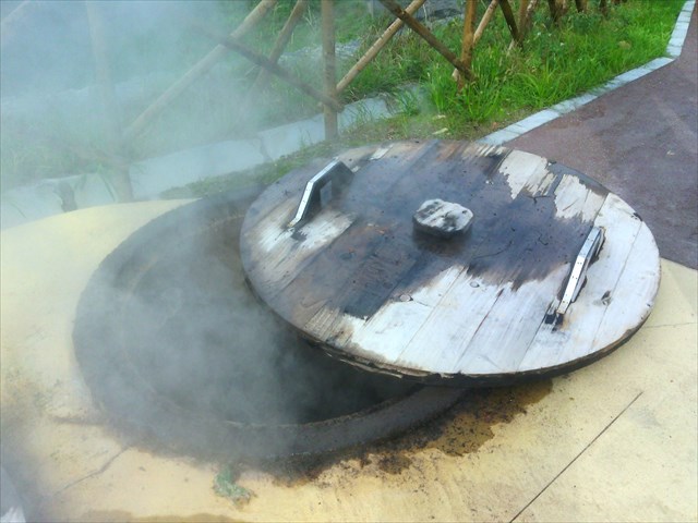
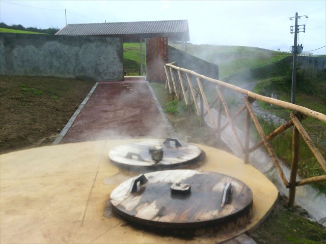
COZINHAR NAS CALDEIRAS
A Ribeira Grande, nos Açores, disponibiliza gratuitamente, desde o verão de 2014, “covas” no solo para a confeção dos tradicionais cozidos aproveitando o calor da terra vulcânica, um projeto que a autarquia diz estar a registar uma "grande adesão". Estão disponíveis vários buracos para confeção gratuita e durante cinco a seis horas dos cozidos na zona das Caldeiras da Ribeira Grande, que resultam do aproveitamento do calor geotérmico, à semelhança do que acontece nas Furnas, também na ilha de São Miguel.

PARA REALIZAR E REGISTAR ESTA EARTHCACHE:
PERGUNTAS:
Para “encontrar/registar” esta cache deverá: provar que esteve no local e responder às seguintes questões, enviando um email/mensagem de Geocaching, com as respostas, em português ou em inglês, para o nosso perfil.
Só depois, de enviar as respostas, e conforme as “guidelines” para as Earthcaches, deverá efetuar o seu registo!
Serão removidos todos os registos que não obedeçam a estes requisitos.
1. Responde às seguintes questões:
a) Classifica o vulcão responsável pelos fenómenos observáveis no GZ, WP1 e WP2.
b) Em que ano se deu a última erupção deste vulcão?
c) Explica, por palavras tuas, o que é uma fumarola.
d) Identifica, pelo menos três, fenómenos secundários de vulcanismo, presentes nesta zona.
2. Observando a zona do GZ responde às seguintes questões:
a) Descreve a água dentro das duas “caldeiras” que vês na zona, referindo: a cor, a temperatura e o estado.
b) Quantas “entradas” e “saídas” de água, consegues observar na caldeira “grande”, que se localiza no GZ?
c) Quantos “arcos” de pedra, se conseguem visualizar dentro da caldeira grande?
d) Qual é a data que se encontra junto à coroa, na frontaria do edifício das Termas, no GZ?
3. Observando a zona dos cozidos (WP1 e WP2), responda às seguintes questões:
a) Quantos “buracos de cozido” existem no WP1?
b) E no WP2?
c) Qual é o tempo mínimo (numa situação normal) de cozedura dum cozido, nestas covas?
4. TAREFA 1:faz um “croqui”/desenho, da zona dos cozidos, que englobe todos os buracos existentes, bem como todas as estruturas existentes (WP1 e WP2) e envia-a por email (para: lfbcmmachado@sapo.pt)
5.
TAREFA 2 - OBRIGATÓRIA:Deverá tirar uma foto sua, onde você apareça (ou com um papel/placa onde conste o seu nickname e a data da visita) e que comprove a sua presença no GZ desta EC - NÃO METASPOILERS. Esta foto deverá ser colocada no seu registo ou enviada por email ou sistema de mensagens de Geocaching, para o owner!

Não responderemos ao seu contato, a não ser que haja algum “problema” com as suas respostas ou registo.


INFORMAÇÕES:
Esta cache fez parte da Geotour Ilha Verde/GreenIsland (a primeira GeoTour portuguesa), entre 18 de junho de 2015 e 18 de junho de 2016..
Earth's Heat
“CALDEIRAS DA RIBEIRA GRANDE”
[S. Miguel - Azores]
ENGLISH

EARTHCACHE

“ FOGO” VOLCANO
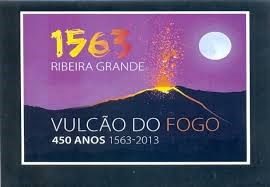
The Volcano of “Fogo” (Stratovolcano, central volcano, polygenetic volcano with boiler), forms the great volcanic massif of the Sierra of “Agua de Pau”, located in the central area of São Miguel Island. This whole area is surrounded by a dense and lush local vegetation. The volcanic crater as the volcano, which gave it form, is the youngest of the island of São Miguel and will have formed some 15 000 years. Its current configuration is the result of last collapse, seen as important and that occurred at the top of the volcano, there are about 5000 years. The last eruption date 1563.
Fumaroles and boilers
The steam vents are water vapor fumes and gases that are formed through openings in the surface of the earth's crust and is typically present in areas with volcanic activity, usually during periods of volcanic eruptions. Are common on the flanks of volcanoes and craters and boilers. All fumaroles require both heat and a source of gas or water. Can occur over small cracks forming alignments, or fracture zones, such as failure boxes, which often form large fumarole fields in areas where a heat source volcanic surface is overlaid with a permeable rock.
In areas where there are hot igneous rocks where the water table is close to the surface or degassing areas of training, where the underlying magma is releasing gases such as carbon dioxide, constitute areas of concentration of sources (or sources) thermal or other geothermal manifestations such as geysers, "mudpots", silica terraces, etc. Only if the vapor reaches the surface is occurring the geyser. There may be situations in which gives the emission of hot water during the rainy season and fumaroles on dry when there is less ground water to condense the steam. The hot springs are more common than other types of geothermal demonstration.
Regarding the emissions, higher water vapor source is heated by ground water relatively close to the surface magma. Apart from water vapor and carbon dioxide (CO2), emit gases such as sulfur dioxide (SO2), hydrochloric acid (HCl) and hydrogen sulfide (HS), directly from the melt. A fumarole rich in sulfur gases said to be "sulfatara". Some geologists use the terms "geyser" and "solfatara" indiscriminately regardless of their sulfur content by using the term "mofeta" in cases where the release of gases is rich in CO2.
Gas vents can be aggressive and occurs at varying temperatures and can easily reach 95 C to 130 C surface and just half a meter deep. These gases consist almost entirely of CO2 (95%), followed by H2 S (hydrogen sulfide gas 3%), hydrogen (H2) nitrogen (N 2), methane (CH4) in very low percentages. As a result of the chemically aggressive desgaseificações overheated and the surrounding rocks change to clay materials associated with secondary minerals such as sulfur and bodies crystals (yellow), iron oxides (red) and also aluminum oxides (whitish), some of these materials have therapeutic properties.
The intensity of the liberated gases and the visibility vary depending on the charging state of the aquifer, the relative humidity of the air (which can make the steam delivered and thicker) among many other factors, may vary the intensity of the liberated gases and the visibility . Sometimes occur large daily and seasonal variations in the operation of fumaroles, not mean, however, that any change in the local volcanism.
Other types of fumes geothermal
The springs boiling or alkaline come from deep geothermal waters reach the surface. They are clear and deposit dissolved silica as they cool. This white-gray hard material may be composed of calcium carbonate at some locations. Regarding the geysers, these are formed when heated under high hydrostatic pressure and groundwater rises through a very thin crust to the surface, allowing superheated steam to form pushing it to rise above the water surface. The geysers are distinct from the thermal springs and fumaroles due to its specialized systems, while the difference between a thermal spring and fumarole refers simply will temperature. If the heat source is not strong enough to boil water, there is a hot spring.
In "mudpot" water is acidic, dissolving the surrounding rocks and mixing them with water. It creates a mud bath, wherein the gas bubbles escape from beneath the crust. The heat and gas come from the magma or masses of newly expelled volcanic rocks and also water from precipitation that infiltrates the soil.
A geothermal field is created in the presence of water, heat and quick access of geothermal water to the surface. The cold rain water passes through cracks in the rocks toward a geothermal heat source, heating as it descends. Then rises quickly to the surface as geysers, fumaroles and hot springs.
Examples of fumaroles in the Azores
-Fumarolas Furnas, on the island of São Miguel, associated with geysers and hot springs;
-Fumarolas Lagoa das Furnas, very known to be used as a place for cooking ("cozido das Furnas");
-Fumarolas Of Fire Ribeira Quente, parasites in the urban area of the hot Ribeira parish, are common along the gutters of the street from the Fire;
-Fumarolas Caldeira Velha, in Ribeira Grande;
-Fumarolas Ribeira Seca, the urban area of Ribeira Seca parish, have forced the abandonment of several homes for introducing toxic gases in sewage pipes;
-Furnas Sulphur,in the central part at Terceira island;
-Furna Sulphur, Graciosa. Situated within the large cave of Sulfur Cavern, maintains a cavity filled with boiling mud and release carbon monoxide which has caused the death of some visitors;
-Velas's Fumarolas, underwater fumaroles inside the "Velas" Bay (next to the pier of the Burning), the island of São Jorge, sometimes visible by "bubbling" to the surface;
-Fumarolas The Piquinho, fumaroles parasites at the top of the island of Pico, at about 2350 m altitude above the sea. Sometimes it is seen from the city of Horta, the faint vapor release.
CALDEIRAS DA RIBEIRA GRANDE
Located in the northern part of Sao Miguel Island in the beautiful county of Ribeira Grande, in the fantastic Azores, the boiler of Ribeira Grande is living testimony of the volcanic manifestations of this Island.
A place for peace of mind and calm, in Ribeira Grande boiler bland steaming waters that flow at high temperatures, whose steam powers the lush vegetation that surrounds it, which is also the image of the "Green Island".
RIBEIRA GRANDE TERMS
The Spa of Ribeira Grande Boilers (Ribeira Grande) is a thermal suite, located in the interior of the island of São Miguel in the municipality of Ribeira Grande having as date of construction of the nineteenth century. Appear as a landscaped group formed in a valley crossed by a river and surrounded by vegetation whose vegetation is rich and populated by species typical of forests in Laurel.
The vegetation was used as much as possible to make bards and boundaries in public areas and also in private thus shaping the intimate spaces that contribute to the involvement of the buildings that are seen as well in a unique environment. These spas are formed by a set of buildings aligned along a communication route which crosses and other scattered at nearby slopes.
In the central zone of the valley lies a boiling water boiler of large dimensions, whose clear blue waters are continuously boiling with consequent degassing the environment. In thermal building of the nineteenth century and the other side of the road, there is a "geyser" next to which was built three stone tanks to receive natural hot water and grills for outdoor dining. At the highest point of this architectural complex there is a chapel which was surrounded of a churchyard, place where one can see all the thermal suite. In this place there are dwelling houses which mostly have one or two floors. The existing buildings were built in stone masonry plastered and painted white. The cover is made of the same half-round tile with telhão the ridge. Public spaces were reclassified and have a strong presence in the landscape.
COOKING IN BOILER…
The Ribeira Grande, Azores, provides free, since the summer of 2014 "holes" in the ground for the confection of cooked traditional enjoying the warmth of the volcanic soil, a project that the local authority says it is registering a "great support". Several holes for quilting and free for five to six hours of cooked are available in the area of Boilers of Ribeira Grande, resulting from the use of geothermal heat, similar to what happens in Furnas, also on the island of São Miguel.

TO PERFORM AND LOG THIS EarthCache:
QUESTIONS:
To "find / register" this cache must: prove that visited the site and answer the following questions by sending an email / message Geocaching, with answers (in Portuguese or in English, only) to our profile.
Only later, sending the answers, and as the "guidelines" for EarthCaches should make your registration! They will be removed from all records that do not meet these requirements.
1. Answer the following questions:
a)Classify the kind of volcano responsible for the phenomena observable in
GZ, WP1 and WP2.
b) In what year was given the last eruption of this volcano?
c) Explain, in your words, what is a geyser.
d) Identify at least three secondary phenomena of volcanism, present
in this area.
2. Observing the GZ zone answer the following questions:
a) Describe the water within the two "boilers" you see in the zone in
respect of: color, temperature and state.
b) How many "inputs" and "outputs" of water, can be seen in
"large" boiler, which is located in GZ?
c) How many "arches" of stone, it can display within the large
boiler?
d) What is the date that is next to the crown, in front of the building
of Spa, in GZ?
3. Observing the area of cooked (WP1 and WP2), answer the following questions:
a) How many "Cozido holes" exist in WP1?
b) And in WP2?
c) What is the minimum time (in normal circumstances) for cooking a cozido
in these pits?
4. TASK 1:do a "sketch" / drawing, of the cozido area, covering all the holes and all existing structures (WP1 and WP2) and send it by email (to: lfbcmmachado@sapo.pt)
5. TASK 2 (not optional): You must take a picture of yourself, where do you show up, (or with a paper / plaque with your geocaching nickname and the date of the visit) and that proves your presence in the GZ of this EC - no spoilers please. This photo must be placed in your log or sent by email or Geocaching messaging system, to the owner!

We do not respond to your touch, unless there is a "problem" with their answers or register.
INFORMATION:
This cache was part of Geotour Green Island / Greenisland.