About Village Sign Caches
|
 ⠀ ⠀ |
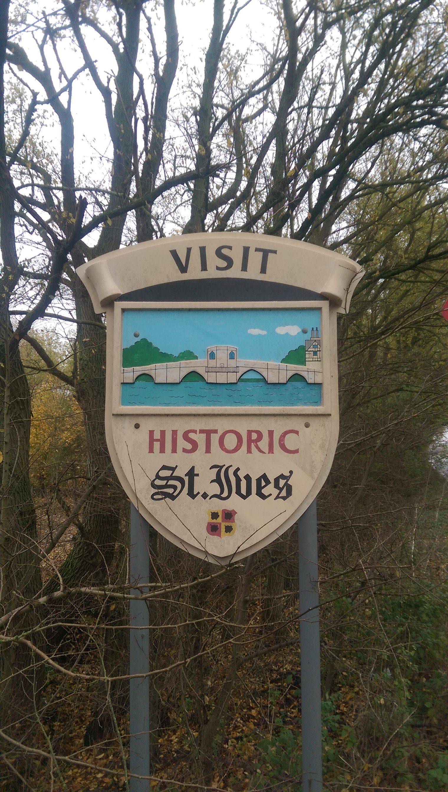
This cache belongs to the Village Sign Series, a series of caches based on ornate signs that depict the heritage, history and culture of the villages that put them up (generally on the village green!).
The signs can be made of different materials from fibreglass to wood, from forged steel to stone. They can depict anything from local industry to historical events. The tradition probably started in Norfolk or Suffolk and has now spread across most of the country so we thought we would base a series on them!
|
More information, bookmarks and statistics can be found at the Village Signs Website
If anybody would like to expand the Village Sign Series, please do.
I would ask that you request a number for your cache first at www.villagesignseries.co.uk
so we can keep track of the Village Sign numbers and names to avoid duplication.
St Ives is a market town in Cambridgeshire, England, around 19 kilometres (12 mi) north-west of the city of Cambridge and 90 kilometres (56 mi) north of London. It lies within the historic county boundaries of Huntingdonshire.
Previously called Slepe, its name was changed to St Ives after the body, claimed to be that of a Persian bishop, of Saint Ivo (not to be confused with Ivo of Kermartin), was found buried in the town in about 1001/2. For the past 1,000 years it has been home to some of the biggest markets in the country, and in the thirteenth century it was an important entrepôt, and remains an important market in East Anglia.
Built on the banks of the wide River Great Ouse between Huntingdon and Ely, St Ives has a famous chapel on its bridge. In the Anglo-Saxon era, St Ives's position on the river Great Ouse was strategic, as it controlled the last natural crossing point or ford on the river, 80 kilometres (50 mi) from the sea. The flint reef in the bed of the river at this point gave rise to a ford, which then provided the foundations for the celebrated bridge.
During the 18th and 19th centuries, St Ives was a hub of trade and navigation, and the town had dozens of inns and many bawdy houses. Goods were brought into the town on barges, and livestock rested on the last fattening grounds before delivery to London's Smithfield Market. As the railway network expanded and roads improved, the use of the River Great Ouse declined. It is now mostly used for leisure boats and recreation.
The river Great Ouse at St Ives flooded in 1947, and some parts suffered seriously again at Easter 1998 and in January 2003. Extensive flood protection works were carried out on both sides of the river in 2006/2007 at a cost of nearly £9 million. 500 metres (1,600 ft) of brick-clad steel-piling was put into place to protect the town, most noticeably at the Waits where a pleasing plaza has also been created. A further 750 metres (2,460 ft) on the other side of the river protects Hemingford Grey, reducing the yearly risk of flooding from 10% to 1%. Building on the flood plain at St Ives is now discouraged.
The cache is just south west of the village sign on the B1040, parking at GZ travelling towards St Ives. Please do not go climbing all over the sign!
A black micro tube, byop