En géologie, on appelle synclinal un pli concave dont le centre est occupé par les couches géologiques les plus jeunes.
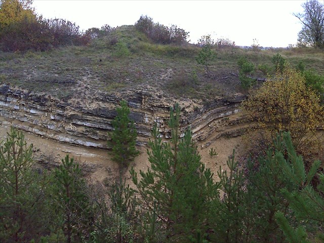
Des affleurements continus se succèdent suivant la voie ferrée en direction de Velaine-en-Haye. Il faut parcourir 200 à 300 mètres avant d'observer les premières strates (alternances marno-calcaires) sur le talus est du chemin de fer. Le bas du talus est généralement recouvert par les éboulis masquant la base des formations affleurantes. De bas en haut, les premières couches sont formées de :
- calcaire à oolithes fines - 20 cm d'épaisseur ;
- calcaire à pseudo-oolithes grossières - 80 cm d'épaisseur ;
- marnes à oolithes grossières (sommet du talus).
Ces couches font partie de la formation appelée oolithe à Clypeus ploti (Bajocien supérieur). L'oursin (C. ploti) caractéristique de cette formation peut être récolté à différents endroits.

Ces strates peuvent être suivies jusqu'au flanc nord du synclinal marqué par une faille, soit 200 mètres environ après les premiers affleurements.
L'emplacement de la faille peut aussi être repéré sur le talus ouest mais plus difficilement car colonisé par la végétation. Il est ainsi possible de déterminer son orientation : NNE-SSO.

La coupe se termine par le flanc sud du synclinal marqué lui aussi par une faille, moins inclinée (70°) mais de même direction que la première : NNE-SSW; photo 4.

Les formations précédentes indiquent un milieu marin de sédimentation ordinairement calme à modéré.
Les failles observées qui bordent un compartiment affaissé où se trouve le synclinal, possèdent une orientation NNE-SSO qui correspond à celle des fossés tectoniques connus plus au sud dans la région (fossés de Colombey-les-Belles et de Bicqueley par ex.) et dont la mise en place débute à la fin du Bajocien .
Cette sortie ne fera pas de vous de grands géologues mais par l’observation vous pouvez maintenant mettre un nom sur cet accident de paysage qui s’offre à vous.
Afin de valider votre visite je vais vous demander de répondre à ces quelques questions.
Au niveau du synclinal :
Quelle est l’orientation de la tranchée de l’ex chemin de fer?
Dans quelle direction le pli est-il incliné ?(direction de la pente du thalweg)
Quel nom donne-t-on à l’inverse du synclinal ?
Insérez dans votre log un lien vers un autre synclinal dans le monde.
Envoyez-moi vos réponses par mail à leguili
Vous pouvez loguer immédiatement votre découverte sans attendre ma réponse tout en sachant que tout log sans envoi des réponses sera invalidé.
ENGLISH VERSION WITH GOOGLE
In geology, a syncline is called concave fold whose center is occupied by the younger geological layers.
Continuous outcrops succeed following the track towards Velaine-en-Haye. Must travel 200 to 300 meters before observing the first strata (limestone-marl alternations) on the eastern slope of the railway. The bottom of the slope is generally covered by scree masking the basis of outcropping formations. From bottom to top, the first layers are formed:
oolitic limestone fines - 20 cm thick;
pseudo-oolitic limestone coarse - 80 cm thick;
marl ooliths coarse (top of the slope).
These layers are part of the training referred to oolithe Clypeus ploti (upper Bajocian). The sea urchin (C. ploti) characteristic of this training can be harvested at different locations.
These strata can be traced to the northern flank of the syncline marked by a fault, about 200 meters after the first outcrops.
The location of the fault can also be spotted on the west slope but more difficult for colonized by vegetation. It is thus possible to determine its orientation: NNE-SSW.photo2
The cut ends in the southern flank of the syncline also marked by a fault, the less inclined (70 °) but in the same direction as the first NNE-SSW; photo 4.
Previous formations indicate a marine environment usually quiet to moderate sedimentation.
Observed faults bordering a collapsed compartment where the syncline, have a NNE-SSW direction which corresponds to the known tectonic trenches farther south in the region (ditches Colombey-les-Belles and Bicqueley eg.) And whose implementation began in the late Bajocian.
This output will not make you great geologists but by observation you can now put a name to this accident landscape before you.
To validate your visit I will ask you to answer these questions.
At the syncline:
What is the orientation of the trench of the former railroad?
In what direction the fold is skewed?
What name do we give to the inverse of the syncline?
Insert a link to your log another syncline in the world.
Send me your answers by email to leguili
You can log your discovery immediately without waiting for my response, knowing that all log without sending replies will be invalidated.