PL
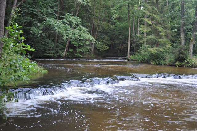
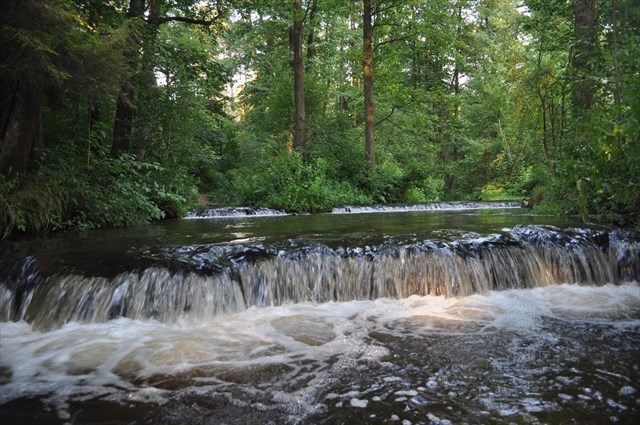
PL Roztoczańskie wodospady zwane są tutaj lokalnie jako szumy lub szypoty. Powstały na skutek ruchów górotwórczych w trzeciorzędzie, gdy Roztocze zostało wydźwignięte w górę, a Kotlina Sandomierska obniżyła się. Na granicy geologicznej powstała linia spękań tektonicznych w postaci uskoków w kompleksie skał mezozoicznych. Płynąca po nich doliną o spadku dna 10‰ meandrami rzeka Tanwia zyskała malownicze progi. To są właśnie dzisiejsze szumy.Charakteryzują się regularnym ułożeniem, przeważnie wzdłuż prostych linii, zgodnym z kierunkiem spękań utworów kredowych Roztocza. Lewe, zbocze doliny Tanwi, zbudowane z gezy górnokredowej przykrytej kompleksem skał mioceńskich, jest bardziej strome niż zbocze prawe – zbudowane z górnokredowych gez marglistych, przykrytych około 20 metrową pokrywą czwartorzędowych osadów piaszczystych. Kręty bieg rzeki został wymuszony przez akumulację eolicznych piasków pokrywowych na północnym, stosunkowo łagodnie nachylonym zboczu doliny w późnym glacjale. Na brzegu zewnętrznym meandru (amfiteatr fot. nr 1) widoczne jest wyraźne podcięcie jednego z zakoli o wysokości około 2 m, w którym odsłania się zróżnicowany litologicznie profil. W spągu profilu występują warstwy ułożone rytmicznie mułów piaszczystych, mułków laminowanych humusem i piasków mułkowych w laminach o miąższości 1-6 cm. W stropie natomiast dominują piaski średnio- i drobnoziarniste o słabo zaznaczającym się warstwowaniu. Zakole meandru Tanwi jest ponadto przykładem klasycznego (podręcznikowego) zakola, w którym widoczne są procesy erozyjno-akumulacyjne. Krawędź Roztocza jest wyraźnie zaznaczającym się w rzeźbie terenu fragmentem biegnącej tędy granicy geologicznej pomiędzy fałdową Europą Zachodnią i płytową Europą Wschodnią. Jest to zarazem jedna z najwyraźniej zaznaczonych granic fizjograficznych w Polsce.
Aby zalogować znalezienie tego EarthCache, musisz udać się pod wskazane współrzędne, odpowiedzieć na poniższe pytania. "Odpowiedzi proszę wysyłać za pomocą mojego profilu. Nie trzeba czekać na moją odpowiedź, można od razu logować. Jeśli coś będzie nie tak, zgłoszę się sam. Pamiętajcie proszę, że logi bez podesłanych odpowiedzi będą kasowane.
1/ Określ na swoim GPS wysokość w m n.p.m na której znajdują się progi skalne?
2/ Podaj Erę, Okres i Epokę powstania w/w formacji
3/ Określ wysokość progów skalnych oraz podaj w stopniach ich kierunki przebiegu NW-SE (azymuty)
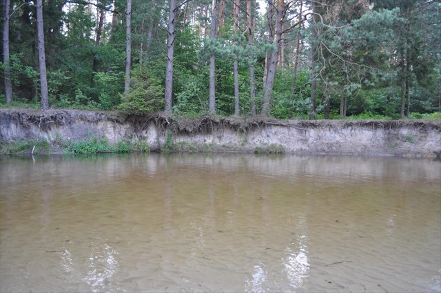
EN Roztocze waterfalls are called here locally as noise or szypoty. Arose as a result of tectonic movements in the Tertiary, when the mites were wydźwignięte up, and the Sandomierz Basin decreased. On the border of the geological tectonic fracture line was created in the form of complex faults in the Mesozoic rocks. Flowing over them through the valley of the slope of the bottom 10 ‰ meandering river Tanwia gained picturesque thresholds. These are just today szumy.Charakteryzują a regular arrangement, mostly along the straight line, the direction of the cracks Cretaceous mites. Left, the slope of the valley Tanew built with Geza Upper Cretaceous rocks of Miocene covered complex is steeper than the slope right - built from the Upper Cretaceous marl gez, covered about 20 meter sandy sediments of Quaternary cover. Tortuous course of the river has been forced by the accumulation of aeolian sands over cover on the north, a relatively gently sloping hillside in the late glacial valley. On the outer edge of the meander (amphitheater pic. No. 1) there is a clear undercut one of the bends with a height of about 2 m, which revealed diverse lithologically profile. The profile of the floor layers are arranged rhythmically mules sand, silt and humus laminated sands mułkowych in laminach 1-6 cm thick. The ceiling while dominated by medium and fine-grained sands with poorly zaznaczającym the stratification. Tanew meander bend is also a classic example (textbook) meanders, which are visible the processes of erosion and accumulation. Mites edge is clearly zaznaczającym in the relief portion of the geological boundary that runs through here between the folds of Western Europe and Eastern Europe plate. It is also one of the clearly marked boundaries of physiographic in Poland.
To log in finding EarthCache, you must go to the indicated coordinates, answer the following questions. "The answers, please send it via my profile. No need to wait for my answer, you can immediately log in. If something goes wrong, I call myself. Please remember that no logs submitted answers will be deleted."
1 / Specify your GPS altitude / AMSL/ at which thresholds are rock?
2 / Give Era, Period and Age of the uprising in / in formation
3 / Specify the height of the rapids and give them directions in degrees Running NW-SE (azimuths)
Na podt.geoportal, wikipedia.