O ÍNDIO DO CORVO

[Corvo – Azores]
EARTHCACHE
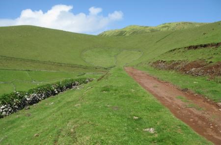
(Foto Spoiler)
PORTUGUÊS
A ilha do Corvo é a menor das ilhas do Arquipélago dos Açores, localizando-se no Grupo Ocidental, a norte (quinze milhas), da Ilha das Flores, formando com esta, o grupo Ocidental do Arquipélago. É a ilha mais pequena do Arquipélago, com uma superfície de 17,45 km2, tendo de comprimento 6,5 km e de largura 4 km. Está situada a 31º 05' de longitude oeste e a 39º 40' de latitude norte.
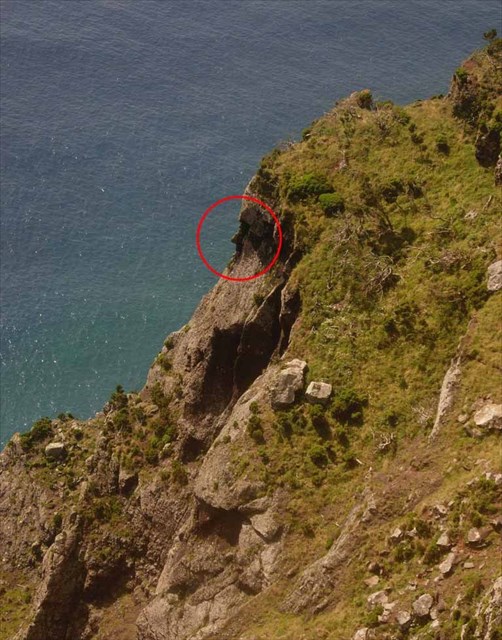
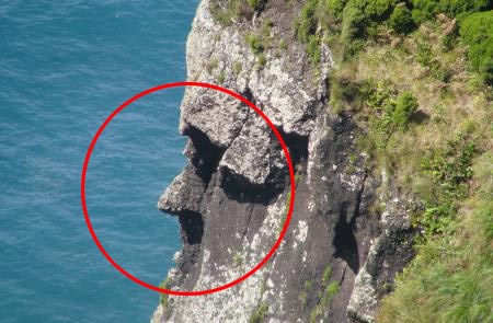
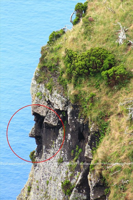
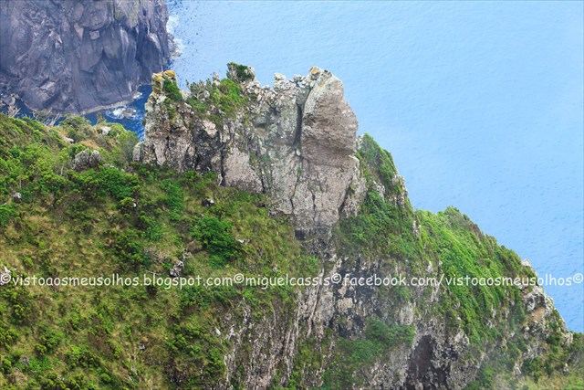
Cara do Índio
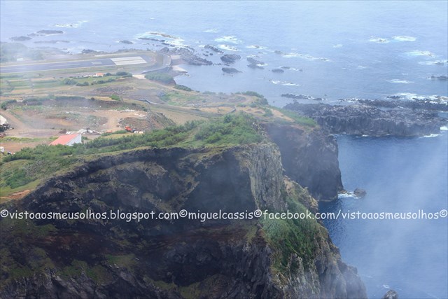
Esta escarpa é uma das mais emblemáticas e famosas da ilha. Situa-se na zona oeste, uma das mais ventosas e em pleno Baldio. Para apreciar esta paisagem basta seguir o trilho homologado que aí se encontra e poderá deparar-se com a inebriante "cara do índio" a observar o mar.
Geologia do Corvo
A ilha localiza-se sobre a placa tectónica norte americana, a oeste do rifte da Crista Média Atlântica (sigla CMA), edificada sobre fundo oceânico com cerca de 10 milhões de anos. As ilhas das Flores e do Corvo emergem do mesmo banco submarino, de orientação NNE-SSO. A sua tectónica é controlada por falhas orientadas aproximadamente Norte-Sul, paralelas à Crista Média Atlântica e por falhas transformantes com direção Oeste-Este, que segmentam o vale do rifte. A ilha corresponde a um vulcão do tipo central, que começou a emergir há cerca de 730 mil anos. O colapso da cratera terá ocorrido há 430 mil anos. Antes da formação da cratera, estima-se que o cone central teria cerca de 1 000 metros de altitude.
Aliado à erosão marinha, a ilha enfrenta erosão provocada pelos ventos dominantes de nordeste e oeste. As vertentes do vulcão encontram-se parcialmente preservadas nos flancos Sul e Leste (com altitudes entre 150 a 250 metros), muito reduzidas pelo recuo das arribas litorais a norte e completamente ausentes a oeste (com altitudes entre 500 a 700 metros). O recuo das arribas já alcançou o bordo oeste da caldeira. Na vertente sul, sobressaem cones secundários – Coroinha, Morro da Fonte, Grotão da Castelhana e Coroa do Pico – que se encontram bem preservados da ação erosiva, responsáveis pelo derrames basálticos que formaram a fajã lávica (com altitudes entre 10 a 60 metros).
A extremidade noroeste da ilha constitui a Ponta Torrais, saliente e notável, em espinhaço aguçado e com cristas pontiagudas, tendo na sua face norte um pequeno ilhéu cónico, o ilhéu dos Torrais. Na costa norte e noroeste existe outro pequeno ilhéu, o Ilhéu do Torrão, e alguns recifes submersos perigosos para a navegação.
PERCURSO PEDESTRE:
Cara do Índio - Corvo PR1COR
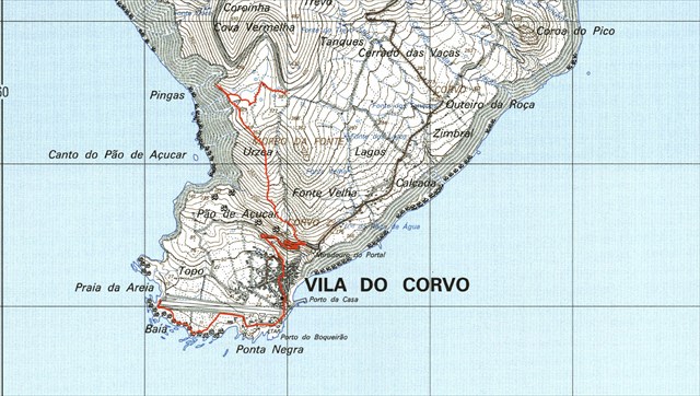
Este percurso inicia-se junto à Cova Vermelha, termina na Vila Nova do Corvo e tem a duração aproximada de 2h30, conduzindo o geocacher até uma altitude cerca de quatrocentos metros.
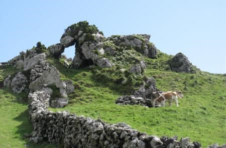
O percurso, com uma extensão de aproximadamente 4,5 km, tem uma forma linear, é de dificuldade média e segue por antigas “canadas” ladeadas por muros de pedra e vai em direção à costa. Ao chegar junto da falésia volta-se à direita para um desvio onde se pode observar a cara de um Índio esculpida na rocha.
Após a descoberta do Índio, volta-se pelo mesmo caminho mas agora continuando sempre junto à arriba. Seguindo a sinalética, encontrará um pouco à frente uma antiga canada por onde deve seguir, descendo sempre até à Vila Nova do Corvo.
O trilho estende-se pelo espaço compreendido entre o Morro da Fonte, Urzea e Pão de Açúcar, ao longo do limite de duas zonas de proteção especial da natureza. Uma zona classificada como Zona de Interesse Especial, (ZIE) e outra classificada como Sítio de Interesse Comunitário (SIC) dada a riqueza da flora carregada de plantas endémicas da Macaronésia que constituem um habitante único na ilha.
Poderá encontrar pelo caminho antigos abrigos, interessantes formações geológicas, líquenes de grandes dimensões a provar a pureza dos ares açorianos e também belos cedros-do-mato (Juniperus brevifolia) que proliferam em certos locais. Depois da chegada à vila, continue a caminhar pela parte antiga da única localidade da Ilha, passando pelo porto e junto à costa até chegar à zona balnear local. Para além te ter a maior concentração de Vidálias (Azorina vidalii), este zona em baixa altitude é local de excelência para observação de avifauna local e, com alguma sorte, poderá encontrar alguma espécie menos comum vinda do continente americano.
Depois desta caminhada, não há nada melhor do que um merecido mergulho na praia situada no fim do percurso.
Encontram-se também curiosas formações geológicas cuja origem se perde na formação da própria ilha e que devido aos milhares de anos de existência se encontram amaciadas pela erosão.
É também de referenciar a existência de típicos bebedores de animais, específicos desta ilha.

AS EARTH-CACHES
“A maneira mais interessante para aprender sobre a Terra e os seus processos é através de experiências ao ar livre e, contactando diretamente com os seus fenómenos.
Visitar uma “EarthCache” é uma actividade ao ar livre agradável para toda a família.
Uma “EarthCache” é um local especial que as pessoas podem visitar, para aprender sobre um fenómeno geológico e ou características raras do nosso Planeta.
As páginas das “EarthCaches” contêm dados educacionais e as coordenadas do local a visitar.
Os visitantes das “EarthCaches” podem observar os processos geológicos que transformaram a Terra, como administramos os recursos e, como os cientistas reúnem dados para aprenderem mais sobre o Planeta que habitamos”.
PARA REALIZAR E REGISTAR ESTA EARTHCACHE:
PERGUNTAS:
Para “encontrar/registar” esta cache deverá: provar que esteve no local e responder às seguintes questões, enviando um email/mensagem de Geocaching, com as respostas, em português ou em inglês, para o nosso perfil.
Só depois, de enviar as respostas, e conforme as “guidelines” para as Earthcaches, deverá efetuar o seu registo!
Serão removidos todos os registos que não obedeçam a estes requisitos.
1 a) Qual o tipo de material que compõe a formação rochosa “Cara do
Índio”?
b) Explique como se formou o fenómeno “Cara do Índio”.
c) Estime a altura da falésia onde se situa a “Cara do Índio”.
2 a) Relativamente ao outro interessante fenómeno que se situa no trilho e perto da “Cara do Índio”, identificada nesta descrição com a “Foto Spoiler”, qual o tipo de material que o constituí?
b) Qual o nome, geologicamente falando, que tem este fenómeno (Foto Spoiler)?
c) Identifica o tipo de fracturação e explica como se formou o fenómeno (Foto Spoiler).
3.
TAREFA OBRIGATÓRIA:Deverá tirar uma foto sua, onde você apareça (ou com um papel/placa onde conste o seu nickname e a data da visita) e que comprove a sua presença no GZ desta EC - NÃO METASPOILERS. Esta foto deverá ser colocada no seu registo ou enviada por email ou sistema de mensagens de Geocaching, para o owner!

Não responderemos ao seu contato, a não ser que haja algum “problema” com as suas respostas ou registo


AGRADECIMENTOS:
Um agradecimento especial a Daniel Oliveira, pela orientação, ajuda e publicação desta earth-cache.
Agradecemos, também, a especial colaboração do amigo:
Professor Doutor Victor-Hugo Forjaz - Vulcanólogo de Engenharia, Jubilado
e do Observatório Vulcanológico e Geotérmico dos Açores (OGVA)
THE INDIAN OF CORVO’S ISLAND
[Azores]
ENGLISH

Corvo Island is the smallest of the Azores islands, being located in the Western Group, the north (fifteen miles), the Island of Flowers, forming with it, the Western group of the Archipelago. It is the smallest island of the archipelago, with an area of 17.45 km2, with 6.5 km long and 4 km wide. It is situated 31 05 'west longitude and 39 40' north latitude.
Face Indio
This escarpment is one of the most iconic and famous of the island. Is located in the west, one of the windiest and a full Wasteland. To appreciate this landscape just follow the trail that there is approved and you may be faced with the heady "Indian face" to observe the sea.
Geology of “Corvo”
The island is located on the North American tectonic plate to the west rift of the Mid-Atlantic Ridge (acronym CMA), built on the ocean floor about 10 million years. The islands of Flores and Corvo emerge from the same submarine bank, NNE-SSW direction. Its is controlled by tectonic faults oriented roughly from north to south, parallel to the Mid-Atlantic Ridge and transform faults with west-east direction, that segment of the rift valley. The island corresponds to a central type volcano, which began to emerge about 730 thousand years. The collapse of the crater will have occurred 430,000 years ago. Before the formation of the crater, it is estimated that the central cone would be about 1000 meters of altitude.
Allied to marine erosion, the island faces erosion caused by prevailing winds from the northeast and west. The slopes of the volcano are partly preserved in the southern and eastern flanks (with altitudes between 150-250 meters), greatly reduced by the retreat of coastal cliffs to the north and west completely absent (with altitudes between 500-700 meters). The retreat of the cliffs already reached the western edge of the caldera. On the southern slope, stand side cones - Chaplet, Morro da Fonte, Grotão of the Castilian Crown and Pico - which are preserved from erosive action, responsible for basaltic lava flows that formed the fajã (with altitudes between 10 to 60 meters).
The northwest end of the island is the tip Torrais, salient and remarkable, in a sharp ridge and having sharp ridges, having on its northern face a small conical islet, the islet of Torrais. In the north and northwest coast there is another small islet, the islet of Clod, and some hazardous to navigation submerged reefs.
Hikes:
Indian Face - Corvo PR1COR
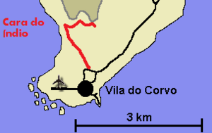
This route starts near the "Cova Vermelha", ends in Vila Nova do Corvo and has an approximate duration of 2:30 am, the geocacher leading up to an altitude of about four hundred meters.
The route, with a length of approximately 4.5 kilometers, has a linear form, is of medium difficulty and follows by old "canadas" flanked by stone walls and goes towards the coast. On reaching the cliff turns right onto a detour where you can see the face of an Indian carved in the rock.
After the discovery of the Indian, turn the same way but now always continuing along the cliff. Following the signs, find a little ahead an old canada where to follow, always down to Vila Nova do Corvo.
The trail extends through the space between the Morro da Fonte, Urzea and Sugar Loaf, along the boundary of two zones of special protection of nature. An area classified as Zone Special Interest (zie) and one classified as a Site of Community Interest (SCI) due to the wealth of flora loaded with Macaronesian endemic plants that constitute a single inhabitant on the island.
You can find the old way shelters, interesting geological formations, large lichens to prove the purity of the Azorean air and also beautiful cedars of bushes (Juniperus brevifolia) that proliferate in certain places. After arrival at the village, continue walking through the old part of the single location of the island, past the harbor and along the coast until you get to the local beach area. In addition you have the highest concentration of Vidalias (Azorina vidalii), this low-lying area is prime location for bird watching spot and, with any luck, you can find some less common species coming from the American continent.
After this hike, there is nothing better than a well-deserved swim at the beach located at the end of the route.
They are also curious geological formations whose origin is lost in the formation of the island itself and that due to the thousands of years of existence are softened by erosion.
It also sites the existence of typical drinkers animals, specific to this island.
THE EARTH-CACHES
“The most interesting way to learn about the Earth and its processes is through outdoor experiences and contacting directly with its phenomena.
Visiting a "EarthCache" is an enjoyable outdoor activity for the whole family.
An "EarthCache" is a special place that people can visit to learn about a geological phenomenon and or rare features of our planet.
The "EarthCaches" pages contain educational data and the coordinates of the place to visit.
Visitors of the "EarthCaches" can observe the geological processes that have transformed the Earth, we manage the resources and how scientists gather evidence to learn more about the planet we inhabit”.
TO PERFORM AND LOG THIS Earth-Cache:
QUESTIONS:
To "find / register" this cache must: prove that visited the site and answer the following questions by sending an email / message Geocaching, with answers (in Portuguese or in English, only) to our profile.
Only later, sending the answers, and as the "guidelines" for EarthCaches should make your registration! They will be removed from all records that do not meet these requirements.
1 a) What kind of material that makes up the rock formation
“Indian Face"?
b) Explain how the “indian face” phenomenon was formed.
c) Estimate the height of the cliff where the "Indian Face" lies.
2 a) As for the other interesting phenomenon that lies on the trail and close to
"Indian Face" identified with this description, what type of
material ia it made of (Photo Spoiler)?
b) What is the name, geologically speaking, for this phenomenon
(Photo Spoiler)?
c) Identify the type of fracturing and explain how it formed
the phenomenon (Photo Spoiler).
3.
TASK (not optional): You must take a picture of yourself, where do you show up, (or with a paper / plaque with your geocaching nickname and the date of the visit) and that proves your presence in the GZ of this EC - no spoilers please. This photo must be placed in your log or sent by email or Geocaching messaging system, to the owner!
We do not respond to your touch, unless there is a "problem" with their answers or register.
THANKS
Special thanks to Daniel Oliveira for the validation, research and support for this EarthCache.
We, also, appreciate the special collaboration of the friends: Miguel Cassis and the Professor Victor-Hugo Forjaz - Volcanologist Engineering, Emeritus
and Volcanological and Geotermic Observatory of Azores (OGVA)