28.3.2024: Könnte bitte der nächste Cacher ein Ersatzlogbuch/Zettel mitbringen und das Doserl ev. auch trocken wischen. Herzlichen Dank!
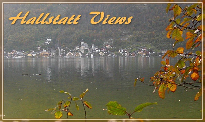
Dieser Multi zeigt euch den Ostuferwanderweg des Hallstättersees. Ein Spazier- und Radweg ohne Autos bis zur Stelle gegenüber von Hallstatt. Von hier habt ihr wunderbare Blicke auf den weltbekannten Ort, wie sonst nur noch vom Schiff aus. Außer der Hallstatt-Skyline werdet ihr die Schiffsanlegestelle, die leicht schwankende Hängebrücke, die Eisenbahn und sogar einen quasi Lost Place erblicken 
Dauer: vom Parkplatz ca. 1,5 h; vom Bahnhof: ca. 50 Minuten (jeweils zu Fuß)
Parkplatz Obertraun: N 47° 33.602, E 13° 40.726
 Vom Parkplatz aus immer am Seeufer entlang den Ostuferweg nach Nordwesten. Zuerst könnt ihr dort noch 2 empfehlenswerten Tradis (Lichtstein, Seeruhe) absolvieren. Anschließend werdet ihr ein gutes Stückl neben einem grünen Zaun entlang spazieren. Hinter der ganzen Botanik "versteckt" sich übrigens Schloss Grub, das leider nur vom See aus sichtbar ist.
VIEW 1: N 47° 33.866, E 13° 39.780
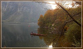
Hier erscheint euch der erste grandiose Blick über den See auf Hallstatt. Setzt euch so hinein, dass ihr *gerade aus* auf den alten Salzort schaut. Wieviele vertikale Holzbretter stützen nun *nur auf eurer Seite* euren Rücken? (= A)
VIEW 2
Spaziert ca. 350 m weiter nach Norden und dann links hinab zur Schiffsanlegestation. Übrigens, die verfallene Bruchbude am See-Eck war angeblich früher eine Werft. Ok, schaut euch ein bissl nach einer "Kundmachung" um. Es geht um die "neuerrichtete Haltestelle Hallstatt". In wessen Postamtslocale sind Zugbillets ab 1.6.1881 zu lösen? (B = 1. Buchstabe seines Vornamen)
(da Schiffstation umgebaut wird: B= Carl)
VIEW 3
 Geht nunmehr ein Stückl bergauf zur Eisenbahn-Haltestelle und haltet nach folgendem Detail Ausschau. Direkt darunter *schwarz auf gelb* einige Ziffern.
(C = Ziffernsumme) (nur die schwarz-auf-gelb Ziffern!)
VIEW 4
Etwa 400 m weiter nördlich eine markante Stelle am Ostuferwanderweg. Eine schmale Bucht und darüber sowohl eine Eisenbahnbrücke, als auch eine Hängebrücke für euch. Federt gut die Brücke  , außerdem befindet sich hier direkt vor euch in der Seemitte die tiefste Stelle des Hallstätter Sees (- 125 m). Schaut euch wieder ein bissl auf der Hängebrücke um: Wie hoch ist deren Tragleistung (= D) und die Spannweite (= E).
FINAL
Q = (A + 2*B + C)*10 + D
Z = 3*(E-1) + (A+B)*10 - 9
NORD 47° 33.500 + Q
OST 13° 39.500 + Z
Keine Geländer übersteigen, keine Schienen betreten, auf die Terrainwertung achten - aber nicht klettern!
Happy Hunting wünscht PPete!!

ENGLISH-VERSION
During this Cache you will enjoy some impressive views across the lake to the famous town Hallstatt from the hiking- and biking path at the Eastside of Lake Hallstättersee. You'll also see the ship-station, the railway-station and a rope bridge.
Duration: from parking lot ca. 1,5 h; from railway-station: ca. 50 minutes (walking)
Parking in Obertraun: N 47° 33.602, E 13° 40.726
Start from the parking lot to northwest, stay always at the hiking- and biking path next to lake Hallstättersee. Before you reach the Header coordinates of View 1, you could search 2 Tradis (Lichtstein, Seeruhe).
VIEW 1: N 47° 33.866, E 13° 39.780
The first lovely view across the lake at Hallstatt. Take a seat inside the hut, so that you can look *straight ahead* at Hallstatt. How many vertical wooden planks are behind your back *just at the side* of your seat? (= A)
VIEW 2
Walk on ca. 350 m to the North and then turn left, down to the ship-station. Search for "Kundmachung" and in detail for "neuerrichtete Haltestelle Hallstatt".
"... die Billets im Postamtslocale des Herrn ..."
Take the first letter of the following word (a forename) and convert it to a number (A=1, B=2, C=3, etc.) (= B)
(Since a new ship-station is under construction, so: B= Carl)
VIEW 3
Walk up about 40 meters to the railway-station and look for the detail of the photo. Just below it you can see several *black digits on yellow background*. Sum each of the black digits! (= C)
VIEW 4
Walk on 400 m to the North and you'll reach a small bay which is spaned by a large railway bridge and a rope bridge for the hikers and bikers. Search on the rope bridge for the following informations: "Tragleistung" (= D) and "Spannweite" (= E).
FINAL
Q = (A + 2*B + C)*10 + D
Z = 3*(E-1) + (A+B)*10 - 9
N 47° 33.500 + Q
E 13° 39.500 + Z
Don't climb across the railings of the path, don't enter the railway-tracks, have a look at the Terrain-rating - but don't climb!
Happy Hunting, PPete!!