Hard to believe this whole area at one time was a great big ocean/sea! The sediments laid down for millions of years show up in the oddest places.
Major Tectonic events helped shape what is now South and Central Idaho Mother Nature also threw in some Volcanism. Between the Volcanism, intrusion, faulting and sedimentation Montpelier Canyon is just a beautiful drive and well worth stopping and taking a look once in a while during your trip down Highway 89.
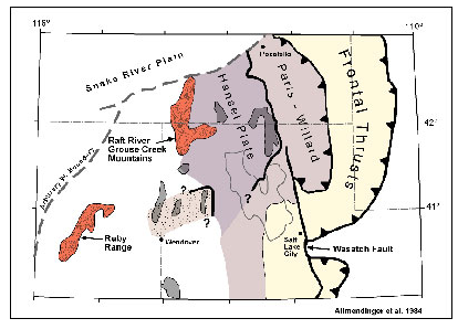

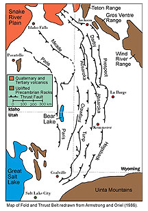
In Idaho the thrust faults trend Northwest-Southeast, very similar to the orientation of the faults within the Basin adn Range Provice. In SE Idaho (this area) it contains, The Paris thrust, the Meade thrust, and the Absaroka thrust. These fault layers or sheets are 10,000 to 20,000 feet thick in places and contain a lot of the Sedimentary rocks that were above these faults. The faults tend to get younger the farther East you go. The Paris thrust is 120-113 million years, the Meade 113-98 million years and the Absaroka is 84-74 million years old.
Some of these faults sedimentary layers have titled to create both odd and beautiful shapes which sometimes during contstruction of these highways we get lucky and they get exposed. They contain some sandstone, mudrock even pebble-to boulder-conglomerate that was deposited by fluvial and mass flow processes all those years ago. You can tell some of the mass flows by the size or thickness of the deposit.
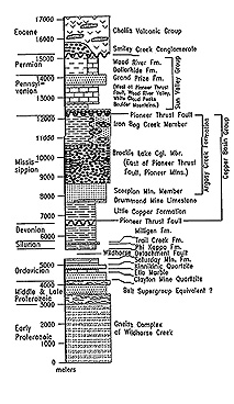
Nearby industries have taken advantage of some of these formations as the Meade thrust are Permian to Jurassic strata of the very large Phosphoria formation where they mine Phosphates. 10 to 15 percent of this country's Phosphate is mined in Idaho. All the mines are open pit mines and are easy to spot, although you'll not see any along this drive. This formation also was generating oil between 75-180 million years ago when the thrust faults were active. Down towards Montpelier you'll see some old oil wells. This formation was sought after for Uranium but it failed to yield any. Phosphate and Vanadium were both found.
Some of the fossils in this old area are Trilobites, Conulareids, and Brachiopods. The modern continental shelves of Namibia and Peru is where the primary productivity of organic matter found here came from. The resulting sediment within the Phosphoria formation is strongly enriched with this organic matter and it's sea fossils.
Logging Requirements: Please don't post pics of exact area
E-Mail me a note with:
1. The text "GC5DN84 Its Montpelier Canyons Fault"
2. How many people in your group today?
3. Do you see any tilt or angles at this location of this Formation? What is the Tilt? or Angle?
4. Take a 10 foot section and count how many main layers of rocks do you count? Don't worry about all the little ones, just the big main ones
5. Can you see a fault zone here? if so what main colors are they?
6. What casued some of these layers to be so thick?

The following Material were used for Reference:
- USGS mrdata/usgs.gov.mrds/show-mrds.php?
- U.S. Department of the Interior, Professional papers and Geological surveys
- Geology.isu.edu/digital-Idaho
- Regional geology and fossil sites from Pocatello to Montpelier, Idaho state university. David Fortsch and Paul Link
- Wyoming thrust belt province, Richard Powers
- Geochemistry of the Phosphoria formation at Montpelier Canyon Idaho,by D.Z.Piper and M.D.Medrano
- Wikipedia