
 This is considered a rather challenging EarthCache due to the distances between measurement points, the required equipment, and the math required. For this EarthCache you will need:
- transportation between the west and east side of the island over Saddle Road (in the least time as possible to get your readings as close together in time as possible)
- an altimeter (most GPS units will have this, though I know they are based on air pressure so they aren't that accurate)
- a thermometer (most cars have these now days)
- the dew point at Hilo International Airport (obtained from this website)
- the dew point at Kailua / Kona, Keahole Airport (obtained from this website)
A rain shadow is the dry area on the leward side of a mountain or mountain range. A rain shadow is formed when tall mountains force wet moist air up. As the air moves up, it expands due to the decreased pressure and cools. This phenomenon is called Orographic Cooling. As air cools, it looses its capacity to retain moisture forming clouds and eventually rain. As the air moves across the top of the mountain it then descends back down where it warms (Orographic Warming) and increases its potential to retain moisture and less rain forms.
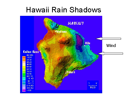 Mauna Kea and Mauna Loa force the warm moist trade winds from the west up and over their 12,000+ height. As the air masses gain altitude, they cool forming clouds and rain on the eastern slopes of Hawaii. The area just west of Hilo receives almost 300 inches of rain per year (the purple area in the figure). Then on the western side, the air descends and warms providing little rainfall. Some of the areas on the western side of the island receive only about 9 inches of rain per year (the red areas).
So what actually happens to make this large disparity in rainfall? While there are many factors that go into the process, it can be simplified to adiabatic cooling and heating. Adiabatic refers to the changing temperature of an air mass due to elevation changes. When air is unsaturated (isn't forming clouds) it cools at a rate of about 10 C per 1000 meters. This is called the dry adiabatic lapse rate (ADLP). During this time, the dew point remains at the same temperature. If the temperature of the air mass reaches its dew point clouds will form. This elevation is called the lifting condensation level (LCL)
Once clouds form, the air will cool at a slower rate of about 5 C per 1000 meters. This is called the wet adiabatic lapse rate (WALP). This slower rate is due to the release of energy from water vapor turning into liquid. The dew point will decrease at the same rate as the temperature of the air mass because when clouds are forming, the air is 100% saturated, which is the dew point.
On the leeward side, the air mass begins to warm and since it has lost its water, it warms at the ADLP. For simplification, the dew point increases at 2 C/ 1000 meters (there are actually many factors that go into that number, but this rate is useful for the concept).
 These changes are shown in the figure.
So as the air mass is pushed up the east side of Hawaii, it will cool at the ADLP until clouds begin to form, then cool at the WALP. On the west side of the island the air has lost its moisture and will warm constantly at the ADLP and the dew point will increase at the constant rate.
So now comes your measurements to fill in a chart like the one in the figure. I will assume you will be going from Hilo to Kona (wet to dry sides). Though you can do it backwards.
Begin by looking up the dew point at Hilo International Airport and putting it at the 0 elevation of the dew point column on the wet side. Record the temperature in Hilo (or other near sea level location on the east side of the island.
Now drive up to the top of Saddle Road and collect the elevation and temperature there. If there are clouds along the way get the elevation of where the bottom of the clouds start.
Finally drive back down to sea level on the west side of the Island. Record the temperature and look up the dew point at Kona International Airport.
Now for the calculations. Make sure all your units are metric, Centigrade and Meters.
First calculate the elevation that clouds should form, the LCL. This will tell you when to change from the ADLP to the WDLP.
LCL= ((Temperature at Hilo)-(Dew Point at Hilo))x (1000 meters/10 degrees C)
Next calculate the temperature at the top of the Saddle. This is drop in temperature at the ADLP until the LCL then the drop in temperature at the WDLP to the elevation of the saddle.
Temperature at LCL = (Temperature at Hilo) – ((10 degrees C/1000 meters) * LCL)
Temperature at top of Saddle = (Temperature at LCL) – ((5 degrees C/1000 meters) * (Saddle elevation – LCL))
If your calculations predict there would be no LCL then you use:
Temperature at top of Saddle = (Temperature at LCL) – ((10 degrees C/1000 meters) * (Saddle elevation))
Next calculate the temperature at Kona:
Temperature at Kona = Temperature at top of Saddle + ((10 degrees C/1000 meters) * (Saddle elevation))
Lastly calculate the dew point at Kona if there were clouds on the Hilo side of the mountain. Remember that the dew point and temperature are the same at the top of the saddle if the LCL was reached.
Dew Point at Kona = Temperature at top of Saddle +((2 degrees C/ 1000 meters) * (Saddle elevation)
I've provided an empty temperature figure to fill in if it helps. Remember that these temperature change rates are over simpliations of what is really happening.

This phenomenon is used by geologists in reconstructing paleoenvironments and paleogeography. As geologists get clues about the presence of ancient mountain ranges and latitudes they can predict which of the surrounding areas received more or less rainfall. Or the reverse, if they find a sediments from a dry environment they may postulate that a mountain range existed in a certain direction that blocked rain fall. Geologists may also expect different types of erosion on either side of these mountain ranges, constant water flow and a lot of biotic activity on the wet side, and infrequent high-flow events on the dry side.
For the logging requirements post your answers in the log:
- Post your measured Hilo and Kona temperatures along with their respective dew points that you looked up online.
- Post your calculated LCL, Top of Saddle temperature, and Kona Temperature and dew point.
- How do your calculated values compare to the measured values?
- What might account for your differences.
The above information was compiled from the following sources:
- http://www.trishock.com/academic/mountain.shtml
- http://www.theweatherprediction.com/habyhints/33/
- http://www.theweatherprediction.com/habyhints2/502/